|
December 09, 2003
ICESat Captures Earth in Spectacular 3-D Images
NASA�s Ice, Cloud and land Elevation Satellite (ICESat) is sending home important scientific data and spectacular 3-D views of Earth�s polar ice sheets, clouds, mountains, and forestlands. The data are helping scientists understand how life on Earth is affected by changing climate.
The principal objective of the ICESat mission, and its Geoscience Laser Altimeter System (GLAS) instrument, is to measure the surface elevations of the large ice sheets covering Antarctica and Greenland and determine how they are changing. Much of an ice sheet�s behavior and response to changes in climate are apparent in their shape and how that shape changes with time. The laser sends short pulses of green and infrared light to Earth 40 times a second and collects the reflected laser light with a one-meter telescope.
The measurements have provided revolutionary accuracy and detail about the elevation of ice sheets and the elevation structure of land surfaces. ICESat is providing scientists with the most accurate measurements to date of the heights of clouds. It is also providing critical observations of atmospheric particles, called aerosols, over the ice sheets and the rest of the world. These help climate modelers, who reconstruct the past and project future climate.
�NASA has developed tremendous capabilities over the last several decades for observing our Earth in two dimensions. With ICESat, we can see the critical third-dimension, that is, the vertical dimension of land, water, and the atmosphere, in new and innovative ways,� said Waleed Abdalati, ICESat Program Scientist, NASA Headquarters, Washington. �The first few months of ICESat data have really been phenomenal. We can see detail in ice and land features that were never visible before from space.�
Scientists are using ICESat data to develop what are called �Digital Elevation Models,� 3-D high-resolution images of ice sheets in Greenland and Antarctica. Gathering these data from space will allow scientists, to obtain an unprecedented view of how and where ice sheets are growing and shrinking. This information is critical to understanding how the Earth�s changing ice cover affects sea level.
Earlier this year, ICESat�s first topographic profiles across Antarctica revealed details never before seen of features such as the ice streams of the Siple Coast, the Amery Ice Shelf, and megadunes in the Antarctic interior.
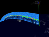
ICESat directly sees, for the first time from space, the height of all clouds and also aerosol layers from sources like dust storms and forest fires. The top graphic shows the vertical distribution of the laser light reflected from clouds and aerosols along a track over the Atlantic Ocean near the coast of Africa. The lower graphic shows a conventional two-dimensional satellite image taken at almost the same time. Credit: NASA
�The amount and coverage of heavy dust and pollution loading in many regions of the Earth that we are seeing in the initial ICESat data are unexpected,� said James Spinhirne, principal atmospheric scientist for ICESat at NASA�s Goddard Space Flight Center, Greenbelt, Md. These include the rivers of dust from the Sahara desert, massive dust storms, and large-scale smoke from burning vegetation. The observations tie smoke, dust and clouds directly to winds and global transport.
ICESat was launched January 12, 2003. It is the latest in a series of NASA Earth observation spacecraft designed to study the environment of our home planet and how it may be changing. NASA�s Earth Science Enterprise is dedicated to understanding the Earth as an integrated system and applying Earth System Science to improve prediction of climate, weather and natural hazards using the unique vantage point of space.
ICESat scientists will present the latest results from ICESat during a press conference on December 9 at 3:00 pm PT in Room 2012 Moscone West, at the 2003 Fall Meeting of the American Geophysical Union in San Francisco. They will also convene special sessions C31A and C31D detailing these results on December 10, beginning at 10:20am PT in the Moscone Center, Room MCC 3010.
B-roll video is available on the ICESat mission by calling Wade Sisler of NASA-TV at 301/286-6956.
###
Contacts:
David Steitz/Elvia Thompson
Headquarters, Washington
Phone: 202/358-1730/1696
Cynthia M. O�Carroll/Rob Gutro at AGU
Goddard Space Flight Center, Greenbelt, Md.
Phone: 301/614-5563/ at AGU: 415/348-4440
|
� |

ICESat
Criss-crossing the world below at nearly 17,000 miles per hour, ICESat is covering the Earth from space with unprecedented accuracy and detail. GLAS sends short pulses of green and infrared light though the sky 40 times a second, all over the globe, and collects the reflected laser light in a one-meter telescope. Although the signature goal of ICESat�s mission is to observe ice near the poles, the satellite makes measurements continuously around the entire globe, providing important information about our planet�s clouds, oceans, mountains, forests, and fields. Credit: NASA
High-Resolution Image

GLAS
ICESat�s single scientific instrument is called GLAS, for Geoscience Laser Altimeter System. It is the first instrument to map our planet using lasers from a dedicated satellite platform. Using one of its three onboard lasers, GLAS precisely measures the time it takes for a pulse of light to travel from the laser to a reflecting object, in this case the Earth�s surface and any intervening clouds, and return to detectors on the satellite. In addition, other parts of GLAS help determine precisely where GLAS is, relative to our world below. Credit: NASA
High-Resolution Image
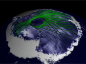
ICESat�s Orbit
ICESat�s orbit was designed to maximize coverage over the great polar ice sheets, where ground tracks overlap to create an intricate grid of data points. The accumulation of these data points in the Southern Hemisphere results in a new three-dimensional elevation model of Antarctica in better detail than ever before. For the first time, scientists will be able to tell from space exactly whether amounts of ice and snow in the middle of ice sheets are rising or falling from previous years as the Earth�s climate undergoes natural and human-induced changes. Credit: NASA
High-Resolution Image
A View of the Clouds
ICESat is providing scientists with the most accurate measurements of the heights of clouds and critical observations of atmospheric particles called aerosol. This animation shows the distribution of cloud layers as seen from the bird�s-eye perspective of the ICESat spacecraft. Credit: NASA
High-Resolution Image

Dust Over Africa
ICESat directly sees, for the first time from space, the height of all clouds and also aerosol layers from sources like dust storms and forest fires. The top graphic shows the vertical distribution of the laser light reflected from clouds and aerosols along a track over the Atlantic Ocean near the coast of Africa. The lower graphic shows a conventional two-dimensional satellite image taken at almost the same time. Credit: NASA
High-Resolution Image
|

