| Home >> | Advanced Search >> |
 |
|
Astronaut Photography - Observing Earth's Systems from Spaceby Rebecca Dodge in collaboration with NASA scientistsDynamic EventsHurricanes:
7. (http://earthobservatory.nasa.gov/Newsroom/NewImages/images.php3?img_id=10788 Astronaut Photos of Hurricane Lili) Astronaut observations will be critical resources for atmospheric and other Earth system research studies; the oblique viewing angles offered by ISS presents a three-dimensional perspective not available from automated satellite sensors. Astronaut can also observe dynamic phenomena repeatedly in a much shorter time frame than automated satellites with similar resolution. Dust Storms:Astronaut observations have opened whole new avenues of research into previously-undocumented connections among disparate elements of the Earth System. For example, the connection between desertification in the Sahel of North Africa and the decline of coral reefs in the Caribbean was not documented until astronauts observed and photographed large dust clouds in the atmosphere over the Caribbean Sea. According to Dr. Tony Phillips of NASA's Marshall Space Flight Center8, It's not unusual for astronauts to see what satellites do not. In 1994, for example, the crew of the space shuttle Columbia (STS-65) spotted a curious haze over the Caribbean Sea. It turned out to be a huge dust cloud from Africa, thousands of miles from the desert where it formed. Few scientists at the time had considered the possibility that such dust could drift all the way across the Atlantic Ocean. Down-looking satellites did not notice the thin clouds, yet astronauts looking at an angle saw them easily. 8. (http://science.nasa.gov/headlines/y2002/29may_lookingglass.htm Earthgazing, NASA-style)
9.(http://earthobservatory.nasa.gov/Newsroom/NewImages/images.php3?img_id=5151 African Dust Blows over the Caribbean) African dust impact beautifully demonstrates connections among all elements of the Earth's Systems. Unsuspected interactions have alarmed scientists from diverse disciplines, and led to intense study of dust storm around the world to analyze their impact on global climate cooling, soil loss, toxic algal blooms in freshwater and marine ecosystems, coral reef mortality, and public health. Principal dust storm source areas are typically facing System-wide change, related to natural climate cycles such as El Nino, long-term climate change processes, and human-induced effects.
10. (http://eol.jsc.nasa.gov/EarthObservatory/Lake_Chad_as_seen_from_Apollo-7_in_1968.htm Lake Chad as seen from Apollo-7 in 1968) 11. (http://earthobservatory.nasa.gov/Newsroom/NasaNews/2001/200102274546.html Why Africa's Lake Chad shrinks by 20 times due to Irrigations Demands, Climate Change All elements of the Earth System are involved in the genesis of this dust source area. A decrease in large rain events (atmosphere) impacts not only the amount of water in streams entering this internal drainage basin (hydrosphere), but also the soil moisture across the region. Drier soil supports less vegetation (biosphere), which previously anchored soil (lithosphere) and prevented erosion. Falling lake levels have desiccated the lake-supported ecosystems and destroyed a thriving fishing industry (biosphere). Falling lake levels have also exposed fine-grained lake-bottom sediments, which are easily eroded. Prevailing easterly winds (atmosphere) now have a previously-unavailable source for dust both from unvegetated soils and exposed lake bottom. The transformation of the Bodele Depression into a major dust source is part of an ongoing global process called "desertification"12, which is affecting areas where grassland ecosystems border deserts. Climate change only partially explains this process, which results in the expansion of the desert biomes at the expense of grasslands. In the Bodele Depression climate change is taking place at the same time that agricultural demands for water from the Chari/Logone river system, the principal stream entering the lake, have contributed significantly to lake level drop. What little water reaches Lake Chad is burdened with pesticides and fertilizer, which settles to the lake bottom to be exposed by further lake retreat and incorporated into dust storms. Overgrazing is also affecting the vegetation cover and exposing soils. Dust eroded from the Bodele Depression is charged with microorganisms from animal waste deposited by herds overgrazing the landscape. Bacteria, viruses, and mold also have harmful health effects on downwind areas on marine and terrestrial environments. 12. (http://earthobservatory.nasa.gov/Study/DustBowl/ From the Dust Bowl to the Sahel) The dust itself, once in the atmosphere, is carried across Africa towards the Atlantic. Air quality effects are evident across West Africa, the Atlantic, the Caribbean, and even the southern part of the U.S., where adverse health reactions (upper respiratory problems such as asthma) are associated with dust storms13. The dust also enters the ocean, where it acts as a source of nutrients for typically nutrient-poor ocean waters. Dust essentially "fertilizes" planktonic algae and can stimulate algae into overproduction, creating massive planktonic blooms. Plankton blooms are another target within the Dynamic Events theme of Crew Earth Observations. Excessive planktonic blooms result in massive amounts of decaying material that accumulate on the sea floor; decomposition deoxygenates seawater killing sea life including fish and corals. Not all of the effects of African dust are negative - it supports an entire ecosystem in the South American rainforest, where bromeliads rely on the dust for critical nutrients13. 13. (http://earthobservatory.nasa.gov/Study/Dust/ When the Dust Settles) Dust storms are not the only source of nutrient-laden sediments entering the ocean. Deforestation14 exposes soils to erosion; the effect of deforestation in Madagascar is vividly illustrated below in a photographic showing dramatic soil erosion filling the Betsiboka River estuary following heavy rainfall associated with Tropical Cyclone Gafilo, which hit Madagascar on March 7th and 8th, 2004. The photograph15 shows a red sediment-laden plume entering the Indian Ocean on Madagascar's west coast.
14. (http://earthobservatory.nasa.gov/Library/Deforestation/ Tropical Deforestation) 15. (http://eol.jsc.nasa.gov/EarthObservatory/BetsibokaEstuaryMadagascar.htm Betsiboka Estuary, Madagascar) 16. (http://earthobservatory.nasa.gov/Newsroom/NewImages/images.php3?img_id=15345 Deforestation in Madagascar) Planktonic Blooms:Soil entering the marine environment whether from dust storms or river sources can generate massive planktonic blooms by supplying enough nutrients for algal overproduction17. While this soil-sourced nutrient supply from the terrestrial Lithosphere has been a natural part of the terrestrial and marine Hydrosphere, the supply has been dramatically increased along developing coastlines.
17. (http://earthobservatory.nasa.gov/Study/Redtide/ Hunting Dangerous Algae from Space) 18. (http://earthobservatory.nasa.gov/Newsroom/NewImages/images.php3?img_id=16392 Water Boundaries) While plankton blooms are a vital Biosphere component of ecosystems in the Hydrosphere, deoxygenation caused by decay of copious amounts of planktonic algae in unusually massive blooms affects fisheries, further straining the resources of countries whose agricultural productivity is already washing into the ocean. Some planktonic blooms are even toxic, causing fish kills and illness or death in human coastal populations17.
|
 It is not a coincidence that thunderstorms rising through Earth's Atmosphere were the first picture taken from the ISS - understanding the impact of clouds and other dynamic atmospheric phenomena such as hurricanes as they relate to climate change is a principal challenge for the 21st century. As part of Crew Earth Observation Program's "Dynamic Events" theme Astronauts will photograph hurricanes, which can also hold personal interest for the ISS astronauts. Hurricane Lili shut down Houston's Mission Control on October 2, 2002, delaying the launch of the Space Shuttle carrying visitors and supplies for the ISS. The astronauts made good use of the delay, tracking and photographing the hurricane as it approached landfall. The photographs below7, taken with different lenses to obtain regional and detailed views of the storm, show Lili strengthening and growing rapidly between successive late afternoon orbits. Between orbits Lili's winds increased in speed from approximately 120 knots (upper photographs) to 125 knots (lower photographs), characteristic of a strong category 4 hurricane. This sequence highlights the short time frame required for the ISS to be in position to reacquire a target; at higher latitudes astronauts on the ISS can photograph a dynamic target several times in one day, in cooperation with ground and airborne observers.
 The photograph of African dust to the left9, taken on July 11, 1994 from the Space Shuttle, highlights the importance of astronauts' ability to capture dynamic, unpredictable events. "Target of opportunity photographs" such as this helped to stimulate scientist's interest in extent and impact of African-sourced dust storms, and ensuing research has indicated diverse impact across marine and terrestrial Systems. Dust storms in the Atmosphere are also part of the CEO Dynamic Events research program; astronaut photographs offer a three-dimensional perspective on dust storm events that can be captured most effectively be human observers with the oblique perspective available from the ISS.
 The photograph to the right9, which shows a vast sheet African dust moving towards the west, was taken by Space Shuttle astronauts while docked to the International Space Station on August 19, 2001. This extensive dust storm sourced from the Saharan Desert of North Africa, was tracked across the Atlantic into the Caribbean.
 Receding lakes around the world are primary sources of dust storms, and are being observed as part of the Crew Earth Observations program's Dynamic Events theme in an effort to facilitate regional and global assessment of climate change events. Perhaps the most dramatic evidence of regional climate change impact can been seen in the astronaut photography record of Lake Chad10, located in the Bodele Depression of northern Chad. The top image below shows Lake Chad in 1968; the three photographs below document striking shrinkage in the size of the lake. Lake Chad is today less than one-twentieth its size during the 1960s11. Regional climate change, specifically fewer large rainfall events, accounts for much of the decrease in size of Lake Chad. The Bodele Depression is a primary source of African Dust blowing into the Atlantic.
 Even during normal water levels, the Betsiboka River carries large amounts of sediment from the central highlands of Madagascar. Vast amounts of the forests of Madagascar have been replaced by coffee plantations and other cash crops such as cotton and tobacco. Burning of the forests is a typical way to clear the land for agriculture. Soil loss from exposed soils degrades water quality in the Hydrosphere, devastates unique ecosystems in the Biosphere, and destroys agricultural productivity, which necessitates further forest clearing16.
 The photograph to the left shows the eastern coastline of Argentina and Uruguay18, where the Rio de la Plata enters the Atlantic Ocean at Montevideo. Agricultural and ranching development is intensive in both countries, and eroded soil enters the Atlantic in broad freshwater plumes. Sediment-laden water is carried along the coastline and out into the open ocean, generating plankton blooms that appear as bright swirls in the center of the photograph. The ISS platform's rapid revisit capability allow almost real-time observations for scientists study the growth of blooms, a capability unavailable on other platforms.
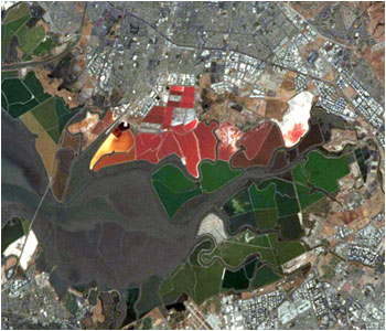
Server: 2 |
This service is provided by the International Space Station program. |
Recommended Citation: |
||

