| Home >> | Advanced Search >> |
 |
|
Astronaut Photography of Earth - Display Record
STS109-730-80
Low-resolution Browse Image
(Most browse images are not color adjusted.)Images
Conditions for Use of Images >>Image Transformation Tutorial >> Saving, Color Adjusting, and Printing Images >>
Images to View on Your Computer Now
| File Name | File Size (bytes) | Width | Height | Annotated | Cropped | Purpose | Comments | |
|---|---|---|---|---|---|---|---|---|
| View | STS109-730-80.JPG | 21009 | 515 | 492 | No | No | From ISD TIFF images | |
| View | STS109-730-80.JPG | 68550 | 540 | 539 | Yes | Yes | NASA's Earth Observatory web site | |
| View | STS109-730-80.JPG | 141215 | 540 | 539 | Yes | Yes | NASA's Earth Observatory web site | |
| View | STS109-730-80.JPG | 184593 | 768 | 768 | Photographic Highlights | actual files used | ||
| View | STS109-730-80_2.JPG | 193184 | 540 | 540 | Photographic Highlights | (540px resized images) | ||
| View | STS109-730-80.TIF | 2197055 | 875 | 836 | No | No | Photographic Highlights |
Large Images to Request for Downloading
| File Name | File Size (bytes) | Width | Height | Annotated | Cropped | Purpose | Comments | |
|---|---|---|---|---|---|---|---|---|
| Request | STS109-730-80.JPG | 1115357 | 4600 | 4400 | No | No | From ISD TIFF images | |
| Request | STS109-730-80.JPG | 1115357 | 4600 | 4400 | No | No | Photographic Highlights |
Download a Keyhole Markup Language (KML) file for use in Google Earth.
Electronic Image Data
Camera files only apply to electronic still cameras.No sound file available.
Identification
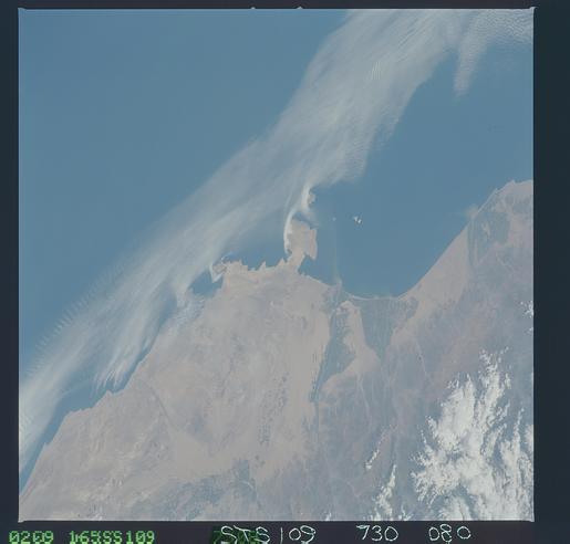
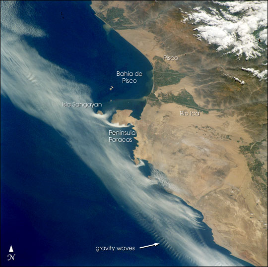
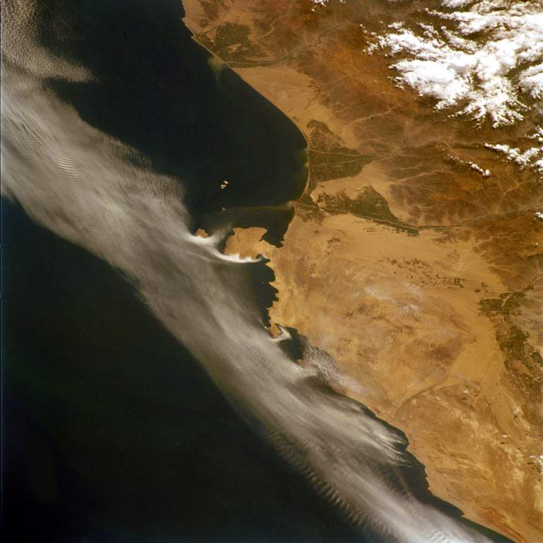
Mission: STS109 Roll: 730 Frame: 80 Mission ID on the Film or image: STS109Country or Geographic Name: PERU
Features: PARACAS PENINSULA, COASTAL FOG
Center Point Latitude: -14.0 Center Point Longitude: -76.5 (Negative numbers indicate south for latitude and west for longitude)
Stereo: (Yes indicates there is an adjacent picture of the same area)
ONC Map ID: JNC Map ID:
Camera
Camera Tilt: Low ObliqueCamera Focal Length: 250mm
Camera: HB: Hasselblad
Film: 5069 : Kodak Elite 100S, E6 Reversal, Replaces Lumiere, Warmer in tone vs. Lumiere.
Quality
Film Exposure:Percentage of Cloud Cover: 25 (11-25)
Nadir
Date: 20020309 (YYYYMMDD)GMT Time: 1646__ (HHMMSS)Nadir Point Latitude: , Longitude: (Negative numbers indicate south for latitude and west for longitude)
Nadir to Photo Center Direction:
Sun Azimuth: (Clockwise angle in degrees from north to the sun measured at the nadir point)
Spacecraft Altitude: nautical miles (0 km)
Sun Elevation Angle: (Angle in degrees between the horizon and the sun, measured at the nadir point)
Orbit Number:
Captions
Coastal fog commonly drapes the Peruvian coast. This image captures complex interactions between land, sea, and atmosphere along the southern Peruvian coast. When Shuttle astronauts took the image in February of 2002, the layers of coastal fog and stratus were being progressively scoured away by brisk south to southeast winds. Remnants of the cloud deck banked against the larger, obstructing headlands like Peninsula Paracas and Isla Sangayan, giving the prominent “white comma” effect. Southerlies also produced ripples of internal gravity waves in the clouds offshore where warm, dry air aloft interacts with a thinning layer of cool, moist air near the sea surface on the outer edge of the remaining cloud bank. South of Peninsula Baracas, the small headlands channeled the clouds into streaks—local horizontal vortices caused by the headlands provided enough lift to give points of origin of the clouds in some bays. Besides the shelter of the peninsula, the Bahia de Pisco appears to be cloud-free due to a dry, offshore flow down the valley of the Rio Ica.Download Packaged File.
This option downloads the following items, packaged into a single file, if they are available:
- Browse image
- Cataloged information with captions
- Camera file
- Sound file
Server: 2 |
This service is provided by the International Space Station program. |
Recommended Citation: |
||

