| Home >> | Advanced Search >> |
 |
|
Astronaut Photography of Earth - Display Record
STS097-351-12
Low-resolution Browse Image
(Most browse images are not color adjusted.)Images
Conditions for Use of Images >>Image Transformation Tutorial >> Saving, Color Adjusting, and Printing Images >>
Images to View on Your Computer Now
| File Name | File Size (bytes) | Width | Height | Annotated | Cropped | Purpose | Comments | |
|---|---|---|---|---|---|---|---|---|
| View | STS097-351-12.JPG | 29865 | 515 | 343 | No | No | From ISD highres, sharpened | |
| View | STS097-351-12.JPG | 35323 | 540 | 342 | Yes | NASA's Earth Observatory web site | ||
| View | STS097-351-12.JPG | 302872 | 540 | 360 | Photographic Highlights |
Large Images to Request for Downloading
| File Name | File Size (bytes) | Width | Height | Annotated | Cropped | Purpose | Comments | |
|---|---|---|---|---|---|---|---|---|
| Request | STS097-351-12.JPG | 1633134 | 2976 | 1986 | No | No | From ISD CD TIFF images | |
| Request | STS097-351-12.TIF | 4164823 | 1459 | 951 | No | No | NASA's Earth Observatory web site |
Download a Keyhole Markup Language (KML) file for use in Google Earth.
Electronic Image Data
Camera files only apply to electronic still cameras.No sound file available.
Identification
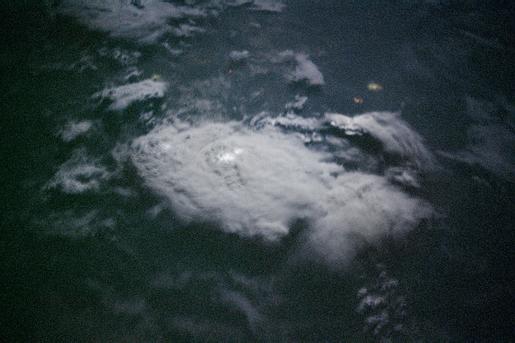
Mission: STS097 Roll: 351 Frame: 12 Mission ID on the Film or image: STS97Country or Geographic Name: AFRICA
Features: NIGHT THUNDERSTORM
Center Point Latitude: Center Point Longitude: (Negative numbers indicate south for latitude and west for longitude)
Stereo: (Yes indicates there is an adjacent picture of the same area)
ONC Map ID: JNC Map ID:
Camera
Camera Tilt:Camera Focal Length: mm
Camera: NK: Nikon 35mm film camera
Film: 5755 : Portra 160NC, color negative, 35mm, ASA 160.
Quality
Film Exposure:Percentage of Cloud Cover: (0-10)
Nadir
Date: 20001211 (YYYYMMDD)GMT Time: 033445 (HHMMSS)Nadir Point Latitude: 4.4, Longitude: 3.5 (Negative numbers indicate south for latitude and west for longitude)
Nadir to Photo Center Direction:
Sun Azimuth: 114 (Clockwise angle in degrees from north to the sun measured at the nadir point)
Spacecraft Altitude: 197 nautical miles (365 km)
Sun Elevation Angle: -30 (Angle in degrees between the horizon and the sun, measured at the nadir point)
Orbit Number: 158
Captions
These two images were taken 9 seconds apart as the STS-97 Space Shuttle flew over equatorial Africa east of Lake Volta on December 11, 2000. The top of the large thunderstorm, roughly 20 km across, is illuminated by a full moon and frequent bursts of lightning. Because the Space Shuttle travels at about 7 km/sec, the astronaut perspectives on this storm system becomes more oblique over the 9-second interval between photographs. The images were taken with a Nikon 35 mm camera equipped with a 400 mm lens and high-speed (800 ISO) color negative film.Images are STS097-351-9 and STS097-351-12.
Link to Earth Observatory Caption >>
Download Packaged File.
This option downloads the following items, packaged into a single file, if they are available:
- Browse image
- Cataloged information with captions
- Camera file
- Sound file
Server: 2 |
This service is provided by the International Space Station program. |
Recommended Citation: |
||

