| Home >> | Advanced Search >> |
 |
|
Astronaut Photography of Earth - Display Record
ISS015-E-28002
Low-resolution Browse Image
(Most browse images are not color adjusted.)Images
Conditions for Use of Images >>Image Transformation Tutorial >> Saving, Color Adjusting, and Printing Images >>
Images to View on Your Computer Now
| File Name | File Size (bytes) | Width | Height | Annotated | Cropped | Purpose | Comments | |
|---|---|---|---|---|---|---|---|---|
| View | ISS015-E-28002.JPG | 103668 | 639 | 435 | No | No |
Large Images to Request for Downloading
| File Name | File Size (bytes) | Width | Height | Annotated | Cropped | Purpose | Comments | |
|---|---|---|---|---|---|---|---|---|
| Request | ISS015-E-28002.JPG | 1424233 | 3032 | 2064 | No | No |
Download a Keyhole Markup Language (KML) file for use in Google Earth.
Electronic Image Data
Camera Files >> No sound file available.Identification
Mission: ISS015 Roll: E Frame: 28002 Mission ID on the Film or image: ISS015Country or Geographic Name: USA-COLORADO
Features: YAMPA RIVER CANYON, RAVINES
Center Point Latitude: 40.5 Center Point Longitude: -108.7 (Negative numbers indicate south for latitude and west for longitude)
Stereo: (Yes indicates there is an adjacent picture of the same area)
ONC Map ID: JNC Map ID:
Camera
Camera Tilt: High ObliqueCamera Focal Length: 800mm
Camera: E4: Kodak DCS760C Electronic Still Camera
Film: 3060E : 3060 x 2036 pixel CCD, RGBG array.
Quality
Film Exposure:Percentage of Cloud Cover: 10 (0-10)
Nadir
Date: 20070912 (YYYYMMDD)GMT Time: 181006 (HHMMSS)Nadir Point Latitude: 40.6, Longitude: -114.3 (Negative numbers indicate south for latitude and west for longitude)
Nadir to Photo Center Direction: East
Sun Azimuth: 147 (Clockwise angle in degrees from north to the sun measured at the nadir point)
Spacecraft Altitude: 182 nautical miles (337 km)
Sun Elevation Angle: 49 (Angle in degrees between the horizon and the sun, measured at the nadir point)
Orbit Number: 2459
Captions
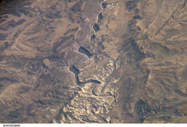
ISS015-E-28002 (12 Sept. 2007) --- A section of Dinosaur National Monument along the Yampa River in Colorado, which straddles the Colorado/Utah border, is featured in this image photographed by an Expedition 15 crewmember on the International Space Station. Dinosaur National Monument is perhaps best known for the abundant fossils found in the approximately 145 Ma (mega-annum, or millions of years old) Morrison Formation exposed in valleys and low ridges, according to scientists. The fossil assemblage is a unique record of terrestrial life of the period (dinosaurs, plants, and other animal species). Remains accumulated in streams and shallow lakes and were swiftly buried (and preserved) by sediments associated with those environments. Scientists believe these sediments in turn were lithified over many millions of years as they were buried under younger deposits -- forming the distinctive stratigraphy of the Monument. The generally flat-laying "layer cake" geology of the region -- similar to the Colorado Plateau to the south - is expressed in the image by parallel beds of tan, reddish-brown, and gray-brown sedimentary rocks cut by the Yampa River at the northern end of the Monument (top). Erosion by the Yampa River exposed the Morrison layer and its trove of fossil material. Together with other fossils found in both older and younger rock layers in the area, the Dinosaur National Monument remains an important scientific resource that continues to provide new insights into the geologic history and paleoecology of the region.Oblique View of Dinosaur National Monument:
In the northwest corner of Colorado, the west-flowing Yampa River meets the south-flowing Green River, which runs into Utah. Stretches of both river canyons upstream and downstream from the junction make up Dinosaur National Monument. The monument takes its name, of course, from the abundant fossils found in exposed valleys and low ridges of the Morrison Formation, a series of rock layers that were formed late in the Jurassic Period, roughly 145 million years ago.
This mosaic of four astronaut photographs (including ISS015-E-28001, ISS015-E-28002, ISS015-E-28003 & ISS015-E-28004) illustrates an approximately 47-kilometer (29-mile) section of the monument along the Yampa River in Colorado. The series of images was acquired while the International Space Station was over northeastern Nevada, about 480 kilometers (298 miles) to the west of the center of the mosaic. The oblique (taken from an angle, not straight down), eastward view provides a sense of topography due to shadows and perspective.
The generally flat-lying “layer cake” geology of the region—similar to the Colorado Plateau to the south—is evident in the parallel layers of tan, reddish-brown, and gray-brown sedimentary rocks cut by the Yampa River at the eastern end of the monument (image top). The river drops from a plateau, cutting into the exposed face of a long escarpment, and ripples west between two mountain ridges: Douglas Mountain to the north, and Blue Mountain to the south.
Erosion by the Yampa River in this rugged landscape exposed the Morrison Formation and its trove of fossil material, which includes not only dinosaurs but many other animals and plants. Millions of years ago, the remains of the living things—from bones to leaves—accumulated in streams and shallow lakes and were swiftly buried by clay, silt, and sand. These sediments were turned into rock over many millions of years as they were buried under newer sediments. The abundant fossils of the Morrison Formation, together with fossils that scientists have found in both older and younger rock layers in the area, make Dinosaur National Monument an important scientific resource that continues to provide new insights into the geologic history and ancient ecology of the region.
Download Packaged File.
This option downloads the following items, packaged into a single file, if they are available:
- Browse image
- Cataloged information with captions
- Camera file
- Sound file
Server: 2 |
This service is provided by the International Space Station program. |
Recommended Citation: |
||

