| Home >> | Advanced Search >> |
 |
|
Astronaut Photography of Earth - Display Record
ISS015-E-26171
Low-resolution Browse Image
(Most browse images are not color adjusted.)Images
Conditions for Use of Images >>Image Transformation Tutorial >> Saving, Color Adjusting, and Printing Images >>
Images to View on Your Computer Now
| File Name | File Size (bytes) | Width | Height | Annotated | Cropped | Purpose | Comments | |
|---|---|---|---|---|---|---|---|---|
| View | ISS015-E-26171.JPG | 66036 | 639 | 435 | No | No | ||
| View | ISS015-E-26171.JPG | 228596 | 540 | 357 | Yes | Yes | NASA's Earth Observatory web site |
Large Images to Request for Downloading
| File Name | File Size (bytes) | Width | Height | Annotated | Cropped | Purpose | Comments | |
|---|---|---|---|---|---|---|---|---|
| Request | ISS015-E-26171.JPG | 655561 | 1000 | 661 | No | Yes | NASA's Earth Observatory web site | |
| Request | ISS015-E-26171.JPG | 1155618 | 3032 | 2064 | No | No |
Download a Keyhole Markup Language (KML) file for use in Google Earth.
Electronic Image Data
Camera Files >> No sound file available.Identification
Mission: ISS015 Roll: E Frame: 26171 Mission ID on the Film or image: ISS015Country or Geographic Name: RUSSIAN FEDERATION
Features: SIMUSHIR I.,ZAVARITZKI VOLCANO
Center Point Latitude: 47.0 Center Point Longitude: 152.0 (Negative numbers indicate south for latitude and west for longitude)
Stereo: (Yes indicates there is an adjacent picture of the same area)
ONC Map ID: JNC Map ID:
Camera
Camera Tilt: 17Camera Focal Length: 180mm
Camera: E4: Kodak DCS760C Electronic Still Camera
Film: 3060E : 3060 x 2036 pixel CCD, RGBG array.
Quality
Film Exposure:Percentage of Cloud Cover: 50 (26-50)
Nadir
Date: 20070901 (YYYYMMDD)GMT Time: 231905 (HHMMSS)Nadir Point Latitude: 46.3, Longitude: 152.6 (Negative numbers indicate south for latitude and west for longitude)
Nadir to Photo Center Direction: Northwest
Sun Azimuth: 128 (Clockwise angle in degrees from north to the sun measured at the nadir point)
Spacecraft Altitude: 181 nautical miles (335 km)
Sun Elevation Angle: 40 (Angle in degrees between the horizon and the sun, measured at the nadir point)
Orbit Number: 2289
Captions
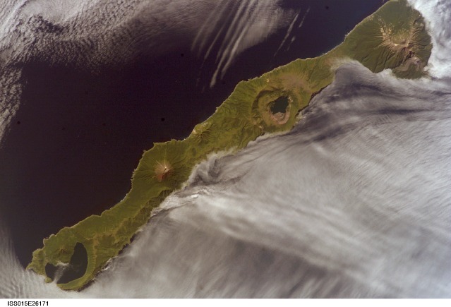
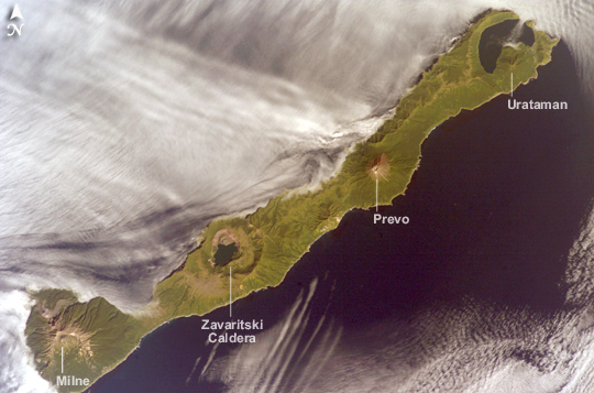
ISS015-E-26171 (1 Sept. 2007) --- Simushir Island, Kuril Archipelago, Russian Far East, is featured in this image photographed by an Expedition 15 crewmember on the International Space Station. Simushir is a deserted, 5-mile-wide volcanic island in the Kuril island chain, half way between northern Japan and the Kamchatka Peninsula of Russia. Four volcanoes - Milne, Prevo, Urataman and Zavaritski - have built cones that are high enough to rise above the altitude of green forest. The remaining remnant of Zavaritski volcano is a caldera -- a structure formed when a volcano collapses into its emptied magma chamber. A small lake fills the innermost of three nested calderas which make up Zavaritski Caldera. The larger caldera of Urataman Volcano is connected to the sea. A defunct Soviet naval base occupies the northern tip of the island next to this caldera. The islands and volcanoes of the Kuril chain are part of the Pacific Rim of Fire, marking the edge of the Pacific tectonic plate. Low stratus clouds approaching from the northwest (from the Sea of Okhotsk--top left) bank up against the northwest side of the island, making complex cloud patterns. A small finger of cloud can be seen entering the northernmost caldera (Urataman) at sea level. When this image was taken, the cloud layer had stopped at the northwest coast of the island, not flowing over even the low points of the island between the volcanoes. The cloud pattern suggests that the air mass flowed up and over the island, descending on the southeast side. This descending motion was enough--under stable atmospheric conditions--to warm up the atmosphere locally so that a cloud-free zone formed on the southeastern, lee side of the island.Simushir Island, Kuril Archipelago:
Simushir is a deserted, 5-mile-wide volcanic island in the Kuril Islands chain, half way between northern Japan and the Kamchatka Peninsula of Russia. Four volcanoes—Milne, Prevo, Urataman, and Zavaritski—have built cones tall enough to rise above the green forest. The remaining remnant of Zavaritski Volcano is a caldera, formed when a volcano collapses into its emptied magma chamber. A small lake fills the innermost of three nested calderas that make up Zavaritski Caldera. The larger caldera of Urataman Volcano is connected to the sea. The islands and volcanoes of the Kuril chain are part of the Pacific “Ring of Fire,” marking the edge of the Pacific tectonic plate.
Low stratus clouds approaching from the northwest (from the Sea of Okhotsk) bank against the northwest side of the island, forming complex cloud patterns. A small finger of cloud enters the northernmost caldera (Urataman) at sea level. When this image was taken, the cloud layer had stopped at the island’s northwest coast, not flowing over even the low points between the volcanoes. The cloud pattern suggests that an air mass flowed up and over the island, descending on the southeast side. When air rises, it often cools; water vapor in the air condenses into cloud droplets. When air sinks, it often warms, causing cloud droplets to evaporate. It appears that in this situation, the descending motion of the air warmed the atmosphere enough so that a cloud-free zone formed on the southeastern, lee side, of the island.
Download Packaged File.
This option downloads the following items, packaged into a single file, if they are available:
- Browse image
- Cataloged information with captions
- Camera file
- Sound file
Server: 2 |
This service is provided by the International Space Station program. |
Recommended Citation: |
||

