| Home >> | Advanced Search >> |
 |
|
Astronaut Photography of Earth - Display Record
ISS014-E-7480
Low-resolution Browse Image
(Most browse images are not color adjusted.)Images
Conditions for Use of Images >>Image Transformation Tutorial >> Saving, Color Adjusting, and Printing Images >>
Images to View on Your Computer Now
| File Name | File Size (bytes) | Width | Height | Annotated | Cropped | Purpose | Comments | |
|---|---|---|---|---|---|---|---|---|
| View | ISS014-E-7480.JPG | 81897 | 639 | 435 | No | No | ||
| View | ISS014-E-7480.JPG | 327282 | 540 | 381 | Yes | Yes | NASA's Earth Observatory web site |
Large Images to Request for Downloading
| File Name | File Size (bytes) | Width | Height | Annotated | Cropped | Purpose | Comments | |
|---|---|---|---|---|---|---|---|---|
| Request | ISS014-E-7480.JPG | 926558 | 1000 | 706 | No | Yes | NASA's Earth Observatory web site | |
| Request | ISS014-E-7480.JPG | 1175873 | 3032 | 2064 | No | No |
Download a Keyhole Markup Language (KML) file for use in Google Earth.
Electronic Image Data
Camera Files >> No sound file available.Identification
Mission: ISS014 Roll: E Frame: 7480 Mission ID on the Film or image: ISS014Country or Geographic Name: USA-TEXAS
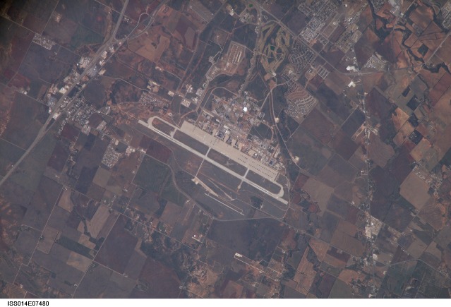
Features: DYESS AIR FORCE BASE, AGR.
Center Point Latitude: 32.4 Center Point Longitude: -99.8 (Negative numbers indicate south for latitude and west for longitude)
Stereo: (Yes indicates there is an adjacent picture of the same area)
ONC Map ID: JNC Map ID:
Camera
Camera Tilt: 19Camera Focal Length: 800mm
Camera: E4: Kodak DCS760C Electronic Still Camera
Film: 3060E : 3060 x 2036 pixel CCD, RGBG array.
Quality
Film Exposure:Percentage of Cloud Cover: 10 (0-10)
Nadir
Date: 20061107 (YYYYMMDD)GMT Time: 164854 (HHMMSS)Nadir Point Latitude: 32.7, Longitude: -100.8 (Negative numbers indicate south for latitude and west for longitude)
Nadir to Photo Center Direction: East
Sun Azimuth: 151 (Clockwise angle in degrees from north to the sun measured at the nadir point)
Spacecraft Altitude: 183 nautical miles (339 km)
Sun Elevation Angle: 36 (Angle in degrees between the horizon and the sun, measured at the nadir point)
Orbit Number: 1580
Captions
Dyess Air Force Base: Abilene, Texas:Dyess Air Force Base, located near the central Texas city of Abilene, is the home of the 7thBomb Wing and 317th Airlift Groups of the United States Air Force. The base also conducts all initial Air Force combat crew training for the B-1B Lancer aircraft. The main runway is approximately 5 kilometers long, a distance that is necessary to accommodate the large bombers and cargo aircraft at the base. Many of these aircraft are visible in the image, parked in parallel rows on the base tarmac.
Airfields and airports are useful sites for astronauts to hone their technique for using a long camera lens to acquire high-resolution images. The sharp contrast between highly reflective, linear features, such as runways, and darker agricultural fields and undisturbed (vegetated) land allows fine focusing of the cameras. This on-the-job training is crucial for teaching astronauts to obtain not only high-resolution imagery of Earth, but also inspection photographs of the thermal protection tiles on the Space Shuttle during continuing missions to the International Space Station.
Download Packaged File.
This option downloads the following items, packaged into a single file, if they are available:
- Browse image
- Cataloged information with captions
- Camera file
- Sound file
Server: 2 |
This service is provided by the International Space Station program. |
Recommended Citation: |
||

