| Home >> | Advanced Search >> |
 |
|
Astronaut Photography of Earth - Display Record
ISS013-E-76262
Low-resolution Browse Image
(Most browse images are not color adjusted.)Images
Conditions for Use of Images >>Image Transformation Tutorial >> Saving, Color Adjusting, and Printing Images >>
Images to View on Your Computer Now
| File Name | File Size (bytes) | Width | Height | Annotated | Cropped | Purpose | Comments | |
|---|---|---|---|---|---|---|---|---|
| View | ISS013-E-76262.JPG | 72887 | 639 | 435 | No | No | ||
| View | ISS013-E-76262.JPG | 507126 | 540 | 817 | Yes | Yes | NASA's Earth Observatory web site |
Large Images to Request for Downloading
| File Name | File Size (bytes) | Width | Height | Annotated | Cropped | Purpose | Comments | |
|---|---|---|---|---|---|---|---|---|
| Request | ISS013-E-76262.JPG | 1037561 | 3032 | 2064 | No | No | ||
| Request | ISS013-E-76262.JPG | 1300178 | 1000 | 1513 | No | Yes | NASA's Earth Observatory web site |
Download a Keyhole Markup Language (KML) file for use in Google Earth.
Electronic Image Data
Camera Files >> No sound file available.Identification
Mission: ISS013 Roll: E Frame: 76262 Mission ID on the Film or image: ISS013Country or Geographic Name: INDIA
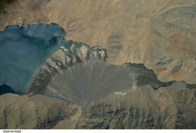
Features: L. TSO MORARI, ALLUVIAL FAN
Center Point Latitude: 32.8 Center Point Longitude: 78.3 (Negative numbers indicate south for latitude and west for longitude)
Stereo: (Yes indicates there is an adjacent picture of the same area)
ONC Map ID: JNC Map ID:
Camera
Camera Tilt: High ObliqueCamera Focal Length: 800mm
Camera: E4: Kodak DCS760C Electronic Still Camera
Film: 3060E : 3060 x 2036 pixel CCD, RGBG array.
Quality
Film Exposure:Percentage of Cloud Cover: 10 (0-10)
Nadir
Date: 20060904 (YYYYMMDD)GMT Time: 071530 (HHMMSS)Nadir Point Latitude: 36.2, Longitude: 82.9 (Negative numbers indicate south for latitude and west for longitude)
Nadir to Photo Center Direction: Southwest
Sun Azimuth: 204 (Clockwise angle in degrees from north to the sun measured at the nadir point)
Spacecraft Altitude: 184 nautical miles (341 km)
Sun Elevation Angle: 59 (Angle in degrees between the horizon and the sun, measured at the nadir point)
Orbit Number: 564
Captions
Lake Morari, Tibet:Meltwater from glaciers to the east and west drains into Lake Morari, a large lake that lies at an altitude of 4,521 meters (14,830 feet) on the Tibetan Plateau. A stream on the west side provides the lake’s main inflow. Mud from this river gives the light blue hues to the lake water. The well-formed alluvial fan (image center), built by sediment from the main inflow river, is the reason the lake has formed at this point in the valley. The fan has dammed up the depression now occupied by Lake Morari, which is approximately 7 kilometers (4 miles) wide in this view. The fan forms the curved southern shore of the lake. The apex of the fan lies fully 40 meters (130 feet) above the level of the lake. The change of color and texture on the fan appears to result from a new influx of gray sediment on top of an older fan that had been carved by several channels.
Interestingly, the alluvial fan also acts as the only outlet of the lake, although no obvious outlet channel can be seen in this detailed astronaut photograph captured on September 4, 2006. South of the fan, an outlet river appears as a green surface, possibly due to aquatic vegetation or algae. Altitude measurements show that the outlet river lies many meters below the lake surface. This means that lake water drains slowly through the permeable sediments of the alluvial fan by subsurface flow, roughly following the line of the arrow. Another, smaller alluvial fan in the south constricts this outlet river.
Download Packaged File.
This option downloads the following items, packaged into a single file, if they are available:
- Browse image
- Cataloged information with captions
- Camera file
- Sound file
Server: 2 |
This service is provided by the International Space Station program. |
Recommended Citation: |
||

