| Home >> | Advanced Search >> |
 |
|
Astronaut Photography of Earth - Display Record
ISS011-E-12547

Low-resolution Browse Image
(Most browse images are not color adjusted.)Images
Conditions for Use of Images >>Image Transformation Tutorial >> Saving, Color Adjusting, and Printing Images >>
Images to View on Your Computer Now
| File Name | File Size (bytes) | Width | Height | Annotated | Cropped | Purpose | Comments | |
|---|---|---|---|---|---|---|---|---|
| View | ISS011-E-12547.JPG | 92332 | 639 | 435 | No | No | ||
| View | ISS011-E-12547.JPG | 302201 | 540 | 356 | Yes | Yes | NASA's Earth Observatory web site |
Large Images to Request for Downloading
| File Name | File Size (bytes) | Width | Height | Annotated | Cropped | Purpose | Comments | |
|---|---|---|---|---|---|---|---|---|
| Request | ISS011-E-12547.JPG | 904015 | 1000 | 660 | No | Yes | NASA's Earth Observatory web site | |
| Request | ISS011-E-12547.JPG | 1345416 | 3032 | 2008 | No | No | Not enhanced | Converted to JPEG from a raw image |
Download a Keyhole Markup Language (KML) file for use in Google Earth.
Electronic Image Data
Camera Files >> No sound file available.Identification
Mission: ISS011 Roll: E Frame: 12547 Mission ID on the Film or image: ISS011Country or Geographic Name: USA-MISSISSIPPI
Features: BILOXI, OCEAN SPRINGS, BACK B.
Center Point Latitude: 30.4 Center Point Longitude: -88.9 (Negative numbers indicate south for latitude and west for longitude)
Stereo: (Yes indicates there is an adjacent picture of the same area)
ONC Map ID: JNC Map ID:
Camera
Camera Tilt: 27Camera Focal Length: 400mm
Camera: E4: Kodak DCS760C Electronic Still Camera
Film: 3060E : 3060 x 2036 pixel CCD, RGBG array.
Quality
Film Exposure:Percentage of Cloud Cover: 10 (0-10)
Nadir
Date: 20050908 (YYYYMMDD)GMT Time: 212204 (HHMMSS)Nadir Point Latitude: 31.3, Longitude: -87.6 (Negative numbers indicate south for latitude and west for longitude)
Nadir to Photo Center Direction: Southwest
Sun Azimuth: 254 (Clockwise angle in degrees from north to the sun measured at the nadir point)
Spacecraft Altitude: 187 nautical miles (346 km)
Sun Elevation Angle: 34 (Angle in degrees between the horizon and the sun, measured at the nadir point)
Orbit Number: 2885
Captions
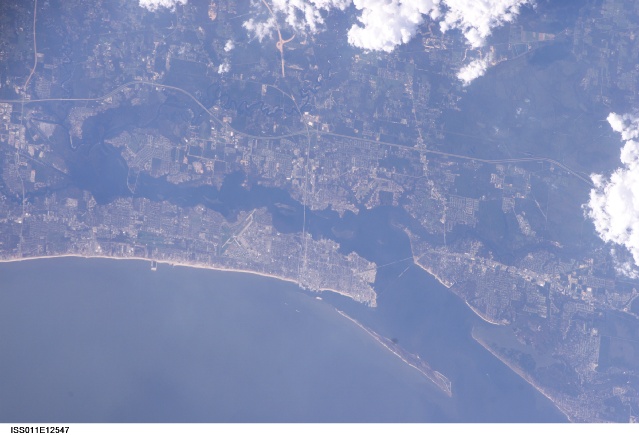
Hurricane Damage in Biloxi, MississippiThe port town of Biloxi, Mississippi experienced significant damage when Hurricane Katrina came ashore on August 29, 2005. Biloxi was established in 1838 following Mississippi statehood in 1817. The town was a favorite vacation destination for other Gulf Coast cities, particularly New Orleans, throughout the 19th and 20th centuries. Keesler Air Force Base was established in Biloxi in 1947; the runways are visible to the west of the downtown area in the top image. The legalization of dockside gambling and casinos in 1992 helped to invigorate the town’s economy, but many of the casinos were severely damaged by the hurricane.
Katrina isn’t the first hurricane to strike Biloxi during its 280-year history. Several hurricanes have battered the town, but the most powerful prior to Katrina was Hurricane Camille in 1969. The astronaut photograph (top) illustrates damage and flooding in the Biloxi area caused by Hurricane Katrina. A Landsat Enhanced Thematic Mapper Plus image (bottom), acquired in 2000, provides a base for comparison. Damage to the 2.5 kilometer (1.6 mile) long US-90 bridge is evident in the astronaut photograph—the bridge is almost completely destroyed with only two sections of roadbed still intact. Flooded areas are indicated by dark greenish-brown coloration along river courses to the northeast and northwest of downtown. Most of the flood water remains within the rivers’ floodplains, which are defined by reddish-brown sediment in the Landsat image.
Download Packaged File.
This option downloads the following items, packaged into a single file, if they are available:
- Browse image
- Cataloged information with captions
- Camera file
- Sound file
Server: 2 |
This service is provided by the International Space Station program. |
Recommended Citation: |
||

