| Home >> | Advanced Search >> |
 |
|
Astronaut Photography of Earth - Display Record
ISS008-E-8951
Low-resolution Browse Image
(Most browse images are not color adjusted.)Images
Conditions for Use of Images >>Image Transformation Tutorial >> Saving, Color Adjusting, and Printing Images >>
Images to View on Your Computer Now
| File Name | File Size (bytes) | Width | Height | Annotated | Cropped | Purpose | Comments | |
|---|---|---|---|---|---|---|---|---|
| View | ISS008-E-8951.JPG | 21092 | 639 | 437 | No | No | ||
| View | ISS008-E-8951.JPG | 63364 | 540 | 540 | No | Yes | NASA's Earth Observatory web site | |
| View | ISS008-E-8951.JPG | 172381 | 540 | 677 | No | Yes | NASA's Earth Observatory web site | color adjusted |
| View | ISS008-E-8951.JPG | 537140 | 1000 | 1529 | No | No | NASA's Earth Observatory web site | color adjusted |
Large Images to Request for Downloading
| File Name | File Size (bytes) | Width | Height | Annotated | Cropped | Purpose | Comments | |
|---|---|---|---|---|---|---|---|---|
| Request | ISS008-E-8951_2.JPG | 116636 | 656 | 1000 | No | No | NASA's Earth Observatory web site | |
| Request | ISS008-E-8951.JPG | 251190 | 2000 | 1368 | No | No | ||
| Request | ISS008-E-8951.JPG | 851049 | 1308 | 2000 | No | No | Earth From Space collection | color adjusted |
| Request | ISS008-E-8951.TIF | 7932238 | 2000 | 1312 | No | No | Original file from camera |
Download a Keyhole Markup Language (KML) file for use in Google Earth.
Electronic Image Data
Camera Files >> No sound file available.Identification
Mission: ISS008 Roll: E Frame: 8951 Mission ID on the Film or image: ISS008Country or Geographic Name: ASTRONOMICAL OBJECTS
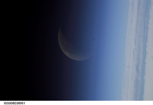
Features: PAN-CRESCENT MOON, EARTH LIMB
Center Point Latitude: Center Point Longitude: (Negative numbers indicate south for latitude and west for longitude)
Stereo: (Yes indicates there is an adjacent picture of the same area)
ONC Map ID: JNC Map ID:
Camera
Camera Tilt: High ObliqueCamera Focal Length: 800mm
Camera: N1: Nikon D1
Film: 2000E : 2000 x 1312 pixel CCD, RGBG imager color filter.
Quality
Film Exposure:Percentage of Cloud Cover: 25 (11-25)
Nadir
Date: 20031218 (YYYYMMDD)GMT Time: 154429 (HHMMSS)Nadir Point Latitude: 38.9, Longitude: -13.3 (Negative numbers indicate south for latitude and west for longitude)
Nadir to Photo Center Direction: South
Sun Azimuth: 221 (Clockwise angle in degrees from north to the sun measured at the nadir point)
Spacecraft Altitude: 199 nautical miles (369 km)
Sun Elevation Angle: 16 (Angle in degrees between the horizon and the sun, measured at the nadir point)
Orbit Number: 984
Captions
Thinning Upper Atmosphere:From a vantage point about 360 km (225 miles) over the Earth, Space Station crewmembers photographed the crescent moon through the upper layers of Earth’s atmosphere. At the bottom of the image, a closed deck of clouds is probably at about 6 km (3 miles). The shades of blue grading to black are caused by the scatter of light as it strikes gas molecules of the very low density upper atmosphere.
Models predict that emissions of carbon dioxide are causing the upper atmosphere to cool and contract, and therefore reduce the density of gases in the layer spanning from 90 to 649 km (60 to 400 miles) above the surface—known as the thermosphere. According to a study by the Naval Research Laboratory (http://www.agu.org/sci_soc/prrl/prrl0406.html), the density of the thermosphere has decreased about 10 percent over the last 35 years. These findings are important both for space science and for Earth science. Spacecraft in orbit, such as the International Space Station, experience less drag and need fewer boosts to maintain their orbit. At the same time, space debris also remains in orbit longer, which increases hazards to spacecraft. Most importantly, the study validates models of the “greenhouse effect” of increased carbon dioxide release on the dynamics of the atmosphere.
Download Packaged File.
This option downloads the following items, packaged into a single file, if they are available:
- Browse image
- Cataloged information with captions
- Camera file
- Sound file
Server: 2 |
This service is provided by the International Space Station program. |
Recommended Citation: |
||

