| Home >> | Advanced Search >> |
 |
|
Astronaut Photography of Earth - Display Record
ISS007-E-7360
Low-resolution Browse Image
(Most browse images are not color adjusted.)Images
Conditions for Use of Images >>Image Transformation Tutorial >> Saving, Color Adjusting, and Printing Images >>
Images to View on Your Computer Now
| File Name | File Size (bytes) | Width | Height | Annotated | Cropped | Purpose | Comments | |
|---|---|---|---|---|---|---|---|---|
| View | ISS007-E-7360.JPG | 75000 | 354 | 540 | Photographic Highlights | (resized 540 px images) | ||
| View | ISS007-E-7360.JPG | 98439 | 639 | 435 | No | No | ||
| View | ISS007-E-7360_2.JPG | 152533 | 503 | 768 | Photographic Highlights | (actual files used) | ||
| View | ISS007-E-7360.JPG | 165957 | 540 | 819 | Yes | Yes | NASA's Earth Observatory web site | |
| View | ISS007-E-7360.JPG | 165957 | 540 | 819 | Yes | Yes | NASA's Earth Observatory web site | Color adjusted |
| View | ISS007-E-7360_2.JPG | 275094 | 540 | 393 | Yes | Yes | NASA's Earth Observatory web site | |
| View | ISS007-E-7360.JPG | 2187371 | 1000 | 1516 | No | Yes | NASA's Earth Observatory web site | Color adjusted |
Large Images to Request for Downloading
| File Name | File Size (bytes) | Width | Height | Annotated | Cropped | Purpose | Comments | |
|---|---|---|---|---|---|---|---|---|
| Request | ISS007-E-7360.JPG | 1483292 | 3032 | 2064 | No | No | ||
| Request | ISS007-E-7360_2.JPG | 6798635 | 6144 | 4068 | No | No | Presentation | Earth Sciences Results Briefing/Ed Lu |
Download a Keyhole Markup Language (KML) file for use in Google Earth.
Electronic Image Data
Camera Files >> No sound file available.Identification
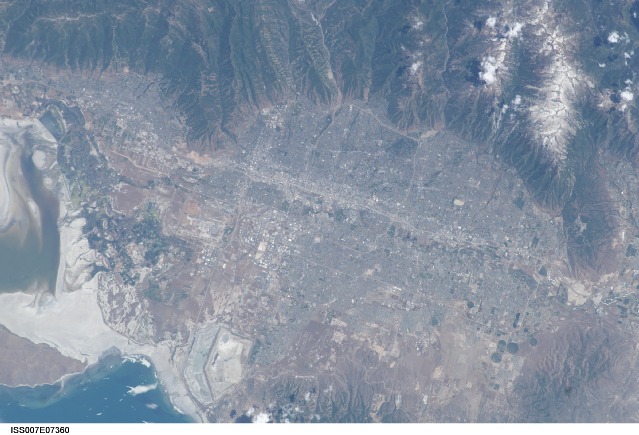
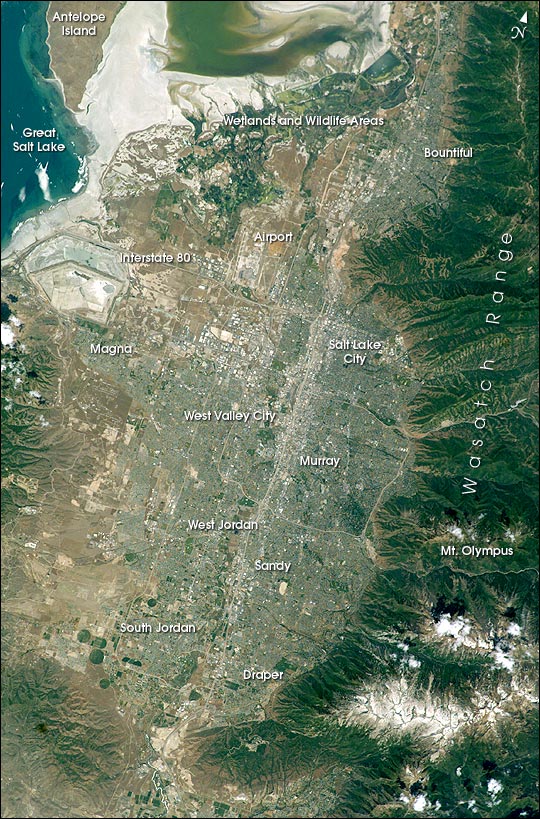
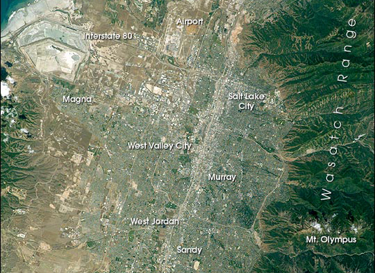
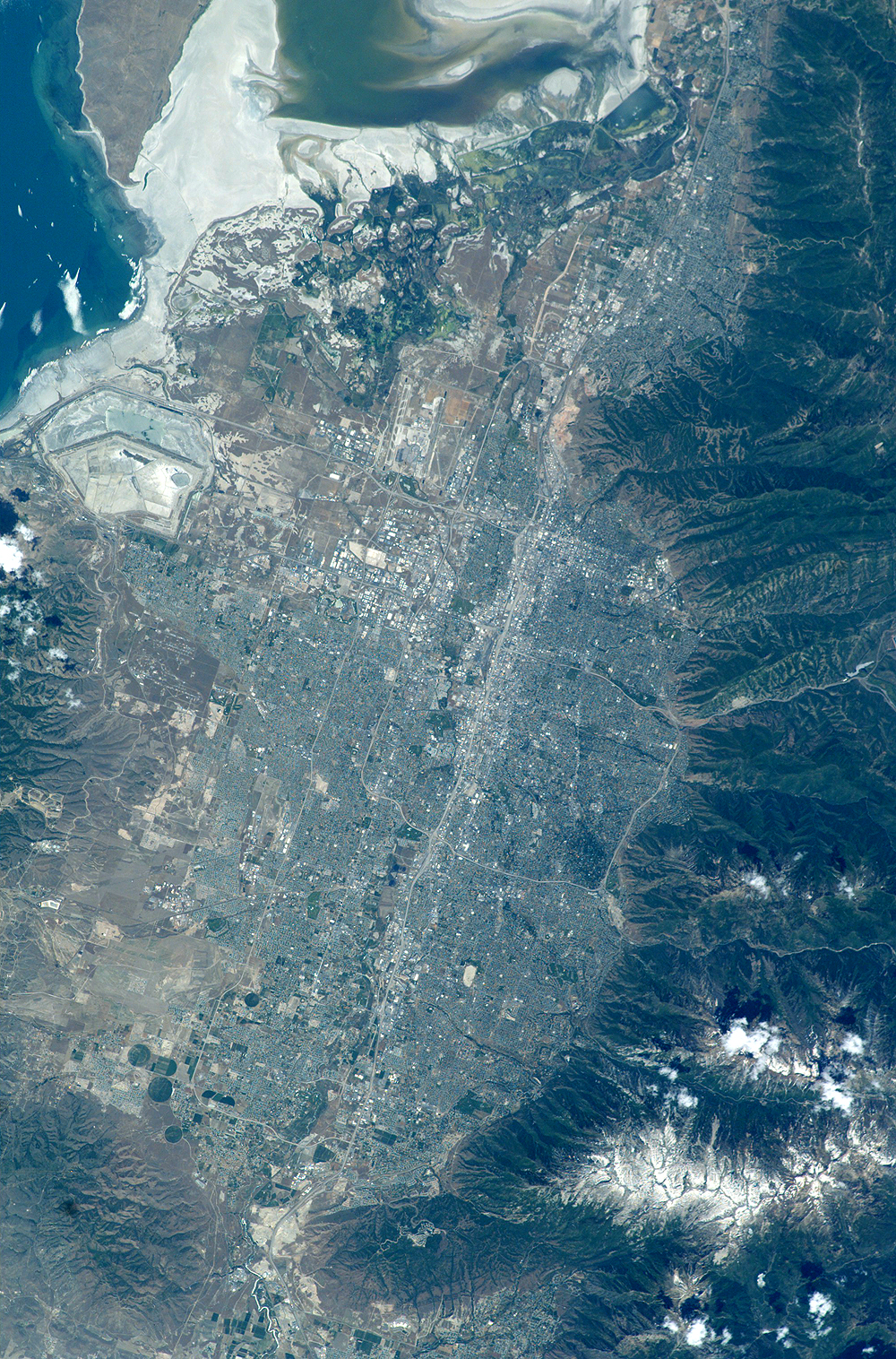
Mission: ISS007 Roll: E Frame: 7360 Mission ID on the Film or image: ISS007Country or Geographic Name: USA-UTAH
Features: SALT LAKE CITY, BOUNTIFUL
Center Point Latitude: 40.5 Center Point Longitude: -112.0 (Negative numbers indicate south for latitude and west for longitude)
Stereo: (Yes indicates there is an adjacent picture of the same area)
ONC Map ID: JNC Map ID:
Camera
Camera Tilt: 17Camera Focal Length: 180mm
Camera: E4: Kodak DCS760C Electronic Still Camera
Film: 3060E : 3060 x 2036 pixel CCD, RGBG array.
Quality
Film Exposure:Percentage of Cloud Cover: 10 (0-10)
Nadir
Date: 20030614 (YYYYMMDD)GMT Time: 190324 (HHMMSS)Nadir Point Latitude: 41.2, Longitude: -112.8 (Negative numbers indicate south for latitude and west for longitude)
Nadir to Photo Center Direction: Southeast
Sun Azimuth: 160 (Clockwise angle in degrees from north to the sun measured at the nadir point)
Spacecraft Altitude: 209 nautical miles (387 km)
Sun Elevation Angle: 71 (Angle in degrees between the horizon and the sun, measured at the nadir point)
Orbit Number: 2063
Captions
The regional environmental impact of urban sprawl around fast-growing cities can be documented and monitored from space. As an example, Salt Lake City, Utah, has experienced rapid population growth over the last 10 years.This regional view of Salt Lake City, photographed on 14 June 2003 from the International Space Station, shows the city and its suburbs nestled between the Wasatch Front and the Great Salt Lake. Interstate Highway 15 runs North-South through the valley, with suburbs arrayed east and west of the highway (annotated on the image). A photograph like this one helps in visualizing the trade-offs between urban, agricultural, and wildlife uses of water in a desert environment.
An important issue facing Salt Lake City’s growing population is preservation and allocation of water resources. Utah is in its fifth year of drought. One of the most dramatic effects of the drought visible in this picture is the fact that the lake levels are so low that Antelope Island is separated from the mainland by dry lakebed. This year it is so dry that it is possible to walk on the mudflat. The level of the Great Salt Lake has dropped more than 7 feet since the drought began in 1999.
Expansive, productive wetlands occur where freshwater flows from the Wasatch Range and into the lake. The southern end of this network of wetlands can be seen in the image. The Great Salt Lake Wetland Ecosystem is recognized as being of hemispheric importance by the Western Hemisphere Shorebird Reserve Network and has been nominated for inclusion on the Ramsar Convention on Wetlands’ list of Wetlands of International Significance.
Images of cities taken from the International Space Station are one of the science themes for the Crew Earth Observations Project. Astronauts take detailed views using long lenses that show roads and major buildings and synoptic views, like this one, that show the entire urban area with suburbs and surrounding lands in a single field of view.
Download Packaged File.
This option downloads the following items, packaged into a single file, if they are available:
- Browse image
- Cataloged information with captions
- Camera file
- Sound file
Server: 2 |
This service is provided by the International Space Station program. |
Recommended Citation: |
||

