| Home >> | Advanced Search >> |
 |
|
Astronaut Photography of Earth - Display Record
ISS005-E-20451

Low-resolution Browse Image
(Most browse images are not color adjusted.)Images
Conditions for Use of Images >>Image Transformation Tutorial >> Saving, Color Adjusting, and Printing Images >>
Images to View on Your Computer Now
| File Name | File Size (bytes) | Width | Height | Annotated | Cropped | Purpose | Comments | |
|---|---|---|---|---|---|---|---|---|
| View | ISS005-E-20451.JPG | 74691 | 540 | 540 | Yes | Yes | NASA's Earth Observatory web site | |
| View | ISS005-E-20451.JPG | 85690 | 639 | 435 | No | No | From STIC, color adjusted | |
| View | ISS005-E-20451.JPG | 238555 | 352 | 540 | Photographic Highlights | (540 px resized images) | ||
| View | ISS005-E-20451.JPG | 436965 | 1000 | 1504 | No | No | NASA's Earth Observatory web site | |
| View | ISS005-E-20451_2.JPG | 448510 | 501 | 768 | Photographic Highlights | (actual files used) |
Large Images to Request for Downloading
| File Name | File Size (bytes) | Width | Height | Annotated | Cropped | Purpose | Comments | |
|---|---|---|---|---|---|---|---|---|
| Request | ISS005-E-20451.JPG | 1304543 | 3032 | 2064 | No | No | From STIC, color adjusted |
Download a Keyhole Markup Language (KML) file for use in Google Earth.
Electronic Image Data
Camera Files >> No sound file available.Identification
Mission: ISS005 Roll: E Frame: 20451 Mission ID on the Film or image: ISS005Country or Geographic Name: CHAD
Features: EMI KOUSSI, CRATER DETAIL
Center Point Latitude: 20.0 Center Point Longitude: 18.5 (Negative numbers indicate south for latitude and west for longitude)
Stereo: (Yes indicates there is an adjacent picture of the same area)
ONC Map ID: JNC Map ID:
Camera
Camera Tilt: 31Camera Focal Length: 800mm
Camera: E4: Kodak DCS760C Electronic Still Camera
Film: 3060E : 3060 x 2036 pixel CCD, RGBG array.
Quality
Film Exposure:Percentage of Cloud Cover: 10 (0-10)
Nadir
Date: 20021111 (YYYYMMDD)GMT Time: 082600 (HHMMSS)Nadir Point Latitude: 20.0, Longitude: 20.6 (Negative numbers indicate south for latitude and west for longitude)
Nadir to Photo Center Direction: West
Sun Azimuth: 141 (Clockwise angle in degrees from north to the sun measured at the nadir point)
Spacecraft Altitude: 206 nautical miles (382 km)
Sun Elevation Angle: 43 (Angle in degrees between the horizon and the sun, measured at the nadir point)
Orbit Number: 2702
Captions
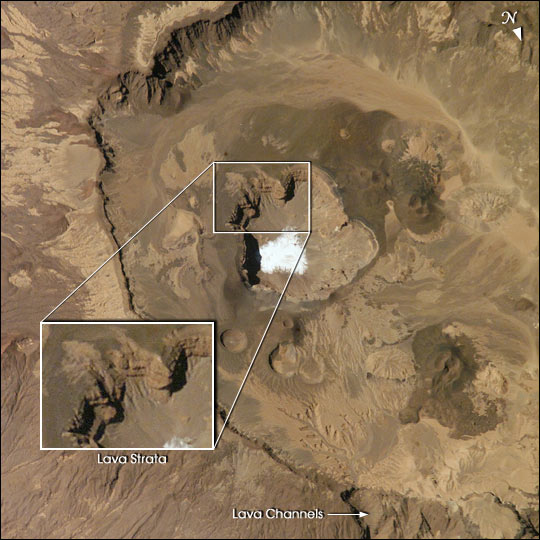
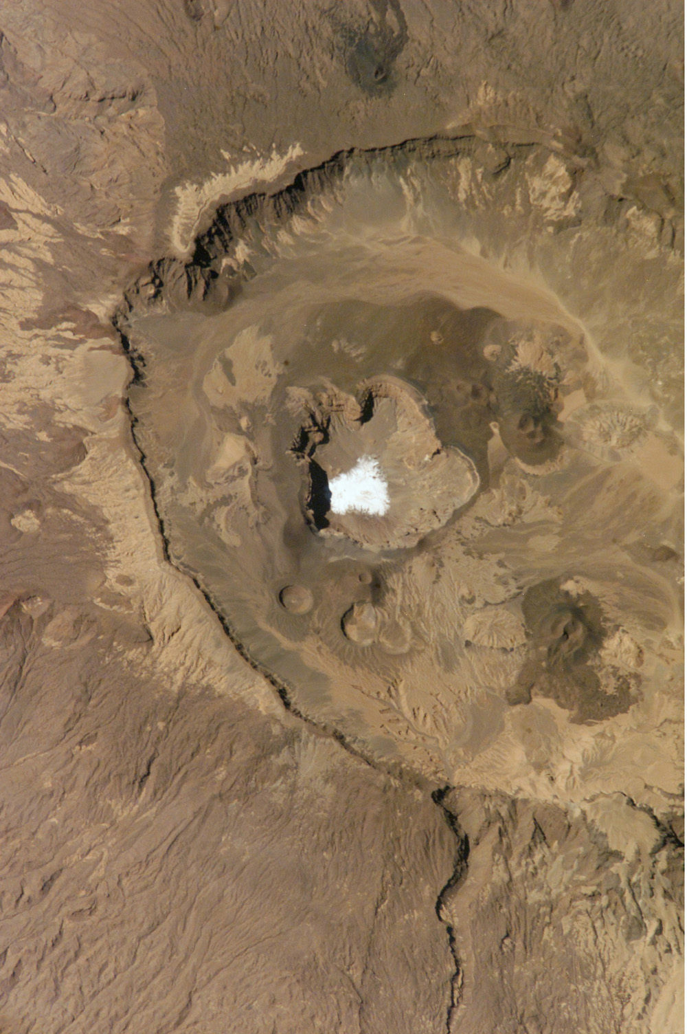
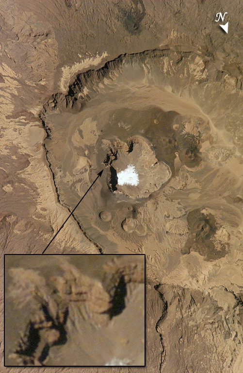
Emi Koussi is a high volcano that lies at the south end of the Tibesti Mountains in the central Sahara in northern Chad. The volcano is one of several in the Tibesti massif, and reaches 3415 m in altitude, rising 2.3 km above the surrounding sandstone plains. The volcano is 65 km wide.This view of the Emi Koussi caldera was taken with an 800 mm lens on November 21, 2002. It is detailed to the point that it doesn’t include the entire 10-km diameter of the caldera, but reveals individual lava strata within the walls of the summit cliffs. Nested within the main caldera is a smaller crater that contains white salts of a dry lake at its lowest point. Here too, strata are visible in the walls of the smaller crater. The smaller crater is surrounded by a region of darker rocks—a geologically young dome of lava studded with several small circular volcanic vents.
Emi Koussi has been used as a close analog to the famous Martian volcano Elysium Mons (http://www.msss.com/mars_images/moc/7_10_98_elysium_rel/). One of the most important morphological differences between volcanoes on Mars and Earth is the widespread furrowing of the surface due to flowing water on terrestrial volcanoes. The furrows are shallow valleys. Larger channels have a different origin. Major channels can be seen on volcanoes on both planets and indicate low points in caldera rims where lava spilled out of pre-collapse craters.
Download Packaged File.
This option downloads the following items, packaged into a single file, if they are available:
- Browse image
- Cataloged information with captions
- Camera file
- Sound file
Server: 2 |
This service is provided by the International Space Station program. |
Recommended Citation: |
||

