| Home >> | Advanced Search >> |
 |
|
Astronaut Photography of Earth - Display Record
ISS005-E-15906

Low-resolution Browse Image
(Most browse images are not color adjusted.)Images
Conditions for Use of Images >>Image Transformation Tutorial >> Saving, Color Adjusting, and Printing Images >>
Images to View on Your Computer Now
| File Name | File Size (bytes) | Width | Height | Annotated | Cropped | Purpose | Comments | |
|---|---|---|---|---|---|---|---|---|
| View | ISS005-E-15906.JPG | 40984 | 639 | 435 | No | No | From STIC, color adjusted | |
| View | ISS005-E-15906.JPG | 162433 | 540 | 340 | Photographic Highlights | (540 px resized images) | ||
| View | ISS005-E-15906.JPG | 252050 | 1000 | 657 | No | Yes | NASA's Earth Observatory web site |
Large Images to Request for Downloading
| File Name | File Size (bytes) | Width | Height | Annotated | Cropped | Purpose | Comments | |
|---|---|---|---|---|---|---|---|---|
| Request | ISS005-E-15906.JPG | 534736 | 1024 | 644 | Photographic Highlights | (actual files used) | ||
| Request | ISS005-E-15906.JPG | 1156232 | 3032 | 2064 | No | No | From STIC, color adjusted |
Download a Keyhole Markup Language (KML) file for use in Google Earth.
Electronic Image Data
Camera Files >> No sound file available.Identification
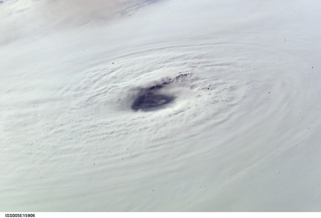
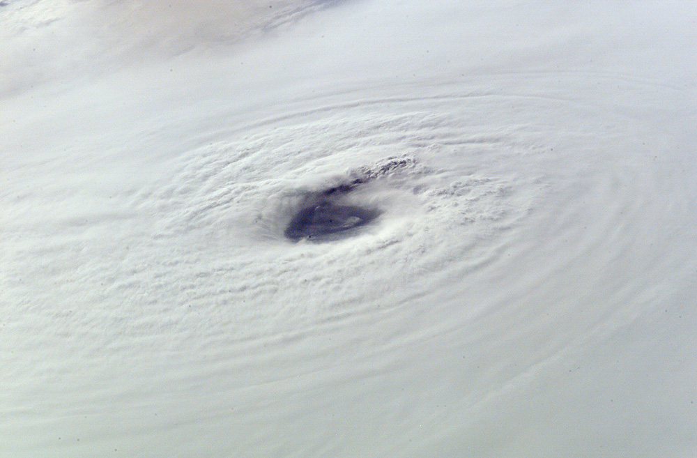
Mission: ISS005 Roll: E Frame: 15906 Mission ID on the Film or image: ISS005Country or Geographic Name: GULF OF MEXICO
Features: EYE OF HURRICANE LILI
Center Point Latitude: 26.0 Center Point Longitude: -90.0 (Negative numbers indicate south for latitude and west for longitude)
Stereo: (Yes indicates there is an adjacent picture of the same area)
ONC Map ID: JNC Map ID:
Camera
Camera Tilt: High ObliqueCamera Focal Length: 200mm
Camera: E4: Kodak DCS760C Electronic Still Camera
Film: 3060E : 3060 x 2036 pixel CCD, RGBG array.
Quality
Film Exposure:Percentage of Cloud Cover: 100 (76-100)
Nadir
Date: 20021002 (YYYYMMDD)GMT Time: 213731 (HHMMSS)Nadir Point Latitude: 25.4, Longitude: -81.8 (Negative numbers indicate south for latitude and west for longitude)
Nadir to Photo Center Direction: West
Sun Azimuth: 255 (Clockwise angle in degrees from north to the sun measured at the nadir point)
Spacecraft Altitude: 204 nautical miles (378 km)
Sun Elevation Angle: 20 (Angle in degrees between the horizon and the sun, measured at the nadir point)
Orbit Number: 2087
Captions
On October 2, 2002, Houston’s Mission Control Center powered down and people along the coasts of Texas and Louisiana prepared for landfall of Hurricane Lili. The storm held special significance for International Space Station astronauts orbiting above 210 n. mi. above—it delayed that day’s launch of the Space Shuttle that was scheduled to bring them visitors and supplies and hardware. However, the crew gained perspective on Lili by tracking and photographing the hurricane near its peak. Early in the day, the storm strengthened rapidly from a strong Category 2 (at 7 AM CDT Oct. 2, maximum winds were near 95 knots with a central pressure of 954 millibars) to a robust Category 4 Hurricane (125 knots with the central pressure of 940 millibars). Fortunately the storm weakened to a Category 2 Hurricane again prior to landfall about twelve hours later on the marshy, uninhabited coast of central Louisiana south of Lafayette.In successive late afternoon orbits, the astronauts viewed the storm in the northern Gulf of Mexico and acquired these dramatic digital photos of Lili’s compact storm system along with details of the structure of its estimated 15 nautical mile wide eye. During this interval, the storm continued to intensify. The first pair of photos (left) were taken at 4:37 PM CDT. At 4 PM CDT Hurricane Hunter aircraft had estimated 120 knot winds. The pair of images on the right were taken 1 orbit later, at 6:13 PM CDT—the darker, bluer color results from lower sun angles. At 7 PM the Hurricane Hunter estimated the wind speeds at 125 knots These oblique views with low sun provide details and perspectives of such storms unavailable from meteorological satellite systems.
Link to Earth Observatory Caption >>
Download Packaged File.
This option downloads the following items, packaged into a single file, if they are available:
- Browse image
- Cataloged information with captions
- Camera file
- Sound file
Server: 2 |
This service is provided by the International Space Station program. |
Recommended Citation: |
||

