| Home >> | Advanced Search >> |
 |
|
Astronaut Photography of Earth - Display Record
ISS004-E-11807
Low-resolution Browse Image
(Most browse images are not color adjusted.)Images
Conditions for Use of Images >>Image Transformation Tutorial >> Saving, Color Adjusting, and Printing Images >>
Images to View on Your Computer Now
| File Name | File Size (bytes) | Width | Height | Annotated | Cropped | Purpose | Comments | |
|---|---|---|---|---|---|---|---|---|
| View | ISS004-E-11807.JPG | 85159 | 540 | 426 | Yes | Yes | NASA's Earth Observatory web site | |
| View | ISS004-E-11807.JPG | 103802 | 639 | 435 | No | No | From STIC, color adjusted | |
| View | ISS004-E-11807.JPG | 316270 | 540 | 427 | Photographic Highlights | 540 px resized images | ||
| View | ISS004-E-11807.JPG | 1129924 | 1000 | 790 | No | Yes | NASA's Earth Observatory web site |
Large Images to Request for Downloading
| File Name | File Size (bytes) | Width | Height | Annotated | Cropped | Purpose | Comments | |
|---|---|---|---|---|---|---|---|---|
| Request | ISS004-E-11807.JPG | 1101095 | 1000 | 790 | Photographic Highlights | actual files used | ||
| Request | ISS004-E-11807.JPG | 1524905 | 3032 | 2064 | No | No | From STIC, color adjusted |
Download a Keyhole Markup Language (KML) file for use in Google Earth.
Electronic Image Data
Camera Files >> No sound file available.Identification
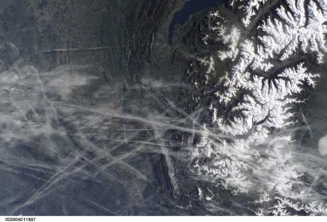
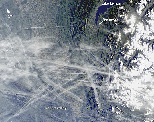
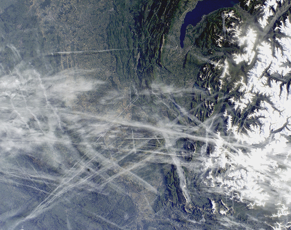
Mission: ISS004 Roll: E Frame: 11807 Mission ID on the Film or image: ISS004Country or Geographic Name: FRANCE
Features: RHONE VALLEY, ALPS, CONTRAILS
Center Point Latitude: 46.0 Center Point Longitude: 6.0 (Negative numbers indicate south for latitude and west for longitude)
Stereo: (Yes indicates there is an adjacent picture of the same area)
ONC Map ID: JNC Map ID:
Camera
Camera Tilt: 30Camera Focal Length: 35mm
Camera: E4: Kodak DCS760C Electronic Still Camera
Film: 3060E : 3060 x 2036 pixel CCD, RGBG array.
Quality
Film Exposure:Percentage of Cloud Cover: 10 (0-10)
Nadir
Date: 20020515 (YYYYMMDD)GMT Time: 064443 (HHMMSS)Nadir Point Latitude: 46.6, Longitude: 7.9 (Negative numbers indicate south for latitude and west for longitude)
Nadir to Photo Center Direction: West
Sun Azimuth: 91 (Clockwise angle in degrees from north to the sun measured at the nadir point)
Spacecraft Altitude: 204 nautical miles (378 km)
Sun Elevation Angle: 27 (Angle in degrees between the horizon and the sun, measured at the nadir point)
Orbit Number: 3909
Captions
This digital photograph taken through the windows of the International Space Station on May 15, 2002, shows condensation trails over the Rhône Valley in the region west of Lyon. Condensation trails—or contrails—are straight lines of ice crystals that form in the wake of jet liners where air temperatures at altitude are lower than about –40°C.Newer contrails are thin whereas older trails have widened with time as a result of light winds. Because of this tendency for thin contrails to cover greater areas with time, it is estimated that these “artificial clouds” cover 0.1% of the planet’s surface. Percentages are far higher in some places such as southern California, the Ohio River Valley and parts of Europe, as illustrated here.
The climatic impact of such clouds is poorly understood. In an unprecedented experiment following the September 11 grounding of all aircraft in the United States, researchers reported in the August 8 issue of Nature that temperatures in areas usually affected by contrail blankets fluctuated higher and lower during the contrail-free period. Despite this dramatic conclusion, it is nevertheless too early to know whether contrails produce a net warming or cooling of the atmosphere. Whereas cirrus clouds seem to have a net warming effect, contrails are denser and thus may produce the opposite effect.
References:
Travis, D. J., Carleton, A. M. and R. G. Lauritsen. 2002. Contrails reduce daily temperature range. Nature 418:601.
9/11 study: Air traffic affects climate (CNN) (http://www.cnn.com/2002/TECH/science/08/07/contrails.climate/index.html)
Download Packaged File.
This option downloads the following items, packaged into a single file, if they are available:
- Browse image
- Cataloged information with captions
- Camera file
- Sound file
Server: 2 |
This service is provided by the International Space Station program. |
Recommended Citation: |
||

