| Home >> | Advanced Search >> |
 |
|
Astronaut Photography of Earth - Display Record
ISS011-E-9913

Low-resolution Browse Image
(Most browse images are not color adjusted.)Images
Conditions for Use of Images >>Image Transformation Tutorial >> Saving, Color Adjusting, and Printing Images >>
Images to View on Your Computer Now
| File Name | File Size (bytes) | Width | Height | Annotated | Cropped | Purpose | Comments | |
|---|---|---|---|---|---|---|---|---|
| View | ISS011-E-9913.JPG | 109225 | 640 | 428 | No | No | ||
| View | ISS011-E-9913.JPG | 305321 | 540 | 352 | Yes | Yes | NASA's Earth Observatory web site |
Large Images to Request for Downloading
| File Name | File Size (bytes) | Width | Height | Annotated | Cropped | Purpose | Comments | |
|---|---|---|---|---|---|---|---|---|
| Request | ISS011-E-9913.JPG | 285103 | 3008 | 1960 | No | No | Not enhanced | Converted to JPEG from a raw image |
| Request | ISS011-E-9913.JPG | 958800 | 1000 | 651 | No | Yes | NASA's Earth Observatory web site |
Download a Keyhole Markup Language (KML) file for use in Google Earth.
Electronic Image Data
Camera Files >> No sound file available.Identification
Mission: ISS011 Roll: E Frame: 9913 Mission ID on the Film or image: ISS011Country or Geographic Name: RUSSIAN FEDERATION
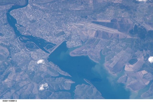
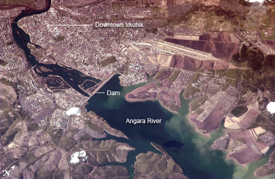
Features: IRKUTSK, ANGARA R., AIRPORT
Center Point Latitude: 52.2 Center Point Longitude: 104.4 (Negative numbers indicate south for latitude and west for longitude)
Stereo: (Yes indicates there is an adjacent picture of the same area)
ONC Map ID: JNC Map ID:
Camera
Camera Tilt: 43Camera Focal Length: 800mm
Camera: N1: Nikon D1
Film: 2000E : 2000 x 1312 pixel CCD, RGBG imager color filter.
Quality
Film Exposure:Percentage of Cloud Cover: 10 (0-10)
Nadir
Date: 20050524 (YYYYMMDD)GMT Time: 095907 (HHMMSS)Nadir Point Latitude: 49.3, Longitude: 104.4 (Negative numbers indicate south for latitude and west for longitude)
Nadir to Photo Center Direction: North
Sun Azimuth: 273 (Clockwise angle in degrees from north to the sun measured at the nadir point)
Spacecraft Altitude: 186 nautical miles (344 km)
Sun Elevation Angle: 25 (Angle in degrees between the horizon and the sun, measured at the nadir point)
Orbit Number: 1194
Captions
Irkutsk, Siberia, Russian FederationLocated about 55 kilometers (34 miles) to the northwest of Lake Baikal, Irkutsk is also the chief city of Irkutsk Oblast (province) in Siberia. The city is located on the Angara River and was originally a tax collection outpost for local fur trappers. Irkutsk formally became a town in 1686. Following a revolt against Tsar Nicholas I in 1825, the city became a center for revolutionaries exiled to Siberia. The relocation of many artists, Imperial army officers, and nobles was an important factor in the establishment of the cultural and architectural character of the city. Following the Bolshevik Revolution of 1917, Irkutsk was the site of many battles during the civil war between the White and Red armies. Today Irkutsk is a major economic, academic, and cultural center in Siberia.
This astronaut photograph shows the central downtown area of the city, as well as the Akademgorodok district around the State University (left of image along the southern bank of the Angara River). The oblique (non-vertical) perspective of this photograph imparts a three dimension perspective to the scene, with shadows accentuating the blockiness of Soviet-era building projects to the east of the downtown area. The Irkutsk Dam (image center), built for hydroelectric power, dramatically widened the river and drowned several stream outlet channels along the north and south banks. The Angara River is the only outlet from Lake Baikal to the southeast, and impoundment of water behind the dam has raised the Lake Baikal by 6 meters (20 feet).
Download Packaged File.
This option downloads the following items, packaged into a single file, if they are available:
- Browse image
- Cataloged information with captions
- Camera file
- Sound file
Server: 2 |
This service is provided by the International Space Station program. |
Recommended Citation: |
||

