| Home >> | Advanced Search >> |
 |
|
Astronaut Photography of Earth - Display Record
ISS002-E-9147

Low-resolution Browse Image
(Most browse images are not color adjusted.)Images
Conditions for Use of Images >>Image Transformation Tutorial >> Saving, Color Adjusting, and Printing Images >>
Images to View on Your Computer Now
| File Name | File Size (bytes) | Width | Height | Annotated | Cropped | Purpose | Comments | |
|---|---|---|---|---|---|---|---|---|
| View | ISS002-E-9147_2.JPG | 45280 | 400 | 293 | Yes | Photographic Highlights | ||
| View | ISS002-E-9147.JPG | 57374 | 540 | 395 | Yes | Yes | NASA's Earth Observatory web site | |
| View | ISS002-E-9147.JPG | 103564 | 640 | 437 | No | No | ||
| View | ISS002-E-9147.JPG | 134012 | 540 | 369 | Photographic Highlights | (540px resized images) | ||
| View | ISS002-E-9147.JPG | 1428389 | 3060 | 2092 | No | No | NASA's Earth Observatory web site |
Large Images to Request for Downloading
| File Name | File Size (bytes) | Width | Height | Annotated | Cropped | Purpose | Comments | |
|---|---|---|---|---|---|---|---|---|
| Request | ISS002-E-9147.JPG | 385869 | 1024 | 700 | Photographic Highlights | actual files used | ||
| Request | ISS002-E-9147.JPG | 1428389 | 3060 | 2092 | No | No | ||
| Request | ISS002-E-9147.JPG | 1428389 | 3060 | 2092 | No | No | Earth From Space collection |
Download a Keyhole Markup Language (KML) file for use in Google Earth.
Electronic Image Data
Camera Files >> No sound file available.Identification
Mission: ISS002 Roll: E Frame: 9147 Mission ID on the Film or image: ISS002Country or Geographic Name: KAZAKHSTAN
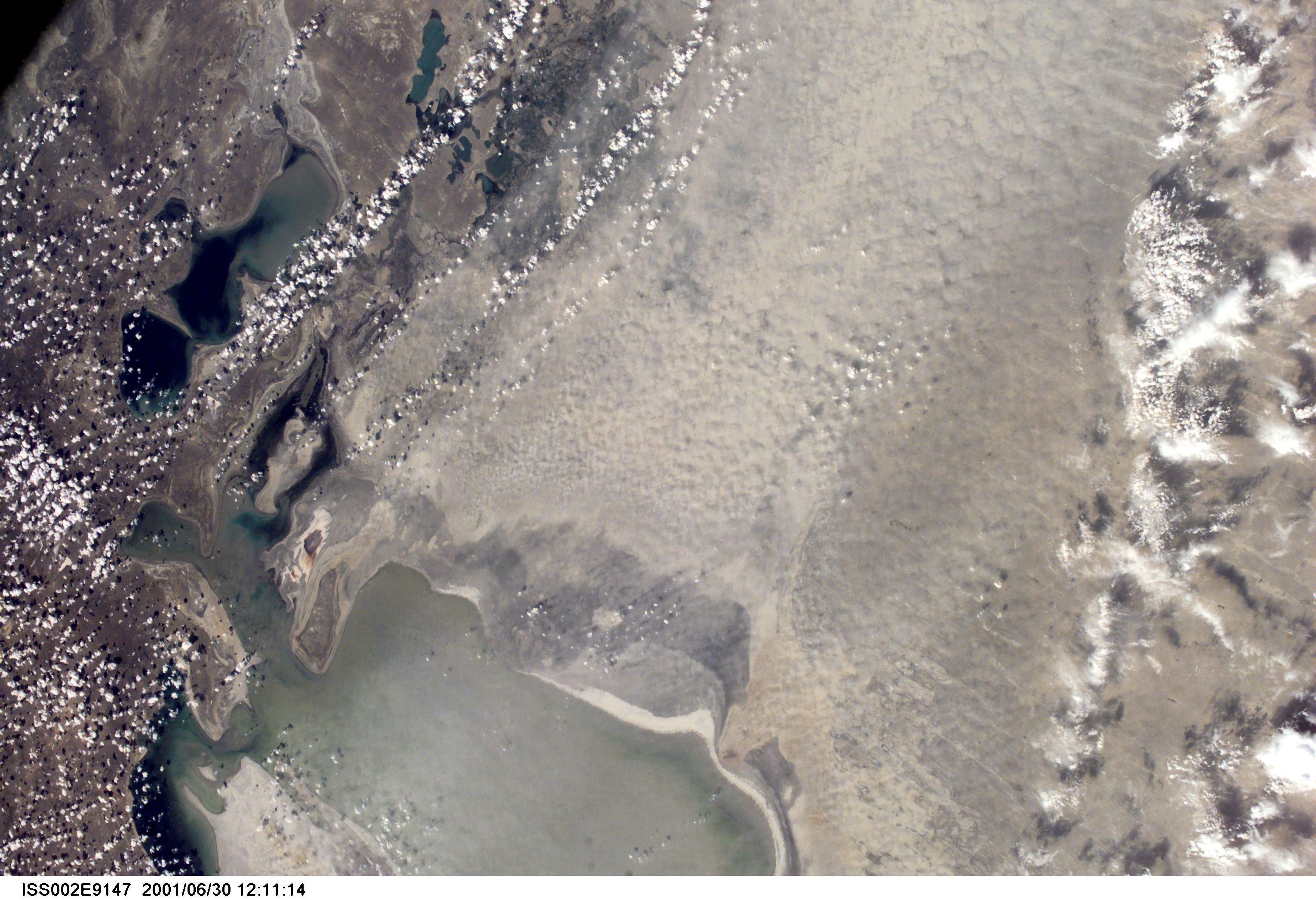
Features: ARAL SEA, DUST STORM
Center Point Latitude: 45.0 Center Point Longitude: 60.5 (Negative numbers indicate south for latitude and west for longitude)
Stereo: (Yes indicates there is an adjacent picture of the same area)
ONC Map ID: JNC Map ID:
Camera
Camera Tilt: High ObliqueCamera Focal Length: 35mm
Camera: E2: Kodak DCS460 Electronic Still Camera
Film: 3060E : 3060 x 2036 pixel CCD, RGBG array.
Quality
Film Exposure:Percentage of Cloud Cover: 10 (0-10)
Nadir
Date: 20010630 (YYYYMMDD)GMT Time: 113214 (HHMMSS)Nadir Point Latitude: 32.0, Longitude: 80.3 (Negative numbers indicate south for latitude and west for longitude)
Nadir to Photo Center Direction: Northwest
Sun Azimuth: 282 (Clockwise angle in degrees from north to the sun measured at the nadir point)
Spacecraft Altitude: 202 nautical miles (374 km)
Sun Elevation Angle: 26 (Angle in degrees between the horizon and the sun, measured at the nadir point)
Orbit Number: 2917
Captions
The Aral Sea has shrunk to less than half its size since 1985. The Aral Sea receives little water sometimes no water) from the two major rivers that empty into it-the Syr Darya and Amu Darya. Instead, the river water is diverted to support irrigation for the region’s extensive cotton fields. Recently, water scarcity has increased due to a prolonged drought in Central Asia. As the Aral Sea recedes, its former sea bed is exposed. The Aral’s sea bed is composed of fine sediments-including fertilizers and other agricultural chemicals-that are easily picked up by the region’s strong winds, creating thick dust storms. The International Space Station crew observed and recorded a large dust storm blowing eastward from the Aral Sea in late June 2001. This image illustrates the strong coupling between human activities (water diversions and irrigation), and rapidly changing land, sea and atmospheric processes-the winds blow across the Sea and pick up dust (former sea bottom sediments) as soon as the blowing air masses hit land. Note that the northern boundary of the dust storm occurs along the Syr Darya, where no bottom sediments are exposed.Download Packaged File.
This option downloads the following items, packaged into a single file, if they are available:
- Browse image
- Cataloged information with captions
- Camera file
- Sound file
Server: 2 |
This service is provided by the International Space Station program. |
Recommended Citation: |
||

