| Home >> | Advanced Search >> |
 |
|
Astronaut Photography of Earth - Display Record
ISS002-707-87

Low-resolution Browse Image
(Most browse images are not color adjusted.)Images
Conditions for Use of Images >>Image Transformation Tutorial >> Saving, Color Adjusting, and Printing Images >>
Images to View on Your Computer Now
| File Name | File Size (bytes) | Width | Height | Annotated | Cropped | Purpose | Comments | |
|---|---|---|---|---|---|---|---|---|
| View | ISS002-707-87.JPG | 42261 | 515 | 512 | No | No | From ISD PhotoCDs | |
| View | ISS002-707-87.JPG | 74538 | 540 | 524 | Yes | NASA's Earth Observatory web site | ||
| View | ISS002-707-87.JPG | 257828 | 1000 | 980 | No | Yes | NASA's Earth Observatory web site | Color adjusted, georeferenced |
Large Images to Request for Downloading
| File Name | File Size (bytes) | Width | Height | Annotated | Cropped | Purpose | Comments | |
|---|---|---|---|---|---|---|---|---|
| Request | ISS002-707-87.JPG | 138683 | 1031 | 1024 | No | No | From ISD PhotoCDs | |
| Request | ISS002-707-87.JPG | 257828 | 1000 | 980 | Yes | NASA's Earth Observatory web site | ||
| Request | ISS002-707-87_2.JPG | 421897 | 2063 | 2048 | No | No | From ISD PhotoCDs | |
| Request | ISS002-707-87_3.JPG | 1120829 | 4127 | 4096 | No | No | From ISD PhotoCDs |
Download a Keyhole Markup Language (KML) file for use in Google Earth.
Electronic Image Data
Camera files only apply to electronic still cameras.No sound file available.
Identification
Mission: ISS002 Roll: 707 Frame: 87 Mission ID on the Film or image: ISS002Country or Geographic Name: USA-UTAH
Features: GREAT SALT LAKE AREA
Center Point Latitude: 41.5 Center Point Longitude: -112.5 (Negative numbers indicate south for latitude and west for longitude)
Stereo: (Yes indicates there is an adjacent picture of the same area)
ONC Map ID: JNC Map ID:
Camera
Camera Tilt:Camera Focal Length: 110mm
Camera: HB: Hasselblad
Film: 5069 : Kodak Elite 100S, E6 Reversal, Replaces Lumiere, Warmer in tone vs. Lumiere.
Quality
Film Exposure:Percentage of Cloud Cover: 25 (11-25)
Nadir
Date: 2001____ (YYYYMMDD)GMT Time: (HHMMSS)Nadir Point Latitude: , Longitude: (Negative numbers indicate south for latitude and west for longitude)
Nadir to Photo Center Direction:
Sun Azimuth: (Clockwise angle in degrees from north to the sun measured at the nadir point)
Spacecraft Altitude: nautical miles (0 km)
Sun Elevation Angle: (Angle in degrees between the horizon and the sun, measured at the nadir point)
Orbit Number:
Captions
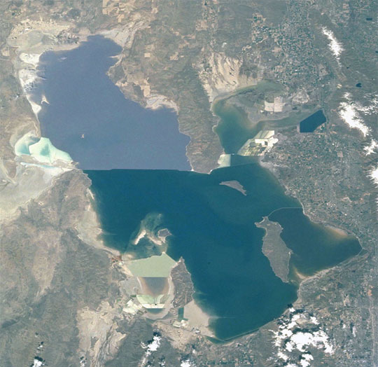
Effect of Drought on Great Salt Lake:Great Salt Lake serves as a striking visual marker for astronauts orbiting over North America. A sharp line across its center is caused by the restriction in water flow from the railroad causeway. The eye-catching colors of the lake stem from the fact that Great Salt Lake is hypersaline, typically 3-5 times saltier than the ocean, and the high salinities support sets of plants and animals that affect the light-absorbing qualities of the water. North of the causeway salinities are higher, and the water turns red from the pigments of halophilic bacteria. In the shallower corners of the lake, earthen dikes mark large salt evaporation works, which take on the jewel tones of turquoise, russet, amber, and pearl white.
The detailed image (ISS005-E-16729) shows some of the salt works operated by Great Salt Lake Minerals and Chemicals Corporation near West Warren, Utah, on the eastern shore of the lake. Evaporative salt harvesting at Great Salt Lake is an important source of minerals for industrial uses. The lake contains an estimated 5 billion tons of salt, with 2.5 million additional tons washing in each year. Extraction rates are slightly higher than the amount added to the lake each year. In addition to sodium chloride, the ponds near West Warren are used to extract potassium sulfate and magnesium chloride, which are used to make fertilizers.
Space Station astronauts have recorded the decline in lake levels in response to a regional 5-year drought taking both detailed views and broad views of the entire lake (ISS007-E-13002 and this image). As lake levels have declined the salt works have become islands in the middle of a dry lakebed. Seasonal fluctuations in Great Salt Lake produce annual lows every fall, but there are significant longer-term fluctuations in lake levels relating to the climate. Great Salt Lake hit a 22-year low at 4,198 feet in the fall of 2002, and a near-record low again in October 2003. The lowest level ever recorded was 4,191 feet in 1963, and the highest levels were 4,212 feet in June 1986 and April 1987. Experimental scientific forecasts predict that lake levels will begin gradually increasing again, but the U.S. Seasonal Drought Outlook indicates only limited improvement from this snow season because the water deficits are so high.
Around the world, lake levels are an excellent indicator of local climate. Repeat observations over time allow comparisons and levels rise and fall in response to droughts and the broader climate patterns that are linked to droughts.
Less-detailed images of the decline in the Great Salt Lake as seen from Terra satellite’s Moderate Resolution Imaging Spectroradiometer (MODIS) sensor were previously shown on Earth Observatory. MODIS has also documented dust storms related to the drought.
Space Station images of Salt Lake City were also previously featured on Earth Observatory.
Download Packaged File.
This option downloads the following items, packaged into a single file, if they are available:
- Browse image
- Cataloged information with captions
- Camera file
- Sound file
Server: 2 |
This service is provided by the International Space Station program. |
Recommended Citation: |
||

