| Home >> | Advanced Search >> |
 |
|
Astronaut Photography of Earth - Display Record
ISS010-E-8524
Low-resolution Browse Image
(Most browse images are not color adjusted.)Images
Conditions for Use of Images >>Image Transformation Tutorial >> Saving, Color Adjusting, and Printing Images >>
Images to View on Your Computer Now
| File Name | File Size (bytes) | Width | Height | Annotated | Cropped | Purpose | Comments | |
|---|---|---|---|---|---|---|---|---|
| View | ISS010-E-8524.JPG | 78612 | 639 | 435 | No | No | ||
| View | ISS010-E-8524.JPG | 382647 | 540 | 480 | Yes | Yes | NASA's Earth Observatory web site | |
| View | ISS010-E-8524.JPG | 382647 | 540 | 480 | Yes | Yes | Earth From Space collection | |
| View | ISS010-E-8524.JPG | 1259471 | 1000 | 889 | No | Yes | NASA's Earth Observatory web site |
Large Images to Request for Downloading
| File Name | File Size (bytes) | Width | Height | Annotated | Cropped | Purpose | Comments | |
|---|---|---|---|---|---|---|---|---|
| Request | ISS010-E-8524.JPG | 1090188 | 3032 | 2064 | No | No | ||
| Request | ISS010-E-8524.JPG | 1259471 | 1000 | 889 | No | Yes | Earth From Space collection |
Download a Keyhole Markup Language (KML) file for use in Google Earth.
Electronic Image Data
Camera Files >> No sound file available.Identification
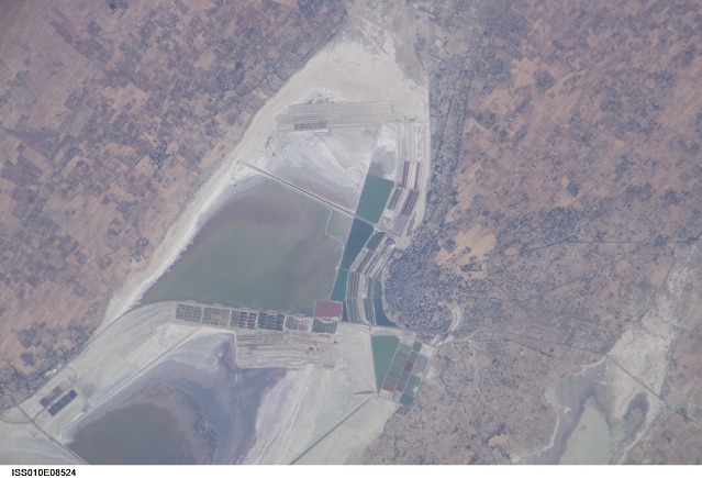
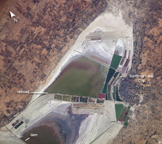
Mission: ISS010 Roll: E Frame: 8524 Mission ID on the Film or image: ISS010Country or Geographic Name: INDIA
Features: SAMBHAR, SALTWORKS, AGR.
Center Point Latitude: 26.9 Center Point Longitude: 75.2 (Negative numbers indicate south for latitude and west for longitude)
Stereo: (Yes indicates there is an adjacent picture of the same area)
ONC Map ID: JNC Map ID:
Camera
Camera Tilt: 31Camera Focal Length: 800mm
Camera: E4: Kodak DCS760C Electronic Still Camera
Film: 3060E : 3060 x 2036 pixel CCD, RGBG array.
Quality
Film Exposure:Percentage of Cloud Cover: 10 (0-10)
Nadir
Date: 20041124 (YYYYMMDD)GMT Time: 073355 (HHMMSS)Nadir Point Latitude: 28.3, Longitude: 76.5 (Negative numbers indicate south for latitude and west for longitude)
Nadir to Photo Center Direction: Southwest
Sun Azimuth: 196 (Clockwise angle in degrees from north to the sun measured at the nadir point)
Spacecraft Altitude: 189 nautical miles (350 km)
Sun Elevation Angle: 40 (Angle in degrees between the horizon and the sun, measured at the nadir point)
Orbit Number: 2347
Captions
Lake Sambhar, IndiaLake Sambhar, India’s largest salt lake, sits west of the Indian city of Jaipur (Rajasthan, NW India). On the eastern end, the lake is divided by a 5-km long dam made of stone. East of the dam are salt evaporation ponds where salt has been farmed for a thousand years.
This image, taken by astronauts aboard the International Space Station, shows Lake Sambhar’s eastern saltworks in detail. Today, they are operated by a joint venture between Hindustan Salts and the Government of Rajasthan. East of the dam is a railroad, built by the British (before India’s independence) that provides access from Sambhar Lake City to the salt works.
More importantly, Sambhar has been designated as a Ramsar site (recognized wetland of international importance) because the wetland is a key wintering area for tens of thousands of flamingos and other birds that migrate from northern Asia. The lake is actually an extensive saline wetland, with water depths fluctuating from just a few centimeters (1 inch) during the dry season to about 3 meters (10 feet) after monsoon season. The specialized algae and bacteria growing in the lake provide striking water colors and support the lake ecology that, in turn, sustains the migrating waterfowl.
Download Packaged File.
This option downloads the following items, packaged into a single file, if they are available:
- Browse image
- Cataloged information with captions
- Camera file
- Sound file
Server: 2 |
This service is provided by the International Space Station program. |
Recommended Citation: |
||

