| Home >> | Advanced Search >> |
 |
|
Astronaut Photography of Earth - Display Record
ISS017-E-8290

Low-resolution Browse Image
(Most browse images are not color adjusted.)Images
Conditions for Use of Images >>Image Transformation Tutorial >> Saving, Color Adjusting, and Printing Images >>
Images to View on Your Computer Now
| File Name | File Size (bytes) | Width | Height | Annotated | Cropped | Purpose | Comments | |
|---|---|---|---|---|---|---|---|---|
| View | ISS017-E-8290.JPG | 75430 | 437 | 639 | No | No | ||
| View | ISS017-E-8290.JPG | 273221 | 540 | 357 | Yes | Yes | NASA's Earth Observatory web site |
Large Images to Request for Downloading
| File Name | File Size (bytes) | Width | Height | Annotated | Cropped | Purpose | Comments | |
|---|---|---|---|---|---|---|---|---|
| Request | ISS017-E-8290.JPG | 826736 | 1000 | 661 | No | Yes | NASA's Earth Observatory web site | |
| Request | ISS017-E-8290.JPG | 1469087 | 2098 | 3072 | No | No |
Download a Keyhole Markup Language (KML) file for use in Google Earth.
Electronic Image Data
Camera Files >> No sound file available.Identification
Mission: ISS017 Roll: E Frame: 8290 Mission ID on the Film or image: ISS017Country or Geographic Name: EGYPT
Features: TOSHKA LAKES, SAND DUNES
Center Point Latitude: 23.3 Center Point Longitude: 30.6 (Negative numbers indicate south for latitude and west for longitude)
Stereo: (Yes indicates there is an adjacent picture of the same area)
ONC Map ID: JNC Map ID:
Camera
Camera Tilt: 32Camera Focal Length: 800mm
Camera: N2: Nikon D2Xs
Film: 4288E : 4288 x 2848 pixel CMOS sensor, RGBG imager color filter.
Quality
Film Exposure:Percentage of Cloud Cover: 10 (0-10)
Nadir
Date: 20080531 (YYYYMMDD)GMT Time: 131737 (HHMMSS)Nadir Point Latitude: 21.6, Longitude: 31.5 (Negative numbers indicate south for latitude and west for longitude)
Nadir to Photo Center Direction: Northwest
Sun Azimuth: 281 (Clockwise angle in degrees from north to the sun measured at the nadir point)
Spacecraft Altitude: 183 nautical miles (339 km)
Sun Elevation Angle: 42 (Angle in degrees between the horizon and the sun, measured at the nadir point)
Orbit Number: 2590
Captions
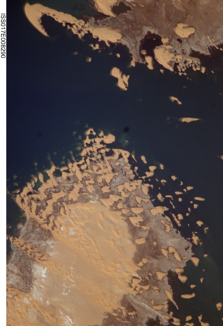
Toshka Lakes, Southern EgyptIn the late 1990s, Egypt’s new manmade Toshka Lakes, fed from Lake Nasser via a canal, grew and spilled into new basins to become four major and two smaller lakes. These lakes extended 120 kilometers across the desert west of the Nile River in southern Egypt. Starting in 2002, astronauts have seen the lakes slowly decline, with the telltale ring of darker, moistened ground showing the previous higher water levels (see prior comparison of astronaut imagery of the lakes). The rise and fall of Toshka Lakes and the economic development surrounding the region are dependent on climate fluctuations and water agreements with upstream countries that, in turn, determine the long-term water flow in the lower Nile.
This astronaut photograph, covering a distance of 11.3 kilometers from left to right, shows shoreline detail of the third large lake. Lake water appears deep blue to blue-green, and parallel with the shoreline is a wide brown zone which was under water until 2002. Most of the bright yellow sand dunes in the view are re-emerging as the lake level drops; most are outlined by thin wet margins. Still-submerged dunes can be seen offshore as blurred tan smudges (image top center). The summit of the biggest horn-shaped dune (image top right) was an island more than five kilometers offshore in images from 2001. The patterns of the overlapping crescent dunes gives a strong sense of dune migration southwards; the horns of the crescent dunes point in the direction of dune movement, from top right towards lower left. Dominant northerly winds drive the dunes southward, except, of course, when they are under water.
Download Packaged File.
This option downloads the following items, packaged into a single file, if they are available:
- Browse image
- Cataloged information with captions
- Camera file
- Sound file
Server: 2 |
This service is provided by the International Space Station program. |
Recommended Citation: |
||

