| Home >> | Advanced Search >> |
 |
|
Astronaut Photography of Earth - Display Record
ISS015-E-7934
Low-resolution Browse Image
(Most browse images are not color adjusted.)Images
Conditions for Use of Images >>Image Transformation Tutorial >> Saving, Color Adjusting, and Printing Images >>
Images to View on Your Computer Now
| File Name | File Size (bytes) | Width | Height | Annotated | Cropped | Purpose | Comments | |
|---|---|---|---|---|---|---|---|---|
| View | ISS015-E-7934.JPG | 102607 | 639 | 435 | No | No | ||
| View | ISS015-E-7934.JPG | 493579 | 540 | 586 | Yes | Yes | NASA's Earth Observatory web site |
Large Images to Request for Downloading
| File Name | File Size (bytes) | Width | Height | Annotated | Cropped | Purpose | Comments | |
|---|---|---|---|---|---|---|---|---|
| Request | ISS015-E-7934.JPG | 1437771 | 1000 | 1086 | No | Yes | NASA's Earth Observatory web site | |
| Request | ISS015-E-7934.JPG | 1713544 | 3032 | 2064 | No | No |
Download a Keyhole Markup Language (KML) file for use in Google Earth.
Electronic Image Data
Camera Files >> No sound file available.Identification
Mission: ISS015 Roll: E Frame: 7934 Mission ID on the Film or image: ISS015Country or Geographic Name: MEXICO
Features: GULF OF CALIFORNIA,MAZATLAN
Center Point Latitude: 23.2 Center Point Longitude: -106.3 (Negative numbers indicate south for latitude and west for longitude)
Stereo: (Yes indicates there is an adjacent picture of the same area)
ONC Map ID: JNC Map ID:
Camera
Camera Tilt: 8Camera Focal Length: 400mm
Camera: E4: Kodak DCS760C Electronic Still Camera
Film: 3060E : 3060 x 2036 pixel CCD, RGBG array.
Quality
Film Exposure:Percentage of Cloud Cover: 10 (0-10)
Nadir
Date: 20070513 (YYYYMMDD)GMT Time: 210431 (HHMMSS)Nadir Point Latitude: 23.2, Longitude: -105.9 (Negative numbers indicate south for latitude and west for longitude)
Nadir to Photo Center Direction: West
Sun Azimuth: 267 (Clockwise angle in degrees from north to the sun measured at the nadir point)
Spacecraft Altitude: 177 nautical miles (328 km)
Sun Elevation Angle: 61 (Angle in degrees between the horizon and the sun, measured at the nadir point)
Orbit Number: 535
Captions
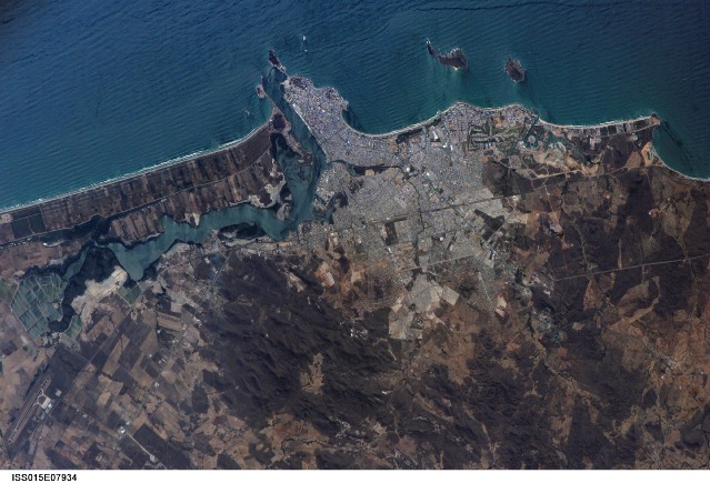
ISS015-E-07934 (13 May 2007) --- Mazatlan, Mexico is featured in this image photographed by an Expedition 15 crewmember on the International Space Station. Mazatlan is Mexico's largest port, situated on one of the best estuaries on Mexico's Pacific coast, illustrated well in this image. Docks and naval yards line the north side of the estuary. The city itself appears as a series of light-toned city blocks covering the center of the image. Mazatlan (population of 352,000 in 2005) is growing northward from the downtown peninsula, with tourist beaches backed by hotels, and a marina and golf courses just beyond. No city growth yet appears on the south side the estuary where farm lands can be seen. The famous Faro Lighthouse occupies the top of a steep island--now connected by a bridge to the mainland--at the mouth of the estuary (top center). The Faro Lighthouse is the second tallest in the world behind Gibraltar's. The wide, straight, almost vertical line of the railroad appears to bisect the picture. This image shows sea features well, primarily ocean swells coming in from the southwest, which appear as a series of parallel lines covering the entire sea surface in this view. An oil slick offshore of the tourist beaches appears as a dark line along the left side of the image.Mazatlan, Mexico:
Mazatlán is Mexico’s largest port, situated on one of the best estuaries (bottom center of image) on Mexico’s Pacific coast. The city appears as a series of light-toned geometric blocks covering the center of this astronaut photograph. The image also shows the docks and naval yards that line the north side of the estuary. Mazatlán (population 352,000 in 2005) is growing northward from the downtown peninsula, with tourist beaches backed by hotels, and a marina and golf courses just beyond. No city growth yet appears on the south side of the estuary, where narrow rectangles of farm land can be seen.
The famous Faro Lighthouse occupies the top of a steep island—now connected by a bridge to the mainland—at the mouth of the estuary (image lower left). The Faro Lighthouse is the second tallest in the world, after Gibraltar’s. The wide, straight, almost vertical line of the railroad bisects the city.
This image shows sea features well, primarily ocean swells coming in from the southwest, which appear as a series of parallel lines covering the entire sea surface in this image. The diverse activities that go on in busy urban areas do not always mix easily: an oil slick offshore of the tourist beaches appears as a dark line along the left side of the image.
Download Packaged File.
This option downloads the following items, packaged into a single file, if they are available:
- Browse image
- Cataloged information with captions
- Camera file
- Sound file
Server: 2 |
This service is provided by the International Space Station program. |
Recommended Citation: |
||

