| Home >> | Advanced Search >> |
 |
|
Astronaut Photography of Earth - Display Record
ISS015-E-7928

Low-resolution Browse Image
(Most browse images are not color adjusted.)Images
Conditions for Use of Images >>Image Transformation Tutorial >> Saving, Color Adjusting, and Printing Images >>
Images to View on Your Computer Now
| File Name | File Size (bytes) | Width | Height | Annotated | Cropped | Purpose | Comments | |
|---|---|---|---|---|---|---|---|---|
| View | ISS015-E-7928.JPG | 62617 | 639 | 435 | No | No | ||
| View | ISS015-E-7928.JPG | 236869 | 540 | 367 | Yes | Yes | NASA's Earth Observatory web site |
Large Images to Request for Downloading
| File Name | File Size (bytes) | Width | Height | Annotated | Cropped | Purpose | Comments | |
|---|---|---|---|---|---|---|---|---|
| Request | ISS015-E-7928.JPG | 739405 | 1000 | 680 | No | Yes | NASA's Earth Observatory web site | |
| Request | ISS015-E-7928.JPG | 1193492 | 3032 | 2064 | No | No |
Download a Keyhole Markup Language (KML) file for use in Google Earth.
Electronic Image Data
Camera Files >> No sound file available.Identification
Mission: ISS015 Roll: E Frame: 7928 Mission ID on the Film or image: ISS015Country or Geographic Name: MEXICO
Features: SAN LORENZO I.,WAVE PATTERNS
Center Point Latitude: 28.6 Center Point Longitude: -112.8 (Negative numbers indicate south for latitude and west for longitude)
Stereo: (Yes indicates there is an adjacent picture of the same area)
ONC Map ID: JNC Map ID:
Camera
Camera Tilt: 25Camera Focal Length: 400mm
Camera: E4: Kodak DCS760C Electronic Still Camera
Film: 3060E : 3060 x 2036 pixel CCD, RGBG array.
Quality
Film Exposure:Percentage of Cloud Cover: 10 (0-10)
Nadir
Date: 20070513 (YYYYMMDD)GMT Time: 210231 (HHMMSS)Nadir Point Latitude: 29.0, Longitude: -111.5 (Negative numbers indicate south for latitude and west for longitude)
Nadir to Photo Center Direction: West
Sun Azimuth: 251 (Clockwise angle in degrees from north to the sun measured at the nadir point)
Spacecraft Altitude: 177 nautical miles (328 km)
Sun Elevation Angle: 65 (Angle in degrees between the horizon and the sun, measured at the nadir point)
Orbit Number: 535
Captions
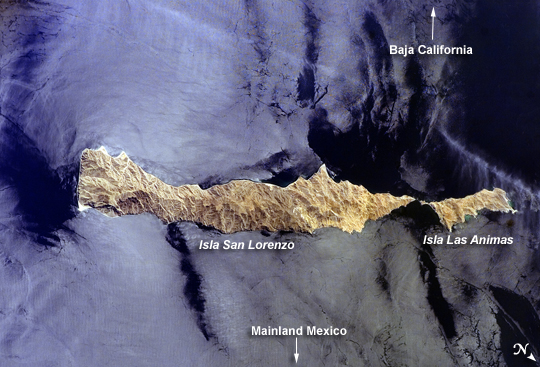
ISS015-E-07928 (13 May 2007) --- Isla San Lorenzo and Isla Las Animas are featured in this image photographed by an Expedition 15 crewmember on the International Space Station. Located in the northern Gulf of California, Isla (island) San Lorenzo and Isla Las Animas -- part of the Midriff Islands -- record geologic processes involved in the creation of the Baja California peninsula over several hundred million years, according to scientists. A geologist walking along the 17-kilometer long central ridge of Isla San Lorenzo from the southeastern to the northwestern end would first encounter Cretaceous granitic rock in the southeastern third of the island (light tan, center left). The central third of the island is comprised mainly of older Paleozoic metamorphic rocks (brown, center; directly above "Isla San Lorenzo"). Together, these very old rocks form the crystalline "basement" of the island. The northwestern third of Isla San Lorenzo, and much of adjacent Isla Las Animas, is composed of much more recent volcanic and marine sedimentary rocks (yellow-brown to light brown, center right). According to scientists, these rocks were formed by volcanoes and fissure eruptions in and around basins in the growing Gulf of California between 5-8 million years ago. The islands themselves were formed as a result of uplift of crustal blocks along the southeastward-trending San Andreas Fault. This image illustrates the largely pristine nature of these islands. The islands are located in the rain shadow of mountains on the Baja Peninsula to the west, and arid conditions prevail through much of the year. The scarcity of water has limited human presence on the islands, and allowed flora and fauna unique to each island (known as endemic species) to flourish -- particularly reptiles. The islands are also home to colonies of seabirds and seals, both of which take advantage of deep productive waters adjacent to the eastern Baja coast. Shallow waters and high levels of nutrients can also lead to blooms of green phytoplankton; two such blooms can be seen along the coastline of Isla Las Animas (center right, in north and west-facing embayments). Surface water patterns around the islands -- enhanced by sunlight reflectance off the water surface -- are due to wind- and current-induced roughness (silver-gray regions). Regions of dark blue water are indicative of calm surface conditions, or the presence of oils and surfactants that decrease surface tension.Isla San Lorenzo and Isla Las Animas, Gulf of California:
Located in the northern Gulf of California, Isla (island) San Lorenzo and Isla Las Animas—part of the Midriff Islands—record geologic processes involved in the creation of the Baja California peninsula over several hundred million years. If you were hiking southeast to northwest along the 17-kilometer-long (10.6-mile) central ridge of Isla San Lorenzo, you would first encounter granite rocks from the Cretaceous Period (146 to 65 million years ago); this light tan rock occupies the southeastern third of the island (image center left). In the central third of the island, you would see mainly older metamorphic rocks from the Paleozoic Era (543 to 248 million years ago); these rocks are brown (image center). At the end of the hike, at the northwestern third of Isla San Lorenzo (and much of adjacent Isla Las Animas), you would find much younger volcanic and marine sedimentary rocks (yellow-brown to light brown, image center right). These rocks were formed by volcanoes and fissure eruptions in and around basins in the growing Gulf of California between 5–8 million years ago. The islands themselves were formed as a result of uplift of crustal blocks along the southeastward-trending San Andreas Fault.
This astronaut photograph illustrates the largely pristine nature of these islands. The islands are located in the rain shadow of mountains on the Baja Peninsula to the west, and arid conditions prevail through much of the year. The scarcity of water has limited human presence on the islands, and allowed flora and fauna unique to each island to flourish, particularly reptiles. The islands are also home to colonies of seabirds and seals, both of which take advantage of deep, productive waters adjacent to the eastern Baja coast. Shallow waters and high levels of nutrients can also lead to blooms of green phytoplankton; two such blooms can be seen along the coastline of Isla Las Animas (image center right, in north- and west-facing bays). Winds and currents roughen the surface waters around the islands, and sunlight reflecting off the water makes the patterns visible (silver-gray regions). Regions of dark blue water indicate calm surface conditions, or the presence of oils and surfactants that decrease surface tension.
Download Packaged File.
This option downloads the following items, packaged into a single file, if they are available:
- Browse image
- Cataloged information with captions
- Camera file
- Sound file
Server: 2 |
This service is provided by the International Space Station program. |
Recommended Citation: |
||

