| Home >> | Advanced Search >> |
 |
|
Astronaut Photography of Earth - Display Record
ISS007-E-7878
Low-resolution Browse Image
(Most browse images are not color adjusted.)Images
Conditions for Use of Images >>Image Transformation Tutorial >> Saving, Color Adjusting, and Printing Images >>
Images to View on Your Computer Now
| File Name | File Size (bytes) | Width | Height | Annotated | Cropped | Purpose | Comments | |
|---|---|---|---|---|---|---|---|---|
| View | ISS007-E-7878.JPG | 19920 | 540 | 352 | Photographic Highlights | (resized 540 px images) | ||
| View | ISS007-E-7878.JPG | 28303 | 639 | 435 | No | No | ||
| View | ISS007-E-7878.JPG | 37952 | 540 | 405 | Yes | Yes | NASA's Earth Observatory web site |
Large Images to Request for Downloading
| File Name | File Size (bytes) | Width | Height | Annotated | Cropped | Purpose | Comments | |
|---|---|---|---|---|---|---|---|---|
| Request | ISS007-E-7878.JPG | 72861 | 1024 | 668 | Photographic Highlights | (actual files used) | ||
| Request | ISS007-E-7878.JPG | 497417 | 3032 | 2064 | No | No | ||
| Request | ISS007-E-7878_2.JPG | 2756889 | 6144 | 4068 | No | No | Presentation | Earth Sciences Results Briefing/Ed Lu |
Download a Keyhole Markup Language (KML) file for use in Google Earth.
Electronic Image Data
Camera Files >> No sound file available.Identification
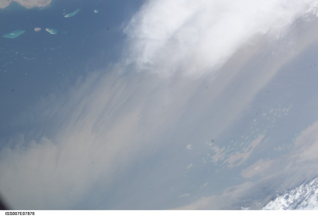
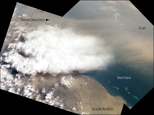
Mission: ISS007 Roll: E Frame: 7878 Mission ID on the Film or image: ISS007Country or Geographic Name: SAUDI ARABIA
Features: THUNDERSTORM, DUST, RED SEA
Center Point Latitude: 17.5 Center Point Longitude: 40.5 (Negative numbers indicate south for latitude and west for longitude)
Stereo: (Yes indicates there is an adjacent picture of the same area)
ONC Map ID: JNC Map ID:
Camera
Camera Tilt: 47Camera Focal Length: 50mm
Camera: E4: Kodak DCS760C Electronic Still Camera
Film: 3060E : 3060 x 2036 pixel CCD, RGBG array.
Quality
Film Exposure:Percentage of Cloud Cover: 50 (26-50)
Nadir
Date: 20030622 (YYYYMMDD)GMT Time: 133245 (HHMMSS)Nadir Point Latitude: 19.2, Longitude: 43.8 (Negative numbers indicate south for latitude and west for longitude)
Nadir to Photo Center Direction: Southwest
Sun Azimuth: 287 (Clockwise angle in degrees from north to the sun measured at the nadir point)
Spacecraft Altitude: 210 nautical miles (389 km)
Sun Elevation Angle: 28 (Angle in degrees between the horizon and the sun, measured at the nadir point)
Orbit Number: 2184
Captions
Which came first, the clouds or the dust? Both clouds and dust can be important factors influencing regional climate, and they are frequently observed together.In this view taken from the International Space Station, two images were merged to create a mosaic of a dust storm and thunderstorm over the Red Sea. By interpreting the mosaic, we make a guess about which came first.
Saudi Arabia’s southernmost coast facing the Red Sea appears in the foreground, and the African side of the Red Sea in Eritrea appears at the top of this view, slightly obscured under a light screen of dust. Wind directions on the day this view was taken (June 22, 2003) are difficult to interpret. Southeasterly flow from the Arabian Sea, related to monsoonal wind fields, seems to be dominant, and probably explains the more distant dust at the top of the view. As the southeasterly winds ascend over the hills that flank that Red Sea (center left), a local thunderstorm has developed. Downdrafts from the dying storm probably generated at least some of the dust seen out over the Red Sea.
It is common to see dust related to thunderstorms in this way. At a broader scale, however, the opposite is more often true: regional dust in the atmosphere tends to reduce cloud development and thus rainfall. The southern Arabian Peninsula is a center of dust generation in global terms and dust clouds are often imaged over the Red Sea by astronauts. Dust is transported in both directions across the Sea, from Arabian and from Saharan sources. Astronaut observations of dust and clouds provide useful information about their interactions.
Download Packaged File.
This option downloads the following items, packaged into a single file, if they are available:
- Browse image
- Cataloged information with captions
- Camera file
- Sound file
Server: 2 |
This service is provided by the International Space Station program. |
Recommended Citation: |
||

