| Home >> | Advanced Search >> |
 |
|
Astronaut Photography of Earth - Display Record
ISS008-E-7600

Low-resolution Browse Image
(Most browse images are not color adjusted.)Images
Conditions for Use of Images >>Image Transformation Tutorial >> Saving, Color Adjusting, and Printing Images >>
Images to View on Your Computer Now
| File Name | File Size (bytes) | Width | Height | Annotated | Cropped | Purpose | Comments | |
|---|---|---|---|---|---|---|---|---|
| View | ISS008-E-7600.JPG | 110731 | 639 | 435 | No | No | ||
| View | ISS008-E-7600.JPG | 154563 | 540 | 357 | Yes | Yes | Earth From Space collection | |
| View | ISS008-E-7600.JPG | 831745 | 1000 | 662 | No | Yes | NASA's Earth Observatory web site |
Large Images to Request for Downloading
| File Name | File Size (bytes) | Width | Height | Annotated | Cropped | Purpose | Comments | |
|---|---|---|---|---|---|---|---|---|
| Request | ISS008-E-7600.JPG | 1238579 | 3032 | 2064 | No | No |
Download a Keyhole Markup Language (KML) file for use in Google Earth.
Electronic Image Data
Camera Files >> No sound file available.Identification
Mission: ISS008 Roll: E Frame: 7600 Mission ID on the Film or image: ISS008Country or Geographic Name: RUSSIAN FEDERATION
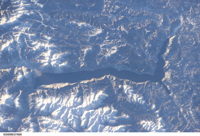
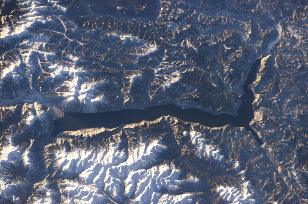
Features: LAKE TELETSKOYE
Center Point Latitude: 51.5 Center Point Longitude: 87.5 (Negative numbers indicate south for latitude and west for longitude)
Stereo: (Yes indicates there is an adjacent picture of the same area)
ONC Map ID: JNC Map ID:
Camera
Camera Tilt: 26Camera Focal Length: 155mm
Camera: E4: Kodak DCS760C Electronic Still Camera
Film: 3060E : 3060 x 2036 pixel CCD, RGBG array.
Quality
Film Exposure:Percentage of Cloud Cover: 10 (0-10)
Nadir
Date: 20031210 (YYYYMMDD)GMT Time: 082401 (HHMMSS)Nadir Point Latitude: 51.3, Longitude: 85.9 (Negative numbers indicate south for latitude and west for longitude)
Nadir to Photo Center Direction: East
Sun Azimuth: 211 (Clockwise angle in degrees from north to the sun measured at the nadir point)
Spacecraft Altitude: 199 nautical miles (369 km)
Sun Elevation Angle: 10 (Angle in degrees between the horizon and the sun, measured at the nadir point)
Orbit Number: 854
Captions
Lake Teletskoye, RussiaLake Teletskoye, one of Siberia’s prime tourist destinations, is a large lake that is nestled in a narrow valley between the snow-capped Al-tyntu (west, at top) and Korbu (east, at bottom) mountain ridges of the Altai Mountains. The lake is nearly 80 kilometers long by 5 kilometers wide and 325 meters deep; it is one of the deepest lakes in the world.
But Lake Teletskoye is more than a large, deep lake. It is located within the 9,000 km2 Altaisky Zapovednik nature reserve, which helps protect its unspoiled waters. The main flow into the lake is the Tchulyshman River, but approximately 70 rivers and hundreds of seasonal streams also flow into the lake. The lake water drains and ultimately flows north to become one of Siberia’s great rivers, the Ob. Surrounding the lake are ancient taiga forests. Large lakes such as Teletskoye serve as repositories of regional paleoclimate data including sediment records and atmospheric pollutants. Teletskoye is included as one of Russia’s long-term ecological monitoring sites.
Download Packaged File.
This option downloads the following items, packaged into a single file, if they are available:
- Browse image
- Cataloged information with captions
- Camera file
- Sound file
Server: 2 |
This service is provided by the International Space Station program. |
Recommended Citation: |
||

