| Home >> | Advanced Search >> |
 |
|
Astronaut Photography of Earth - Display Record
ISS015-E-7543
Low-resolution Browse Image
(Most browse images are not color adjusted.)Images
Conditions for Use of Images >>Image Transformation Tutorial >> Saving, Color Adjusting, and Printing Images >>
Images to View on Your Computer Now
| File Name | File Size (bytes) | Width | Height | Annotated | Cropped | Purpose | Comments | |
|---|---|---|---|---|---|---|---|---|
| View | ISS015-E-7543.JPG | 39562 | 639 | 435 | No | No | ||
| View | ISS015-E-7543.JPG | 78766 | 540 | 405 | Yes | Yes | NASA's Earth Observatory web site |
Large Images to Request for Downloading
| File Name | File Size (bytes) | Width | Height | Annotated | Cropped | Purpose | Comments | |
|---|---|---|---|---|---|---|---|---|
| Request | ISS015-E-7543.JPG | 265471 | 1000 | 750 | No | Yes | NASA's Earth Observatory web site | |
| Request | ISS015-E-7543.JPG | 746110 | 3032 | 2064 | No | No |
Download a Keyhole Markup Language (KML) file for use in Google Earth.
Electronic Image Data
Camera Files >> No sound file available.Identification
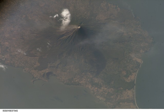
Mission: ISS015 Roll: E Frame: 7543 Mission ID on the Film or image: ISS015Country or Geographic Name: NICARAGUA
Features: CONCEPCION VOLCANO,PLUME
Center Point Latitude: 11.5 Center Point Longitude: -85.6 (Negative numbers indicate south for latitude and west for longitude)
Stereo: (Yes indicates there is an adjacent picture of the same area)
ONC Map ID: JNC Map ID:
Camera
Camera Tilt: High ObliqueCamera Focal Length: 800mm
Camera: E4: Kodak DCS760C Electronic Still Camera
Film: 3060E : 3060 x 2036 pixel CCD, RGBG array.
Quality
Film Exposure:Percentage of Cloud Cover: 10 (0-10)
Nadir
Date: 20070510 (YYYYMMDD)GMT Time: 214329 (HHMMSS)Nadir Point Latitude: 6.5, Longitude: -82.8 (Negative numbers indicate south for latitude and west for longitude)
Nadir to Photo Center Direction: Northwest
Sun Azimuth: 287 (Clockwise angle in degrees from north to the sun measured at the nadir point)
Spacecraft Altitude: 178 nautical miles (330 km)
Sun Elevation Angle: 27 (Angle in degrees between the horizon and the sun, measured at the nadir point)
Orbit Number: 488
Captions
Concepcion Volcano, Nicaragua:Concepción Volcano one of the tallest and most active of Nicaragua’s volcanoes. The 1,610-meter (5,280-foot), cone-shaped volcano is the northern half of dumbbell-shaped Isla de Ometepe. Concepción is joined by a narrow isthmus to the dormant Maderas Volcano, which makes up the southern half of the island. This image of the volcano was captured on May 10, 2007, by the astronauts onboard the International Space Station. To the northwest of the crater, a very faint plume (probably steam) creeps like fog down the mountain, blurring the sharp gullies that carve the volcano’s flanks. The grid pattern of people’s fields surrounds the volcano, while lobes of forest line the lower slopes.
Concepción has erupted at least 25 times in the past 125 years, but eruptions are not the only hazard for the 5,000 or so people who lives in small towns at lower elevations. Loose rock and ash from previous eruptions makes the volcano’s steep slopes unstable and prone to give way during heavy rains. These flows of muddy debris are known as lahars. Among the most serious lahars that have occurred at Concepción in recent years were those that occurred during the passage of Hurricane Mitch through the area in 1998. (Much more serious lahars occurred at Nicaragua’s Casita Volcano during Hurricane Mitch.) The gullies that can funnel debris quickly downslope into populated areas are obvious in the image.
References and Related images:
Lahar Hazards at Concepción Volcano, Nicaragua, a U.S. Geological Survey Webpage
Wide-area view of western Nicaragua, including Lake Nicaragua and Isla Ometepe at lower right, from the Moderate Resolution Imaging Spectroradiometer (MODIS) on NASA’s Terra satellite
Download Packaged File.
This option downloads the following items, packaged into a single file, if they are available:
- Browse image
- Cataloged information with captions
- Camera file
- Sound file
Server: 2 |
This service is provided by the International Space Station program. |
Recommended Citation: |
||

