| Home >> | Advanced Search >> |
 |
|
Astronaut Photography of Earth - Display Record
ISS007-E-7388

Low-resolution Browse Image
(Most browse images are not color adjusted.)Images
Conditions for Use of Images >>Image Transformation Tutorial >> Saving, Color Adjusting, and Printing Images >>
Images to View on Your Computer Now
| File Name | File Size (bytes) | Width | Height | Annotated | Cropped | Purpose | Comments | |
|---|---|---|---|---|---|---|---|---|
| View | ISS007-E-7388.JPG | 54146 | 540 | 355 | Photographic Highlights | (resized 540 px images) | ||
| View | ISS007-E-7388.JPG | 60536 | 540 | 405 | Yes | Yes | NASA's Earth Observatory web site | |
| View | ISS007-E-7388.JPG | 60536 | 540 | 405 | Yes | Yes | NASA's Earth Observatory web site | Color adjusted |
| View | ISS007-E-7388.JPG | 60573 | 639 | 435 | No | No | ||
| View | ISS007-E-7388_2.JPG | 168219 | 999 | 657 | Photographic Highlights | (actual files used) | ||
| View | ISS007-E-7388.JPG | 835500 | 1000 | 660 | No | Yes | NASA's Earth Observatory web site |
Large Images to Request for Downloading
| File Name | File Size (bytes) | Width | Height | Annotated | Cropped | Purpose | Comments | |
|---|---|---|---|---|---|---|---|---|
| Request | ISS007-E-7388.JPG | 871832 | 3032 | 2064 | No | No | ||
| Request | ISS007-E-7388_2.JPG | 4235003 | 6144 | 4068 | No | No | Presentation | Earth Sciences Results Briefing/Ed Lu |
Download a Keyhole Markup Language (KML) file for use in Google Earth.
Electronic Image Data
Camera Files >> No sound file available.Identification
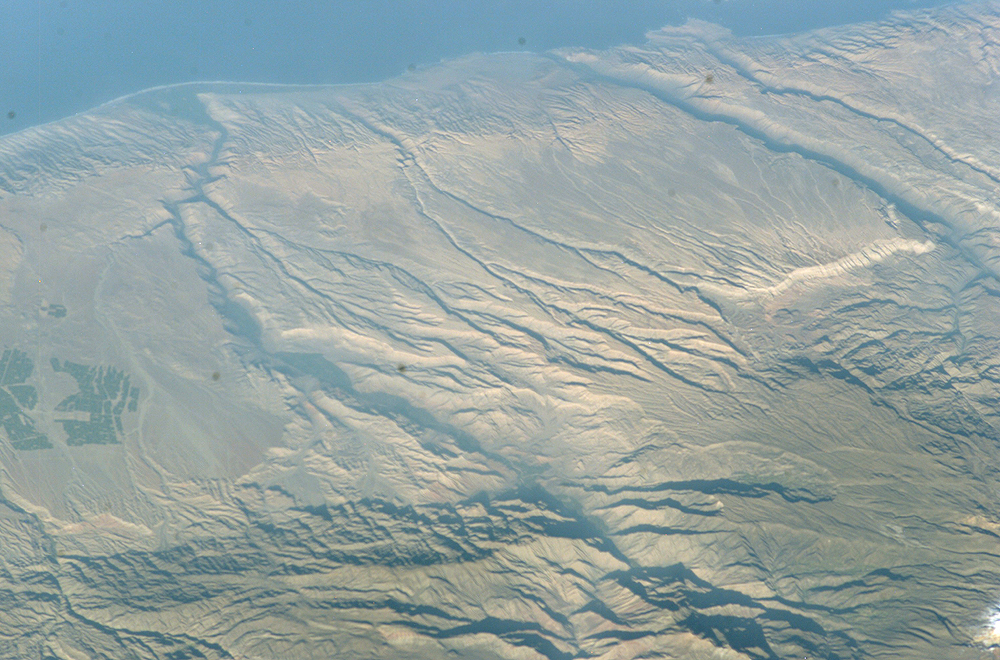
Mission: ISS007 Roll: E Frame: 7388 Mission ID on the Film or image: ISS007Country or Geographic Name: PERU
Features: COLCA RIVER, OCONA RIVER, AGR.
Center Point Latitude: -16.0 Center Point Longitude: -72.5 (Negative numbers indicate south for latitude and west for longitude)
Stereo: (Yes indicates there is an adjacent picture of the same area)
ONC Map ID: JNC Map ID:
Camera
Camera Tilt: 53Camera Focal Length: 180mm
Camera: E4: Kodak DCS760C Electronic Still Camera
Film: 3060E : 3060 x 2036 pixel CCD, RGBG array.
Quality
Film Exposure:Percentage of Cloud Cover: 10 (0-10)
Nadir
Date: 20030614 (YYYYMMDD)GMT Time: 123520 (HHMMSS)Nadir Point Latitude: -13.5, Longitude: -68.5 (Negative numbers indicate south for latitude and west for longitude)
Nadir to Photo Center Direction: Southwest
Sun Azimuth: 58 (Clockwise angle in degrees from north to the sun measured at the nadir point)
Spacecraft Altitude: 211 nautical miles (391 km)
Sun Elevation Angle: 21 (Angle in degrees between the horizon and the sun, measured at the nadir point)
Orbit Number: 2058
Captions
Some of the deepest canyons in the world cut west to the Pacific from the high crest of the Andes Mountains in Peru. This dramatic image taken from the International Space Station provides a birds-eye view down the canyons of the Rio Camana and the Rio Ocona. The low early morning sun highlights the extreme topography created by rapidly uplifting mountains and powerful water erosion by water dropping nearly 10,000 feet (more than 3000 m) in this view. At the edge of the image is the snowy flanks of Nevado Coropuna, the highest mountain in the Cordillera Occidental (6613 meters)The coastal plane provides a small area for cultivating crops. The coastal region near the city of Camana suffered extensive damage from a tsunami in 2001 (http://www.usc.edu/dept/tsunamis/peru01/web%20pages/peru01_camana.html).
Deepest Canyons of the Andes, Camaná, Peru and Tsunami Vulnerability, and Earthquake Epicenter, Peru show other views of this area from space.
Download Packaged File.
This option downloads the following items, packaged into a single file, if they are available:
- Browse image
- Cataloged information with captions
- Camera file
- Sound file
Server: 2 |
This service is provided by the International Space Station program. |
Recommended Citation: |
||

