| Home >> | Advanced Search >> |
 |
|
Astronaut Photography of Earth - Display Record
ISS014-E-7258

Low-resolution Browse Image
(Most browse images are not color adjusted.)Images
Conditions for Use of Images >>Image Transformation Tutorial >> Saving, Color Adjusting, and Printing Images >>
Images to View on Your Computer Now
| File Name | File Size (bytes) | Width | Height | Annotated | Cropped | Purpose | Comments | |
|---|---|---|---|---|---|---|---|---|
| View | ISS014-E-7258.JPG | 69920 | 639 | 435 | No | No | ||
| View | ISS014-E-7258.JPG | 327918 | 540 | 410 | Yes | Yes | NASA's Earth Observatory web site |
Large Images to Request for Downloading
| File Name | File Size (bytes) | Width | Height | Annotated | Cropped | Purpose | Comments | |
|---|---|---|---|---|---|---|---|---|
| Request | ISS014-E-7258.JPG | 945103 | 1000 | 759 | No | Yes | NASA's Earth Observatory web site | |
| Request | ISS014-E-7258.JPG | 1149261 | 3032 | 2064 | No | No |
Download a Keyhole Markup Language (KML) file for use in Google Earth.
Electronic Image Data
Camera Files >> No sound file available.Identification
Mission: ISS014 Roll: E Frame: 7258 Mission ID on the Film or image: ISS014Country or Geographic Name: USA-TEXAS
Features: GALVESTON,BOLIVAR PENINSULA
Center Point Latitude: 29.3 Center Point Longitude: -94.8 (Negative numbers indicate south for latitude and west for longitude)
Stereo: (Yes indicates there is an adjacent picture of the same area)
ONC Map ID: JNC Map ID:
Camera
Camera Tilt: High ObliqueCamera Focal Length: 180mm
Camera: E4: Kodak DCS760C Electronic Still Camera
Film: 3060E : 3060 x 2036 pixel CCD, RGBG array.
Quality
Film Exposure:Percentage of Cloud Cover: 10 (0-10)
Nadir
Date: 20061104 (YYYYMMDD)GMT Time: 040729 (HHMMSS)Nadir Point Latitude: 25.2, Longitude: -120.8 (Negative numbers indicate south for latitude and west for longitude)
Nadir to Photo Center Direction: East
Sun Azimuth: 270 (Clockwise angle in degrees from north to the sun measured at the nadir point)
Spacecraft Altitude: 176 nautical miles (326 km)
Sun Elevation Angle: -38 (Angle in degrees between the horizon and the sun, measured at the nadir point)
Orbit Number: 1524
Captions
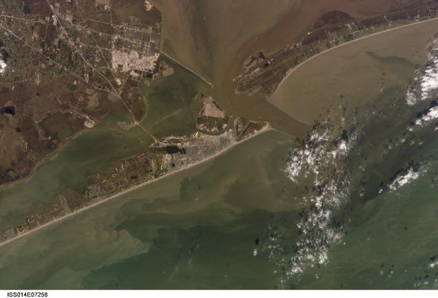
Galveston, Texas:Galveston Island has alternately been a home to Native Americans, a base for Mexico’s rebellion against Spain, a pirate kingdom, a sea port, and even the capital of the Republic of Texas. In September 1900, the city was largely destroyed by a powerful hurricane. This storm damage, combined with construction of the Houston Ship Channel and discovery of oil in eastern Texas, shifted the center of trade northwest to Houston.
This astronaut photograph shows some of the human impacts in Galveston that are easily observed from the vantage point of low-Earth orbit. The city of Galveston dominates the eastern half of Galveston Island, appearing as the gray-white region at center right. A large seawall along the Gulf of Mexico—shown here along the southern coastline of Galveston Island—protects most of the city. To the west of Galveston, coastal wetlands are largely submerged by regional subsidence—sinking of the land as a result of ground water withdrawal by the petrochemical industry of Houston and Texas City.
Near the right edge of this photograph, between Galveston Island and the Bolivar Peninsula, is the entrance to Galveston Bay and the Houston Ship Channel, where ship wakes can be seen from space. Other visible features of the entrance to Galveston Bay include the five-mile-long Texas City Dike, a structure that protects the Texas City Channel and includes a fishing pier extending roughly 180 meters (600 feet) beyond the end of the dike. Extensive petroleum processing facilities are located to the west of the dike in Texas City, and the building roofs and storage tanks appear bright white in this image. The Intracoastal Waterway runs through western Galveston Bay; new subdivisions built on dredge spoils (sediment dredged during canal-building and other projects) are visible along the northern boundary of the Waterway.
Besides land uses and ship wakes, this image shows complex sediment patterns iin estuaries. Dark brown to tan waters next to the Bolivar Peninsula and Texas City Dike reflect increased sediment loads following heavy rains in mid- to late October, coupled with northerly winds moving Bay water southwards. Turbidity currents to both the northwest and southeast of Galveston Island produce a more chaotic pattern of sediment-laden (light green to tan) and relatively sediment-free (dark green) water leading into the dark green Gulf of Mexico (image lower right).
ISS014-E-07258 (4 Nov. 2006) --- Galveston, Texas is featured in this image photographed by an Expedition 14 crewmember on the International Space Station (ISS). Mexico established a port of entry (known as Galveston) in 1825, and following the Texas Revolution it was the capital of the Republic of Texas during 1836. The modern-day city of Galveston was incorporated in 1839, and became the major trading seaport of Texas during the latter half of the 19th century. The city was largely destroyed in early September of 1900 by a powerful hurricane; this, coupled with construction of the Houston Ship Channel and discovery of oil in eastern Texas shifted the center of trade northwest to Houston. Many human footprints are easily observed from the vantage point of low Earth orbit. The eastern half of Galveston Island is dominated by the city of Galveston (gray-white region at center). A large seawall along the Gulf of Mexico (southern coastline of Galveston Island) protects most of the city. To the west of Galveston, coastal wetlands are largely submerged by regional subsidence--a result of ground water withdrawal by the petrochemical industry of Houston and Texas City. The entrance to Galveston Bay and the Houston Ship Channel is located between Galveston Island and the Bolivar Peninsula (upper right). Numerous ship wakes are visible along the Houston Ship Channel. Other visible features of the entrance to Galveston Bay include the five-mile long Texas City Dike, a structure that protects the Texas City channel and includes a fishing pier that extends 600 feet beyond the end of the Dike. Extensive petroleum processing facilities are located to the west of the Dike in Texas City. The Intracoastal Waterway runs through western Galveston Bay; new subdivisions built on dredge spoils are visible along the northern boundary of the Waterway. Geologists studying the ISS collection of downlinked still imagery observe that complex estuarine sediment patterns are visible in this image. Dark brown to tan waters adjacent to the Bolivar Peninsula and Texas City Dike reflect increased sediment loads following heavy rains in mid-to-late October, coupled with northerly winds moving Bay water southwards. Turbidity currents to both the northwest and southeast of Galveston Island produce a more chaotic pattern of sediment-laden (light green to tan) and relatively sediment-free (dark green) water leading into the dark green Gulf of Mexico (lower right).
Download Packaged File.
This option downloads the following items, packaged into a single file, if they are available:
- Browse image
- Cataloged information with captions
- Camera file
- Sound file
Server: 2 |
This service is provided by the International Space Station program. |
Recommended Citation: |
||

