| Home >> | Advanced Search >> |
 |
|
Astronaut Photography of Earth - Display Record
STS105-723-7

Low-resolution Browse Image
(Most browse images are not color adjusted.)Images
Conditions for Use of Images >>Image Transformation Tutorial >> Saving, Color Adjusting, and Printing Images >>
Images to View on Your Computer Now
| File Name | File Size (bytes) | Width | Height | Annotated | Cropped | Purpose | Comments | |
|---|---|---|---|---|---|---|---|---|
| View | STS105-723-7.JPG | 30516 | 515 | 512 | No | No | From ISD PhotoCDs | |
| View | STS105-723-7.JPG | 125763 | 540 | 422 | Yes | Yes | NASA's Earth Observatory web site | |
| View | STS105-723-7.JPG | 240092 | 1296 | 1105 | NASA's Earth Observatory web site | |||
| View | STS105-723-7_2.JPG | 125029 | 400 | 313 | Yes | No | Photographic Highlights |
Large Images to Request for Downloading
| File Name | File Size (bytes) | Width | Height | Annotated | Cropped | Purpose | Comments | |
|---|---|---|---|---|---|---|---|---|
| Request | STS105-723-7.JPG | 95648 | 1030 | 1024 | No | No | From ISD PhotoCDs | |
| Request | STS105-723-7_2.JPG | 305516 | 2063 | 2048 | No | No | From ISD PhotoCDs | |
| Request | STS105-723-7_3.JPG | 908337 | 4127 | 4096 | No | No | From ISD PhotoCDs | |
| Request | STS105-723-7.JPG | 240092 | 1296 | 1105 | No | No | ||
| Request | STS105-723-7_2.TIF | 4495364 | 1253 | 1287 | No | No | ||
| Request | STS105-723-7.TIF | 4906890 | 1308 | 1326 | No | No |
Download a Keyhole Markup Language (KML) file for use in Google Earth.
Electronic Image Data
Camera files only apply to electronic still cameras.No sound file available.
Identification
Mission: STS105 Roll: 723 Frame: 7 Mission ID on the Film or image: STS105Country or Geographic Name: ATLANTIC OCEAN
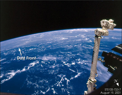
Features: PAN-DUST, CLOUDS
Center Point Latitude: Center Point Longitude: (Negative numbers indicate south for latitude and west for longitude)
Stereo: (Yes indicates there is an adjacent picture of the same area)
ONC Map ID: JNC Map ID:
Camera
Camera Tilt: High ObliqueCamera Focal Length: 110mm
Camera: HB: Hasselblad
Film: 5069 : Kodak Elite 100S, E6 Reversal, Replaces Lumiere, Warmer in tone vs. Lumiere.
Quality
Film Exposure:Percentage of Cloud Cover: 50 (26-50)
Nadir
Date: 20010819 (YYYYMMDD)GMT Time: (HHMMSS)Nadir Point Latitude: , Longitude: (Negative numbers indicate south for latitude and west for longitude)
Nadir to Photo Center Direction:
Sun Azimuth: (Clockwise angle in degrees from north to the sun measured at the nadir point)
Spacecraft Altitude: nautical miles (0 km)
Sun Elevation Angle: (Angle in degrees between the horizon and the sun, measured at the nadir point)
Orbit Number:
Captions
Shuttle astronauts frequently track Saharan dust storms as they blow from north Africa across the Atlantic Ocean. Dust palls blowing from Africa take about a week to cross the Atlantic. Recently, researchers have linked Saharan dust to coral disease, allergic reactions in humans, and red tides. The photograph was taken by Space Shuttle astronauts while docked to the International Space Station on August 19, 2001. The spacecraft is over the Atlantic Ocean at roughly 45°N, 60°W. The astronauts were looking obliquely to the south; the boundaries of the dust plumes can be traced visually by the abrupt change from clear to hazy atmosphere-the hazy line marks the northern edge of the dust pall near the Caribbean.Download Packaged File.
This option downloads the following items, packaged into a single file, if they are available:
- Browse image
- Cataloged information with captions
- Camera file
- Sound file
Server: 2 |
This service is provided by the International Space Station program. |
Recommended Citation: |
||

