| Home >> | Advanced Search >> |
 |
|
Astronaut Photography of Earth - Display Record
ISS010-E-6681
Low-resolution Browse Image
(Most browse images are not color adjusted.)Images
Conditions for Use of Images >>Image Transformation Tutorial >> Saving, Color Adjusting, and Printing Images >>
Images to View on Your Computer Now
| File Name | File Size (bytes) | Width | Height | Annotated | Cropped | Purpose | Comments | |
|---|---|---|---|---|---|---|---|---|
| View | ISS010-E-6681.JPG | 50106 | 639 | 435 | No | No | ||
| View | ISS010-E-6681.JPG | 511047 | 540 | 719 | Yes | Yes | Earth From Space collection | |
| View | ISS010-E-6681.JPG | 1101799 | 1000 | 1332 | No | Yes | NASA's Earth Observatory web site |
Large Images to Request for Downloading
| File Name | File Size (bytes) | Width | Height | Annotated | Cropped | Purpose | Comments | |
|---|---|---|---|---|---|---|---|---|
| Request | ISS010-E-6681.JPG | 801308 | 3032 | 2064 | No | No |
Download a Keyhole Markup Language (KML) file for use in Google Earth.
Electronic Image Data
Camera Files >> No sound file available.Identification
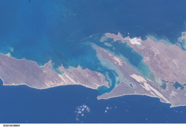
Mission: ISS010 Roll: E Frame: 6681 Mission ID on the Film or image: ISS010Country or Geographic Name: AUSTRALIA-WA
Features: DIRK HARTOG I., USELESS INLET
Center Point Latitude: -26.0 Center Point Longitude: 113.0 (Negative numbers indicate south for latitude and west for longitude)
Stereo: (Yes indicates there is an adjacent picture of the same area)
ONC Map ID: JNC Map ID:
Camera
Camera Tilt: 33Camera Focal Length: 180mm
Camera: E4: Kodak DCS760C Electronic Still Camera
Film: 3060E : 3060 x 2036 pixel CCD, RGBG array.
Quality
Film Exposure:Percentage of Cloud Cover: 10 (0-10)
Nadir
Date: 20041112 (YYYYMMDD)GMT Time: 063853 (HHMMSS)Nadir Point Latitude: -27.3, Longitude: 114.6 (Negative numbers indicate south for latitude and west for longitude)
Nadir to Photo Center Direction: Northwest
Sun Azimuth: 277 (Clockwise angle in degrees from north to the sun measured at the nadir point)
Spacecraft Altitude: 191 nautical miles (354 km)
Sun Elevation Angle: 54 (Angle in degrees between the horizon and the sun, measured at the nadir point)
Orbit Number: 2157
Captions
Shark Bay, AustraliaThis image shows large solar salt works developed in Useless Loop and Useless Inlet, Shark Bay, Western Australia (for a regional image of Shark Bay, see Phytoplankton in Shark Bay ). The salt (sodium chloride) is produced when ponds are repeatedly flooded with seawater, which is progressively concentrated by evaporation. This particular salt farm opened in 1967 and expanded operations in the 1990s. Today, this salt farm comprises over 50 ponds’the newest pond is the outermost pond in Useless Inlet, which provides the first evaporation cycle to increase the salinity of the water prior to entering the next pond. Complex chemical and biological adjustments occur in the system each time the configuration of ponds is changed.
Solar salt production has increased along the world’s arid coastal regions. Global demand for salt is on the rise, primarily because salt is a basic feedstock to the chemical industry (the largest salt consumer). Commercial solar salt ponds are frequently controversial components of coastal ecosystems. The hypersaline conditions are toxic to preexisting ecosystems in and around the converted land, and valuable coastal wetlands may be impacted by flooding, changing water levels and salinities. However, salt ponds have also been successfully converted to wetlands, and the shallow ponds can support shellfish and bird populations.
Download Packaged File.
This option downloads the following items, packaged into a single file, if they are available:
- Browse image
- Cataloged information with captions
- Camera file
- Sound file
Server: 2 |
This service is provided by the International Space Station program. |
Recommended Citation: |
||

