| Home >> | Advanced Search >> |
 |
|
Astronaut Photography of Earth - Display Record
ISS013-E-66488

Low-resolution Browse Image
(Most browse images are not color adjusted.)Images
Conditions for Use of Images >>Image Transformation Tutorial >> Saving, Color Adjusting, and Printing Images >>
Images to View on Your Computer Now
| File Name | File Size (bytes) | Width | Height | Annotated | Cropped | Purpose | Comments | |
|---|---|---|---|---|---|---|---|---|
| View | ISS013-E-66488.JPG | 68589 | 639 | 435 | No | No | ||
| View | ISS013-E-66488_2.JPG | 85744 | 540 | 720 | Yes | NASA's Earth Observatory web site | ||
| View | ISS013-E-66488.JPG | 235130 | 357 | 540 | Yes | Yes | NASA's Earth Observatory web site |
Large Images to Request for Downloading
| File Name | File Size (bytes) | Width | Height | Annotated | Cropped | Purpose | Comments | |
|---|---|---|---|---|---|---|---|---|
| Request | ISS013-E-66488.JPG | 624528 | 1000 | 661 | No | Yes | NASA's Earth Observatory web site | |
| Request | ISS013-E-66488.JPG | 967538 | 3032 | 2064 | No | No |
Download a Keyhole Markup Language (KML) file for use in Google Earth.
Electronic Image Data
Camera Files >> No sound file available.Identification
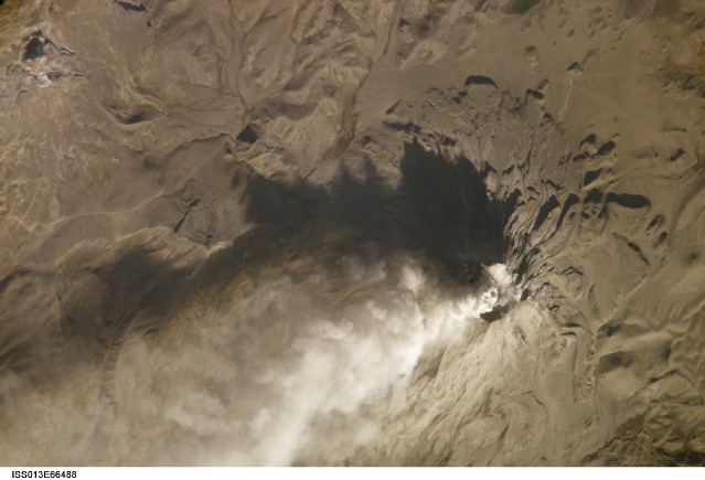
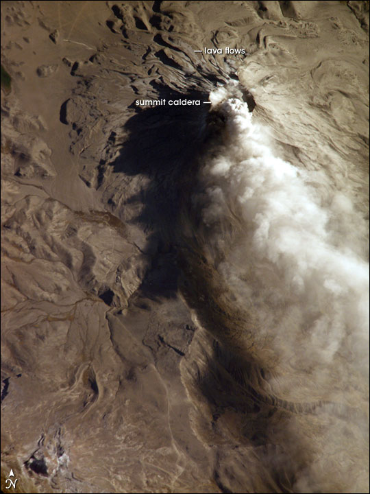
Mission: ISS013 Roll: E Frame: 66488 Mission ID on the Film or image: ISS013Country or Geographic Name: PERU
Features: UBINAS VOLCANO,ASH CLOUD
Center Point Latitude: -16.3 Center Point Longitude: -70.9 (Negative numbers indicate south for latitude and west for longitude)
Stereo: (Yes indicates there is an adjacent picture of the same area)
ONC Map ID: JNC Map ID:
Camera
Camera Tilt: 38Camera Focal Length: 800mm
Camera: E4: Kodak DCS760C Electronic Still Camera
Film: 3060E : 3060 x 2036 pixel CCD, RGBG array.
Quality
Film Exposure:Percentage of Cloud Cover: 10 (0-10)
Nadir
Date: 20060814 (YYYYMMDD)GMT Time: 124359 (HHMMSS)Nadir Point Latitude: -18.6, Longitude: -71.6 (Negative numbers indicate south for latitude and west for longitude)
Nadir to Photo Center Direction: North
Sun Azimuth: 66 (Clockwise angle in degrees from north to the sun measured at the nadir point)
Spacecraft Altitude: 183 nautical miles (339 km)
Sun Elevation Angle: 21 (Angle in degrees between the horizon and the sun, measured at the nadir point)
Orbit Number: 236
Captions
Ash Cloud from Mount Ubinas, PeruSubduction of the Nazca tectonic plate along the western coast of South America forms the high Peruvian Andes. The subduction (movement of one plate beneath another) also produces magma, feeding a chain of historically active volcanoes along the western front of the mountains. The most active of these volcanoes in Peru is Ubinas. A typical, steep-sided stratovolcano comprised primarily of layers of silica-rich lava flows, it has a summit elevation of 5,672 meters (18,609 feet). At 1.4 kilometers (0.87 miles) across, the volcano’s caldera gives it a truncated profile. Hardened lava flows from past eruptions linger on the volcano’s flanks.
This oblique image (looking at an angle) from the International Space Station (ISS) captures an ash cloud first observed on satellite imagery at 11:00 GMT on August 14, 2006. An ISS astronaut took this picture one hour and 45 minutes later. The ash cloud caused the Buenos Aires Volcanic Ash Advisory Center to issue an aviation hazard warning. Minor to moderately explosive eruptions of ash and pumice characterize modern activity at Ubinas. Pumice and ash blanket the volcanic cone and surrounding area, giving this image an overall gray appearance. Shadowing of the western flank of Ubinas throws several lava flows into sharp relief, and highlights the steep slopes at the flow fronts—common characteristics of thick, slow-moving lavas. The most recent major eruption of Ubinas occurred in 1969, although its historical record of activity extends back to the 16th century.
Download Packaged File.
This option downloads the following items, packaged into a single file, if they are available:
- Browse image
- Cataloged information with captions
- Camera file
- Sound file
Server: 2 |
This service is provided by the International Space Station program. |
Recommended Citation: |
||

