| Home >> | Advanced Search >> |
 |
|
Astronaut Photography of Earth - Display Record
STS075-773-66
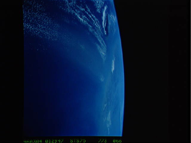
Low-resolution Browse Image
(Most browse images are not color adjusted.)Images
Conditions for Use of Images >>Image Transformation Tutorial >> Saving, Color Adjusting, and Printing Images >>
Images to View on Your Computer Now
| File Name | File Size (bytes) | Width | Height | Annotated | Cropped | Purpose | Comments | |
|---|---|---|---|---|---|---|---|---|
| View | STS075-773-66.JPG | 18701 | 640 | 480 | No | No | ISD 1 | |
| View | STS075-773-66.JPG | 46297 | 540 | 405 | Yes | Yes | NASA's Earth Observatory web site | Color adjusted |
| View | STS075-773-66.JPG | 46297 | 540 | 405 | Yes | Yes | NASA's Earth Observatory web site | |
| View | STS075-773-66.JPG | 1119469 | 1000 | 977 | No | No | NASA's Earth Observatory web site | |
| View | STS075-773-66.BMP | 271926 | 512 | 529 | Yes | No |
Large Images to Request for Downloading
| File Name | File Size (bytes) | Width | Height | Annotated | Cropped | Purpose | Comments | |
|---|---|---|---|---|---|---|---|---|
| Request | STS075-773-66.TIF | 7736802 | 1890 | 1934 | No | No |
Download a Keyhole Markup Language (KML) file for use in Google Earth.
Electronic Image Data
Camera files only apply to electronic still cameras.No sound file available.
Identification
Mission: STS075 Roll: 773 Frame: 66 Mission ID on the Film or image: STS75Country or Geographic Name: PACIFIC OCEAN
Features: PAN-VIEW TO FORMOSA STR.
Center Point Latitude: Center Point Longitude: (Negative numbers indicate south for latitude and west for longitude)
Stereo: No (Yes indicates there is an adjacent picture of the same area)
ONC Map ID: H-13 JNC Map ID: 38
Camera
Camera Tilt: High ObliqueCamera Focal Length: 40mm
Camera: HB: Hasselblad
Film: VELVI : Fuji, natural color positive, Velvia 50, CS 135-36, ASA 32, standard base.
Quality
Film Exposure: NormalPercentage of Cloud Cover: 20 (11-25)
Nadir
Date: 19960304 (YYYYMMDD)GMT Time: 012947 (HHMMSS)Nadir Point Latitude: 28.0, Longitude: 128.1 (Negative numbers indicate south for latitude and west for longitude)
Nadir to Photo Center Direction:
Sun Azimuth: 133 (Clockwise angle in degrees from north to the sun measured at the nadir point)
Spacecraft Altitude: 150 nautical miles (278 km)
Sun Elevation Angle: 44 (Angle in degrees between the horizon and the sun, measured at the nadir point)
Orbit Number: 164
Captions
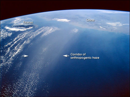
Greenhouse gases act broadly to warm the atmosphere, but human-induced aerosols (particles in the atmosphere) generate negative forcings—that is cooling of the atmosphere by reflection of the sun’s energy away from Earth. The above photograph from the Space Shuttle was featured in an article in Science magazine this week (Science vol. 300: 1103-1104). It shows haze from China spread over the Pacific Ocean, on March 4, 1996.In the Science article, Anderson and coworkers point out that greenhouse gas forcing on climate is fairly well understood, but the effect of aerosols is not. Two ways of estimating the "forcing," or push, on global climate caused by aerosols give inconsistent results. So-called "inverse" calculations constrain such cooling to a range of –1.0 to –1.9 Watts per square meter, whereas "forward" calculations suggest far greater negative forcing, as much as –3 W/m2 or more. Photographs taken by astronauts illustrate the kind of reflective smog plumes that cause surface cooling.
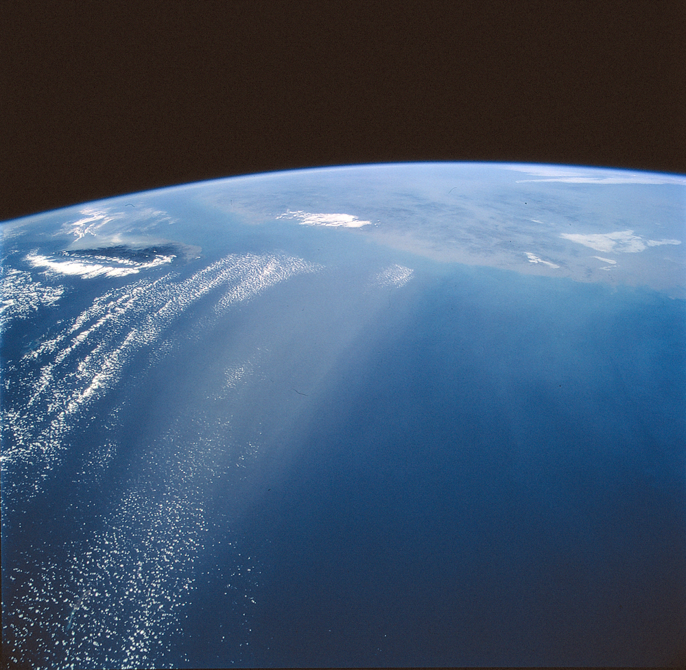
The photograph shows a coherent corridor of anthropogenic haze (arrows), probably a mixture of industrial air pollution, dust, and smoke, in the left half of the view against the dark background of the East China Sea (Wilkinson et al. 2000). The corridor is ~200 km wide and probably much more than 600 km long (the visible length over the sea). In this southwest-looking view, the island of Taiwan appears top left and the east coast of China across the rest of the view. The picture was taken as the Space Shuttle flew over Okinawa. Shanghai lies at the near point on the Chinese coastline (top right)—about 650 km away. The transport of smog from East Asia has been confirmed in measurements of the atmosphere over North America.
The uncertainty in understanding aerosol forcing of global temperature means that its effect in counteracting greenhouse-gas warming is still largely unknown. The Science article concludes that the 0.6 Kelvin rise in average global surface temperature in the last 130 years may be due to natural variability in the atmosphere that could be far higher than currently understood; and/or to much higher sensitivity in the climate system. The article nevertheless concludes that by the middle of this century the absolute accumulation of greenhouse gases, compared to the non-accumulation of aerosols, "will inevitably result in a strong, positive forcing of Earth’s climate system".
References
Anderson, T. L., R. J. Charlson, S. E. Schwartz, R. Knutti, O. Boucher, H. Rodhe, and J. Heitzenberg, 2003, Climate forcing by aerosols—a hazy picture, Science (16 May 2003) 300: 1103-1104.
M. J. Wilkinson, M. J., J. D. Wheeler, R. J. Charlson, and K. P. Lulla, 2000, Imaging Aerosols from Low Earth Orbit: Photographic Results From the Shuttle-Mir and Shuttle Programs, in K. P. Lulla and L. V. Dessinov (ed.) Dynamic Earth Environments, New York: Wiley. Ch. 6.
NASA photograph STS075-773-66, was taken March 4, 1996, 01:29:47 GMT, center point 28°N 123°E, craft nadir 28°N 128.1°W, from an altitude of 278 km, with a Hasselblad film camera and 40 mm lens.
Download Packaged File.
This option downloads the following items, packaged into a single file, if they are available:
- Browse image
- Cataloged information with captions
- Camera file
- Sound file
Server: 2 |
This service is provided by the International Space Station program. |
Recommended Citation: |
||

