| Home >> | Advanced Search >> |
 |
|
Astronaut Photography of Earth - Display Record
STS028-96-65

Low-resolution Browse Image
(Most browse images are not color adjusted.)Images
Conditions for Use of Images >>Image Transformation Tutorial >> Saving, Color Adjusting, and Printing Images >>
Images to View on Your Computer Now
| File Name | File Size (bytes) | Width | Height | Annotated | Cropped | Purpose | Comments | |
|---|---|---|---|---|---|---|---|---|
| View | STS028-96-65.JPG | 45720 | 640 | 480 | No | No | ISD 1 | |
| View | STS028-96-65.JPG | 115790 | 540 | 437 | Yes | Yes | NASA's Earth Observatory web site | |
| View | STS028-96-65.JPG | 203701 | 448 | 442 | Photographic Highlights | |||
| View | STS028-96-65.JPG | 2520813 | 1286 | 1316 | NASA's Earth Observatory web site | |||
| View | STS028-96-65_2.JPG | 262489 | 400 | 409 | No | Yes | Photographic Highlights |
Large Images to Request for Downloading
| File Name | File Size (bytes) | Width | Height | Annotated | Cropped | Purpose | Comments | |
|---|---|---|---|---|---|---|---|---|
| Request | STS028-96-65.JPG | 2520813 | 1286 | 1316 | No | Yes | NASA's Earth Observatory web site | |
| Request | STS028-96-65.TIF | 52028392 | 4774 | 4665 | No | No |
Download a Keyhole Markup Language (KML) file for use in Google Earth.
Electronic Image Data
Camera files only apply to electronic still cameras.No sound file available.
Identification
Mission: STS028 Roll: 96 Frame: 65 Mission ID on the Film or image: STS28Country or Geographic Name: JORDAN
Features: DEAD SEA, WADI JEIB
Center Point Latitude: 31.0 Center Point Longitude: 35.5 (Negative numbers indicate south for latitude and west for longitude)
Stereo: Yes (Yes indicates there is an adjacent picture of the same area)
ONC Map ID: JNC Map ID:
Camera
Camera Tilt: 26Camera Focal Length: 250mm
Camera: HB: Hasselblad
Film: 5017 : Kodak, natural color positive, Ektachrome, X Professional, ASA 64, standard base.
Quality
Film Exposure: NormalPercentage of Cloud Cover: 0 (0-10)
Nadir
Date: 19890810 (YYYYMMDD)GMT Time: 132602 (HHMMSS)Nadir Point Latitude: 30.1, Longitude: 34.5 (Negative numbers indicate south for latitude and west for longitude)
Nadir to Photo Center Direction: Northeast
Sun Azimuth: 267 (Clockwise angle in degrees from north to the sun measured at the nadir point)
Spacecraft Altitude: 164 nautical miles (304 km)
Sun Elevation Angle: 38 (Angle in degrees between the horizon and the sun, measured at the nadir point)
Orbit Number: 33
Captions
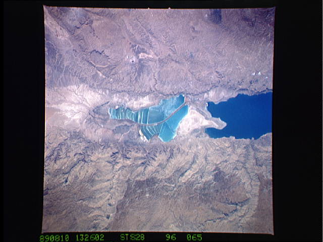
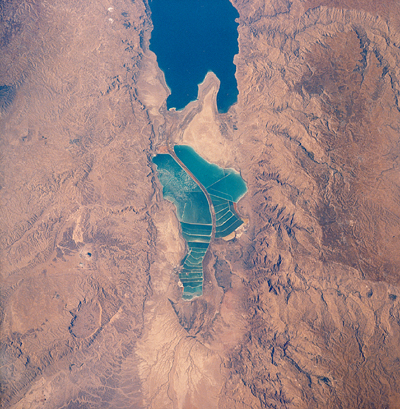
STS028-96-65 Salt Evaporation Ponds, Dead SeaThe complex of Jordanian salt evaporation ponds at the southern end of the Dead Sea has expanded significantly over the past dozen years. The western margin of the salt ponds marks the Jordan-Israel border. In August 1989, when the crew of Space Shuttle mission STS28 photographed the region, the northern extension did not exist and the large polygonal ponds in the northwestern and northeastern sectors had not been subdivided. In the view taken by the STS102 crew in March 2001, one can see that there has also been expansion at the southeastern end, and that levees now segment the northeastern wedge into four ponds.
Both sodium chloride and potassium salts are produced from the Dead Sea ponds. Salt-evaporation works are expanding throughout the world in response to increased manufacture of polyvinyl chloride (PVC) and other chemicals, for which salt is a principal feedstock. About 22.4 million metric tons of salt (sodium chloride) were consumed by the chemical industry in 1996. Other uses are in human and animal nutrition, water conditioning, and road de-icing.
Link to Earth Observatory Caption >>
Download Packaged File.
This option downloads the following items, packaged into a single file, if they are available:
- Browse image
- Cataloged information with captions
- Camera file
- Sound file
Server: 2 |
This service is provided by the International Space Station program. |
Recommended Citation: |
||

