| Home >> | Advanced Search >> |
 |
|
Astronaut Photography of Earth - Display Record
ISS013-E-63766

Low-resolution Browse Image
(Most browse images are not color adjusted.)Images
Conditions for Use of Images >>Image Transformation Tutorial >> Saving, Color Adjusting, and Printing Images >>
Images to View on Your Computer Now
| File Name | File Size (bytes) | Width | Height | Annotated | Cropped | Purpose | Comments | |
|---|---|---|---|---|---|---|---|---|
| View | ISS013-E-63766.JPG | 91280 | 639 | 435 | No | No | ||
| View | ISS013-E-63766.JPG | 300948 | 540 | 374 | Yes | Yes | NASA's Earth Observatory web site |
Large Images to Request for Downloading
| File Name | File Size (bytes) | Width | Height | Annotated | Cropped | Purpose | Comments | |
|---|---|---|---|---|---|---|---|---|
| Request | ISS013-E-63766.JPG | 889374 | 1000 | 693 | No | Yes | NASA's Earth Observatory web site | |
| Request | ISS013-E-63766.JPG | 1296662 | 3032 | 2064 | No | No |
Download a Keyhole Markup Language (KML) file for use in Google Earth.
Electronic Image Data
Camera Files >> No sound file available.Identification
Mission: ISS013 Roll: E Frame: 63766 Mission ID on the Film or image: ISS013Country or Geographic Name: USA-MONTANA
Features: BUTTE,BERKELEY PIT,COPPER MINE
Center Point Latitude: 46.0 Center Point Longitude: -112.4 (Negative numbers indicate south for latitude and west for longitude)
Stereo: (Yes indicates there is an adjacent picture of the same area)
ONC Map ID: JNC Map ID:
Camera
Camera Tilt: 22Camera Focal Length: 800mm
Camera: E4: Kodak DCS760C Electronic Still Camera
Film: 3060E : 3060 x 2036 pixel CCD, RGBG array.
Quality
Film Exposure:Percentage of Cloud Cover: 10 (0-10)
Nadir
Date: 20060802 (YYYYMMDD)GMT Time: 155122 (HHMMSS)Nadir Point Latitude: 44.8, Longitude: -112.2 (Negative numbers indicate south for latitude and west for longitude)
Nadir to Photo Center Direction: North
Sun Azimuth: 101 (Clockwise angle in degrees from north to the sun measured at the nadir point)
Spacecraft Altitude: 178 nautical miles (330 km)
Sun Elevation Angle: 36 (Angle in degrees between the horizon and the sun, measured at the nadir point)
Orbit Number: 49
Captions
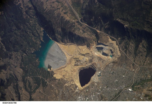
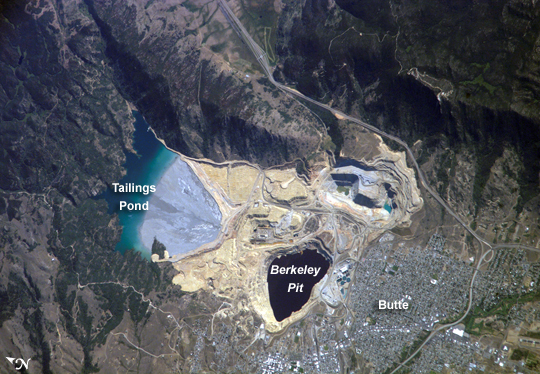
Berkeley Pit: Butte, MontanaMined for gold, silver, and copper, the region of Butte, Montana, had already earned the nickname of “The Richest Hill on Earth” by the end of the 19th century. Demand for electricity increased demand for copper so much that by World War I, the city of Butte was a boomtown. Well before World War I, however, copper mining had spurred the creation of an intricate complex of underground drains and pumps to lower the groundwater level and continue the extraction of copper. Water extracted from the mines was so rich in dissolved copper sulfate that it was also “mined” (by chemical precipitation) for the copper it contained. In 1955, copper mining in the area expanded with the opening of the Berkeley Pit. The mine took advantage of the existing subterranean drainage and pump network to lower groundwater until 1982, when a new owner suspended operations. After the pumps were turned off, water from the surrounding rock basin began seeping into the pit. By the time an astronaut on the International Space Station took this picture on August 2, 2006, water in the pit was more than 275 meters (900 feet) deep.
This image shows many features of the mine workings, such as the terraced levels and access roadways of the open mine pits (gray and tan sculptured surfaces). A large gray tailings pile of waste rock and an adjacent tailings pond appear to the north of the Berkeley Pit. Color changes in the tailings pond result primarily from changing water depth. Because its water contains high concentrations of metals such as copper and zinc, the Berkeley Pit is listed as a federal Superfund site. The Berkeley Pit receives groundwater flowing through the surrounding bedrock and acts as a “terminal pit” or sink for these heavy-metal-laden waters, which can be as strong as battery acid. Ongoing clean-up efforts include treating and diverting water at locations upstream of the pit to reduce inflow and decrease the risk of accidental release of contaminated water from the pit into local aquifers or surface streams.
Download Packaged File.
This option downloads the following items, packaged into a single file, if they are available:
- Browse image
- Cataloged information with captions
- Camera file
- Sound file
Server: 2 |
This service is provided by the International Space Station program. |
Recommended Citation: |
||

