| Home >> | Advanced Search >> |
 |
|
Astronaut Photography of Earth - Display Record
STS112-E-6329

Low-resolution Browse Image
(Most browse images are not color adjusted.)Images
Conditions for Use of Images >>Image Transformation Tutorial >> Saving, Color Adjusting, and Printing Images >>
Images to View on Your Computer Now
| File Name | File Size (bytes) | Width | Height | Annotated | Cropped | Purpose | Comments | |
|---|---|---|---|---|---|---|---|---|
| View | STS112-E-6329.JPG | 78235 | 639 | 435 | No | No | ||
| View | STS112-E-6329.JPG | 254629 | 540 | 768 | Yes | Yes | NASA's Earth Observatory web site | |
| View | STS112-E-6329.JPG | 270170 | 540 | 405 | Photographic Highlights | 540 px resized image | ||
| View | STS112-E-6329.JPG | 1929147 | 1000 | 1469 | No | No | NASA's Earth Observatory web site |
Large Images to Request for Downloading
| File Name | File Size (bytes) | Width | Height | Annotated | Cropped | Purpose | Comments | |
|---|---|---|---|---|---|---|---|---|
| Request | STS112-E-6329.JPG | 879387 | 1024 | 768 | Photographic Highlights | actual image used | ||
| Request | STS112-E-6329.JPG | 1798013 | 3032 | 2064 | No | No |
Download a Keyhole Markup Language (KML) file for use in Google Earth.
Electronic Image Data
Camera Files >> No sound file available.Identification
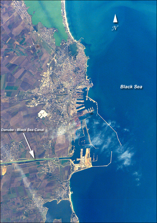
Mission: STS112 Roll: E Frame: 6329 Mission ID on the Film or image: STS112Country or Geographic Name: ROMANIA
Features: CONSTANTA, PORT FACILITIES
Center Point Latitude: 44.0 Center Point Longitude: 28.5 (Negative numbers indicate south for latitude and west for longitude)
Stereo: (Yes indicates there is an adjacent picture of the same area)
ONC Map ID: JNC Map ID:
Camera
Camera Tilt: 32Camera Focal Length: 400mm
Camera: E4: Kodak DCS760C Electronic Still Camera
Film: 3060E : 3060 x 2036 pixel CCD, RGBG array.
Quality
Film Exposure:Percentage of Cloud Cover: 10 (0-10)
Nadir
Date: 20021017 (YYYYMMDD)GMT Time: 103812 (HHMMSS)Nadir Point Latitude: 45.7, Longitude: 27.3 (Negative numbers indicate south for latitude and west for longitude)
Nadir to Photo Center Direction: Southeast
Sun Azimuth: 193 (Clockwise angle in degrees from north to the sun measured at the nadir point)
Spacecraft Altitude: 202 nautical miles (374 km)
Sun Elevation Angle: 34 (Angle in degrees between the horizon and the sun, measured at the nadir point)
Orbit Number: 152
Captions
The modern city of Constanta, with a population of more than 348,000, is located on the western coast of the Black Sea and is the principal seaport for Romania. It is the site of the ancient Greek city of Tomis, colonized in the 6th century B.C. In the 1st century A.D. Tomis became a flourishing provincial capital of the Roman Empire when it acquired its current name from the emperor Constantine I. Today, Constanta is a thriving port-of-entry for Romania, offering both tourist attractions and an expanding, modern port facility that is among the largest on the Black Sea. The crew of STS-112 acquired this detailed digital image of the city on October 17, 2002, using a 400-mm lens. The older part of the city is situated near the large coastal lagoon to the north, while to the south the port facilities are connected to the Danube River’s import shipping commerce via the 64-km Danube – Black Sea Canal. Agricultural fields of mostly wheat and barley extend almost to the shorelines.Download Packaged File.
This option downloads the following items, packaged into a single file, if they are available:
- Browse image
- Cataloged information with captions
- Camera file
- Sound file
Server: 2 |
This service is provided by the International Space Station program. |
Recommended Citation: |
||

