| Home >> | Advanced Search >> |
 |
|
Astronaut Photography of Earth - Display Record
ISS007-E-6305

Low-resolution Browse Image
(Most browse images are not color adjusted.)Images
Conditions for Use of Images >>Image Transformation Tutorial >> Saving, Color Adjusting, and Printing Images >>
Images to View on Your Computer Now
| File Name | File Size (bytes) | Width | Height | Annotated | Cropped | Purpose | Comments | |
|---|---|---|---|---|---|---|---|---|
| View | ISS007-E-6305.JPG | 57258 | 639 | 435 | No | No | ||
| View | ISS007-E-6305.JPG | 84663 | 540 | 354 | Photographic Highlights | (resized 540 px images) | ||
| View | ISS007-E-6305.JPG | 87934 | 540 | 405 | Yes | No | NASA's Earth Observatory web site | |
| View | ISS007-E-6305_2.JPG | 338611 | 997 | 654 | Photographic Highlights | (actual files used) | ||
| View | ISS007-E-6305.JPG | 639872 | 1000 | 659 | NASA's Earth Observatory web site |
Large Images to Request for Downloading
| File Name | File Size (bytes) | Width | Height | Annotated | Cropped | Purpose | Comments | |
|---|---|---|---|---|---|---|---|---|
| Request | ISS007-E-6305.JPG | 890358 | 3032 | 2064 | No | No | ||
| Request | ISS007-E-6305_2.JPG | 6021949 | 6144 | 4068 | No | No | Presentation | Earth Sciences Results Briefing/Ed Lu |
Download a Keyhole Markup Language (KML) file for use in Google Earth.
Electronic Image Data
Camera Files >> No sound file available.Identification
Mission: ISS007 Roll: E Frame: 6305 Mission ID on the Film or image: ISS007Country or Geographic Name: DEM. REP. OF CONGO
Features: CONGO RIVER, BRAZZAVILLE, KINSHASA
Center Point Latitude: -4.5 Center Point Longitude: 15.5 (Negative numbers indicate south for latitude and west for longitude)
Stereo: (Yes indicates there is an adjacent picture of the same area)
ONC Map ID: JNC Map ID:
Camera
Camera Tilt: 26Camera Focal Length: 180mm
Camera: E4: Kodak DCS760C Electronic Still Camera
Film: 3060E : 3060 x 2036 pixel CCD, RGBG array.
Quality
Film Exposure:Percentage of Cloud Cover: 10 (0-10)
Nadir
Date: 20030606 (YYYYMMDD)GMT Time: 105110 (HHMMSS)Nadir Point Latitude: -3.0, Longitude: 14.6 (Negative numbers indicate south for latitude and west for longitude)
Nadir to Photo Center Direction: Southeast
Sun Azimuth: 5 (Clockwise angle in degrees from north to the sun measured at the nadir point)
Spacecraft Altitude: 213 nautical miles (394 km)
Sun Elevation Angle: 64 (Angle in degrees between the horizon and the sun, measured at the nadir point)
Orbit Number: 1932
Captions
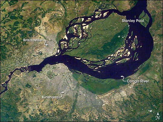
Kinshasa and Brazzaville:This image, taken from the International Space Station on June 6, 2003, shows two capital cities on opposite banks of the Congo River. The smaller city is Brazzaville on the north side of the river, and Kinshasa on the south side. The cities lie at the downstream end of an almost circular widening in the river known as Stanley Pool. The international boundary follows the south shore of the pool (roughly 30 km in diameter).
The Republic of the Congo, originally a French colony, is sometimes called Congo-Brazzaville—as opposed to the Democratic Republic of the Congo (known from 1971 to 1999 as Zaire) which is often called Congo-Kinshasa, originally a Belgian colony. Brazzaville has a population of 600,000, compared with Kinshasa’s 6.8 million. Kinshasa’s population has more than doubled in 20 years—2.7 million in 1984 and 6.8 million in 2004. Kinshasa is thus now far larger than the entire Congo-Brazzaville republic, which has a population of almost 3 million. There is no bridge between the cities so that water craft of many kinds ply between them. It is not uncommon to see dugout canoes being paddled between the cities.
The Congo River drains the vast equatorial Congo Basin, and discharges 35,000-40,000 cubic meters per second of water at Stanley Pool (by comparison, the Nile River discharges 2,500-3,500 cubic meters per second at Aswan). The Congo River exits the pool through a markedly narrowed channel at a series of whitewater rapids that can be seen in this view from space.
Download Packaged File.
This option downloads the following items, packaged into a single file, if they are available:
- Browse image
- Cataloged information with captions
- Camera file
- Sound file
Server: 2 |
This service is provided by the International Space Station program. |
Recommended Citation: |
||

