| Home >> | Advanced Search >> |
 |
|
Astronaut Photography of Earth - Display Record
STS110-726-6
Low-resolution Browse Image
(Most browse images are not color adjusted.)Images
Conditions for Use of Images >>Image Transformation Tutorial >> Saving, Color Adjusting, and Printing Images >>
Images to View on Your Computer Now
| File Name | File Size (bytes) | Width | Height | Annotated | Cropped | Purpose | Comments | |
|---|---|---|---|---|---|---|---|---|
| View | STS110-726-6.JPG | 82698 | 540 | 439 | Yes | Yes | NASA's Earth Observatory web site | |
| View | STS110-726-6.JPG | 116825 | 639 | 639 | Photographic Highlights | added to Mission Highlights | ||
| View | STS110-726-6_2.JPG | 386803 | 540 | 540 | Photographic Highlights | 541 px resized images | ||
| View | STS110-726-6.JPG | 555210 | 768 | 768 | Photographic Highlights | actual files used | ||
| View | STS110-726-6.JPG | 1619845 | 1000 | 1000 | No | Yes | NASA's Earth Observatory web site | color adjusted |
| View | STS110-726-6.TIF | 2197055 | 875 | 836 | No | No | Photographic Highlights |
Large Images to Request for Downloading
| File Name | File Size (bytes) | Width | Height | Annotated | Cropped | Purpose | Comments | |
|---|---|---|---|---|---|---|---|---|
| Request | STS110-726-6.JPG | 1418020 | 4600 | 4400 | No | No | Photographic Highlights | |
| Request | STS110-726-6.JPG | 3325555 | 4088 | 4088 | Public Affairs Office (PAO) |
Download a Keyhole Markup Language (KML) file for use in Google Earth.
Electronic Image Data
Camera files only apply to electronic still cameras.No sound file available.
Identification
Mission: STS110 Roll: 726 Frame: 6 Mission ID on the Film or image: STS110Country or Geographic Name: NEW ZEALAND-NI
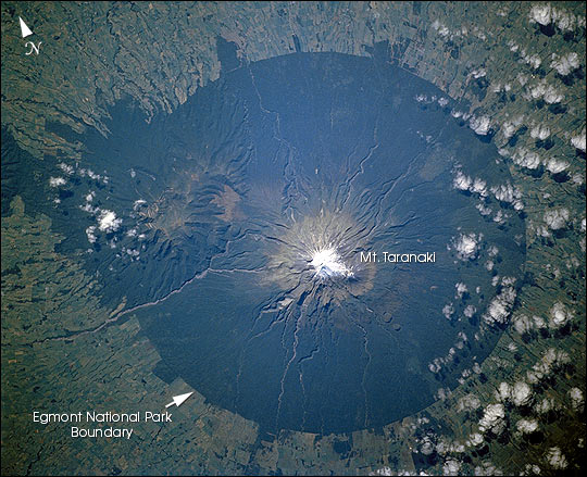
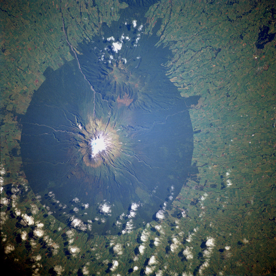
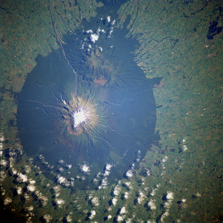
Features: MT. EGMONT (MT. TARANAKI)
Center Point Latitude: -39.5 Center Point Longitude: 174.0 (Negative numbers indicate south for latitude and west for longitude)
Stereo: (Yes indicates there is an adjacent picture of the same area)
ONC Map ID: JNC Map ID:
Camera
Camera Tilt: High ObliqueCamera Focal Length: 110mm
Camera: HB: Hasselblad
Film: 5069 : Kodak Elite 100S, E6 Reversal, Replaces Lumiere, Warmer in tone vs. Lumiere.
Quality
Film Exposure:Percentage of Cloud Cover: 25 (11-25)
Nadir
Date: 20020409 (YYYYMMDD)GMT Time: 225606 (HHMMSS)Nadir Point Latitude: -38.2, Longitude: 175.8 (Negative numbers indicate south for latitude and west for longitude)
Nadir to Photo Center Direction: Southwest
Sun Azimuth: 27 (Clockwise angle in degrees from north to the sun measured at the nadir point)
Spacecraft Altitude: 90 nautical miles (167 km)
Sun Elevation Angle: 40 (Angle in degrees between the horizon and the sun, measured at the nadir point)
Orbit Number: 18
Captions
STS110-726-6 Mount Egmont Volcano, New Zealand April 2002Mount Egmont Volcano (sometimes referred to as Mount Taranaki) is a young stratovolcano that began to form 70 000 years ago. Located in southwest North Island, New Zealand, Mount Egmont, at 8261 feet (2518 meters) is the second tallest volcanic mountain in New Zealand. Perpetually snow-capped, the volcano last erupted in 1755. Mount Egmont has a history of a major size eruption occurring every 340 years, with numerous minor ones in between. The volcano has had three major cone collapses in the last 25 000 years with the last collapse occurring 6970 years ago. With each collapse, thick layers of ash and lava crumbled into thick, muddy avalanches called lahars. These lahars have reached the coastline 25 miles (40 km) to the west and north of the volcano (bottom center and left center). The volcano is surrounded by forest, especially on its lower flanks, which is part of a National Park. The lush forests of Egmont National Park, on New Zealand’s North Island, contrast with the pasturelands outside the circular park boundaries. The unique shape of the park results from its first protection in 1881, which specified that a forest reserve would extend in a 9.6 km radius from the summit of Mt. Taranaki (named Mt. Egmont by Captain Cook). The park covers about 33 500 hectares and Mt. Egmont stands at 2518 m. A series of montane habitats occur in procession up the flanks of the volcano—from rainforest, to shrubs, to alpine, and finally snow cover.
Download Packaged File.
This option downloads the following items, packaged into a single file, if they are available:
- Browse image
- Cataloged information with captions
- Camera file
- Sound file
Server: 2 |
This service is provided by the International Space Station program. |
Recommended Citation: |
||

