| Home >> | Advanced Search >> |
 |
|
Astronaut Photography of Earth - Display Record
ISS009-E-5944

Low-resolution Browse Image
(Most browse images are not color adjusted.)Images
Conditions for Use of Images >>Image Transformation Tutorial >> Saving, Color Adjusting, and Printing Images >>
Images to View on Your Computer Now
| File Name | File Size (bytes) | Width | Height | Annotated | Cropped | Purpose | Comments | |
|---|---|---|---|---|---|---|---|---|
| View | ISS009-E-5944.JPG | 41899 | 538 | 268 | NASA's Earth Observatory web site | |||
| View | ISS009-E-5944.JPG | 42287 | 639 | 435 | No | No | ||
| View | ISS009-E-5944.JPG | 418304 | 662 | 1000 | No | NASA's Earth Observatory web site | color adjusted |
Large Images to Request for Downloading
| File Name | File Size (bytes) | Width | Height | Annotated | Cropped | Purpose | Comments | |
|---|---|---|---|---|---|---|---|---|
| Request | ISS009-E-5944.JPG | 683848 | 3032 | 2064 | No | No |
Download a Keyhole Markup Language (KML) file for use in Google Earth.
Electronic Image Data
Camera Files >> No sound file available.Identification
Mission: ISS009 Roll: E Frame: 5944 Mission ID on the Film or image: ISS009Country or Geographic Name: MEXICO
Features: VOLCANIC CONES, LAVA, DRAINAGE
Center Point Latitude: 31.9 Center Point Longitude: -113.4 (Negative numbers indicate south for latitude and west for longitude)
Stereo: (Yes indicates there is an adjacent picture of the same area)
ONC Map ID: JNC Map ID:
Camera
Camera Tilt: 28Camera Focal Length: 400mm
Camera: E4: Kodak DCS760C Electronic Still Camera
Film: 3060E : 3060 x 2036 pixel CCD, RGBG array.
Quality
Film Exposure:Percentage of Cloud Cover: 10 (0-10)
Nadir
Date: 20040507 (YYYYMMDD)GMT Time: 140324 (HHMMSS)Nadir Point Latitude: 30.9, Longitude: -112.1 (Negative numbers indicate south for latitude and west for longitude)
Nadir to Photo Center Direction: Northwest
Sun Azimuth: 80 (Clockwise angle in degrees from north to the sun measured at the nadir point)
Spacecraft Altitude: 189 nautical miles (350 km)
Sun Elevation Angle: 17 (Angle in degrees between the horizon and the sun, measured at the nadir point)
Orbit Number: 3194
Captions
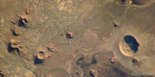
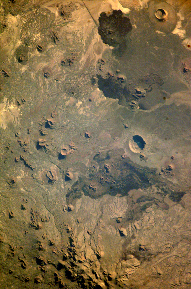
Pinacates Biosphere Reserve:The Pinacates region of Mexico’s Sonoran Desert is one of the most unique and striking landscapes in North America. Located just a few miles south of the Mexico-Arizona border, this volcanic field originated with the rifting of the Gulf of California millions of years ago, but the features seen today (volcanic peaks, lava flows, cinder cones and collapsed craters) formed in the late Pleistocene period (2 million to 11,000 years ago). The volcanic range is surrounded by one of North America’s largest dune fields, Gran Desierto.
The natural history of the region includes thousands of years of human occupation; it is the aboriginal homeland of the O‘Odham tribe, also known as the Papago. The region also served as an early training site for Apollo astronauts in the 1960s. This ecosystem supports a wonderfully diverse northern Sonoran desert assemblage of plants and animals, including large saguaro cacti, ocotillo, many species of reptiles, amphibians, and insects. In fact, the name Pinacate is derived from “pinacatl,” the Aztec name for the desert stink beetle, which is common in the region. The natural and cultural resource management of the region, including the archeological sites and the high biodiversity, is now guaranteed: the site was declared a UNESCO Biosphere Reserve in 1993.
Early in May 2004, the new Space Station crew (ISS-9) obtained high-resolution images of the Pinacates, allowing for detailed observations of the surface features. One example is a large volcanic crater (see box in image ISS009-E-5953, and detail in current image) called Crater Elegante which is one of the most prominent and interesting features of the Pinacates. For scale, the diameter of the crater is approximately 1500 meters. Such detailed images can be used to monitor vegetation and development in the region.
Download Packaged File.
This option downloads the following items, packaged into a single file, if they are available:
- Browse image
- Cataloged information with captions
- Camera file
- Sound file
Server: 2 |
This service is provided by the International Space Station program. |
Recommended Citation: |
||

