| Home >> | Advanced Search >> |
 |
|
Astronaut Photography of Earth - Display Record
ISS007-E-5697

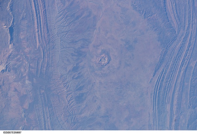
Low-resolution Browse Image
(Most browse images are not color adjusted.)Images
Conditions for Use of Images >>Image Transformation Tutorial >> Saving, Color Adjusting, and Printing Images >>
Images to View on Your Computer Now
| File Name | File Size (bytes) | Width | Height | Annotated | Cropped | Purpose | Comments | |
|---|---|---|---|---|---|---|---|---|
| View | ISS007-E-5697.JPG | 56978 | 540 | 405 | Yes | Yes | NASA's Earth Observatory web site | |
| View | ISS007-E-5697.JPG | 56978 | 540 | 405 | Yes | Yes | NASA's Earth Observatory web site | Color adjusted |
| View | ISS007-E-5697.JPG | 80363 | 639 | 435 | No | No | ||
| View | ISS007-E-5697.JPG | 84651 | 540 | 352 | Photographic Highlights | (resized 540 px images) | ||
| View | ISS007-E-5697.JPG | 1064537 | 1000 | 651 | Yes |
Large Images to Request for Downloading
| File Name | File Size (bytes) | Width | Height | Annotated | Cropped | Purpose | Comments | |
|---|---|---|---|---|---|---|---|---|
| Request | ISS007-E-5697.JPG | 325963 | 1000 | 651 | Photographic Highlights | (actual files used) | ||
| Request | ISS007-E-5697.JPG | 1180705 | 3032 | 2064 | No | No | NASA's Earth Observatory web site | |
| Request | ISS007-E-5697_2.JPG | 5589899 | 6144 | 4068 | No | No | Presentation | Earth Sciences Results Briefing/Ed Lu |
Download a Keyhole Markup Language (KML) file for use in Google Earth.
Electronic Image Data
Camera Files >> No sound file available.Identification
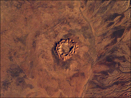
Mission: ISS007 Roll: E Frame: 5697 Mission ID on the Film or image: ISS007Country or Geographic Name: AUSTRALIA-NT
Features: GOSSES BLUFF IMPACT CRATER
Center Point Latitude: -24.0 Center Point Longitude: 132.5 (Negative numbers indicate south for latitude and west for longitude)
Stereo: (Yes indicates there is an adjacent picture of the same area)
ONC Map ID: JNC Map ID:
Camera
Camera Tilt: 30Camera Focal Length: 180mm
Camera: E4: Kodak DCS760C Electronic Still Camera
Film: 3060E : 3060 x 2036 pixel CCD, RGBG array.
Quality
Film Exposure:Percentage of Cloud Cover: 10 (0-10)
Nadir
Date: 20030520 (YYYYMMDD)GMT Time: 225637 (HHMMSS)Nadir Point Latitude: -22.8, Longitude: 134.1 (Negative numbers indicate south for latitude and west for longitude)
Nadir to Photo Center Direction: Southwest
Sun Azimuth: 59 (Clockwise angle in degrees from north to the sun measured at the nadir point)
Spacecraft Altitude: 211 nautical miles (391 km)
Sun Elevation Angle: 17 (Angle in degrees between the horizon and the sun, measured at the nadir point)
Orbit Number: 1675
Captions
Impact craters, like those we observe on the moon, also occur on Earth. They result from the collisions of extraterrestrial bodies (like meteorites, asteroids or comets) with the Earth. Planetary scientists study Earth’s impact craters to gain insight about the early history of the Earth and the Solar System. Recent studies indicate that large impacts on Earth may have played an important role in the succession of life on Earth.Australia is a very good place to observe and study impact craters. Much of the Australian surface is very old, so Australia has collected more impacts than many other parts of the world. Because of the dry climate, the craters haven’t weathered away, nor are they hidden by dense vegetation.
This image shows Gosses Bluff, an impact crater sandwiched between the Macdonnell Range to the north and the James Range to the south in Australia’s Northern Territory—it is about 160 km west of Alice Springs. It is one of the most studied of the Australian impact craters. The impactor, an asteroid or comet, was probably about 1 km in diameter and crashed into the earth about 142 million years ago. The isolated circular feature within the crater consists of a central ring of hills about 4.5 km in diameter. The grayish feature surrounding the inner ring probably marks the original boundary of the outer rim.
Download Packaged File.
This option downloads the following items, packaged into a single file, if they are available:
- Browse image
- Cataloged information with captions
- Camera file
- Sound file
Server: 2 |
This service is provided by the International Space Station program. |
Recommended Citation: |
||

