| Home >> | Advanced Search >> |
 |
|
Astronaut Photography of Earth - Display Record
ISS015-E-5624
Low-resolution Browse Image
(Most browse images are not color adjusted.)Images
Conditions for Use of Images >>Image Transformation Tutorial >> Saving, Color Adjusting, and Printing Images >>
Images to View on Your Computer Now
| File Name | File Size (bytes) | Width | Height | Annotated | Cropped | Purpose | Comments | |
|---|---|---|---|---|---|---|---|---|
| View | ISS015-E-5624.JPG | 102195 | 639 | 435 | No | No | ||
| View | ISS015-E-5624.JPG | 663587 | 540 | 790 | Yes | Yes | NASA's Earth Observatory web site |
Large Images to Request for Downloading
| File Name | File Size (bytes) | Width | Height | Annotated | Cropped | Purpose | Comments | |
|---|---|---|---|---|---|---|---|---|
| Request | ISS015-E-5624.JPG | 1557355 | 3032 | 2064 | No | No | ||
| Request | ISS015-E-5624.JPG | 2022019 | 1000 | 1487 | No | Yes | NASA's Earth Observatory web site |
Download a Keyhole Markup Language (KML) file for use in Google Earth.
Electronic Image Data
Camera Files >> No sound file available.Identification
Mission: ISS015 Roll: E Frame: 5624 Mission ID on the Film or image: ISS015Country or Geographic Name: USA-NEW YORK
Features: BUFFALO,NIAGARA FALLS
Center Point Latitude: 43.1 Center Point Longitude: -79.0 (Negative numbers indicate south for latitude and west for longitude)
Stereo: (Yes indicates there is an adjacent picture of the same area)
ONC Map ID: JNC Map ID:
Camera
Camera Tilt: High ObliqueCamera Focal Length: 180mm
Camera: E4: Kodak DCS760C Electronic Still Camera
Film: 3060E : 3060 x 2036 pixel CCD, RGBG array.
Quality
Film Exposure:Percentage of Cloud Cover: 10 (0-10)
Nadir
Date: 20070429 (YYYYMMDD)GMT Time: 174112 (HHMMSS)Nadir Point Latitude: 46.8, Longitude: -71.5 (Negative numbers indicate south for latitude and west for longitude)
Nadir to Photo Center Direction: West
Sun Azimuth: 205 (Clockwise angle in degrees from north to the sun measured at the nadir point)
Spacecraft Altitude: 173 nautical miles (320 km)
Sun Elevation Angle: 56 (Angle in degrees between the horizon and the sun, measured at the nadir point)
Orbit Number: 312
Captions
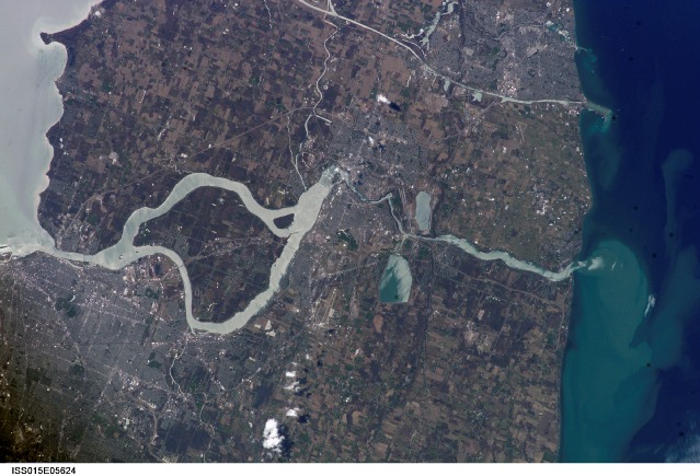
Springtime Comes to the Niagara River:(image is paired with/compared to image ISS014-E-17999)
What a difference a month makes! These two images of the Niagara River draining Lake Erie (bottom) into Lake Ontario (top) were acquired about a month apart (March 21 and April 29, 2007, respectively) from the International Space Station. The pair documents the breakup of the Lake Erie ice pack, the unofficial signature of spring for residents of Buffalo and Niagara Falls. In March, the eastern end of Lake Erie is clogged with ice that is pushed against the shoreline by the prevailing westerly wind. The ice collects in Lake Erie, and the Lake Erie-Niagara River Ice Boom prevents it from flowing down the Niagara River, which is the international boundary between the Canadian Province of Ontario, and New York State.
The 2,680-meter (8,800-foot) boom is deployed each December. Operational since 1964, the boom serves several functions: it protects the water intakes for the Niagara River power plants, and it minimizes ice runs (large blocks of ice flowing downstream as ice breaks up in the spring) and blockages that can create damage and flooding along the river. At the height of winter, the thickness of the ice at the Buffalo harbor can reach 3.5 meters (12 feet). The removal of the ice boom, usually in early April, is now marked by local celebrations. This year the boom was removed in mid-April, a bit later than usual. A webcam allows remote viewers to monitor ice pack at the boom.
During their missions, astronauts track the changing seasons using such indicators as the springtime melting of ice packs in high-latitude oceans and lakes. Over the next two years, the space station astronauts will make these types of observations to support International Polar Year (IPY) investigations. Scientists interested in requesting high-latitude imagery from the space station for IPY science should visit the Johnson Space Center Gateway to Astronaut Photography of the Earth International Polar Year Website.
Download Packaged File.
This option downloads the following items, packaged into a single file, if they are available:
- Browse image
- Cataloged information with captions
- Camera file
- Sound file
Server: 2 |
This service is provided by the International Space Station program. |
Recommended Citation: |
||

