| Home >> | Advanced Search >> |
 |
|
Astronaut Photography of Earth - Display Record
ISS005-E-5419
Low-resolution Browse Image
(Most browse images are not color adjusted.)Images
Conditions for Use of Images >>Image Transformation Tutorial >> Saving, Color Adjusting, and Printing Images >>
Images to View on Your Computer Now
| File Name | File Size (bytes) | Width | Height | Annotated | Cropped | Purpose | Comments | |
|---|---|---|---|---|---|---|---|---|
| View | ISS005-E-5419.JPG | 48793 | 540 | 357 | Yes | Yes | NASA's Earth Observatory web site | |
| View | ISS005-E-5419.JPG | 77996 | 639 | 435 | No | No | From STIC, color adjusted | |
| View | ISS005-E-5419.JPG | 241639 | 354 | 540 | Photographic Highlights | (540 px resized images) | ||
| View | ISS005-E-5419_2.JPG | 490629 | 504 | 768 | Photographic Highlights | (actual files used) | ||
| View | ISS005-E-5419.JPG | 561405 | 1024 | 676 | No | No | NASA's Earth Observatory web site |
Large Images to Request for Downloading
| File Name | File Size (bytes) | Width | Height | Annotated | Cropped | Purpose | Comments | |
|---|---|---|---|---|---|---|---|---|
| Request | ISS005-E-5419.JPG | 1255021 | 3032 | 2064 | No | No | From STIC, color adjusted |
Download a Keyhole Markup Language (KML) file for use in Google Earth.
Electronic Image Data
Camera Files >> No sound file available.Identification
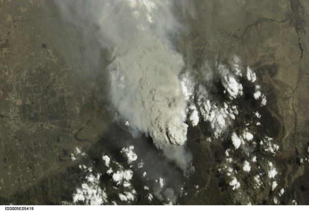
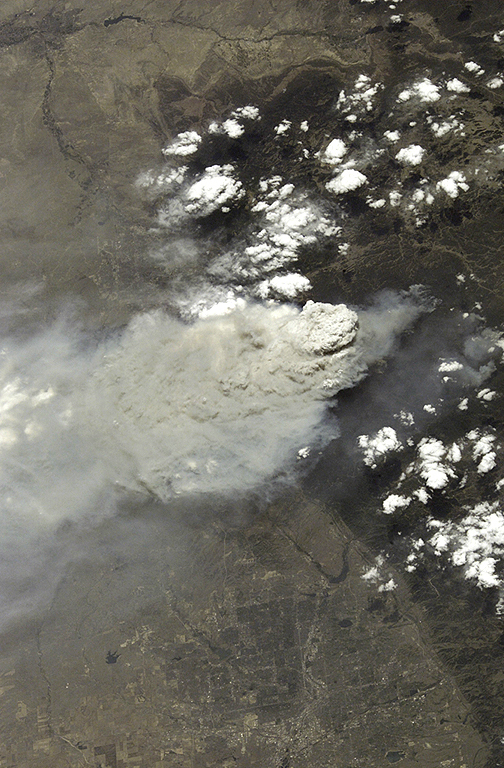
Mission: ISS005 Roll: E Frame: 5419 Mission ID on the Film or image: ISS005Country or Geographic Name: USA-COLORADO
Features: HAYMAN FIRE NEAR DENVER
Center Point Latitude: 39.5 Center Point Longitude: -105.0 (Negative numbers indicate south for latitude and west for longitude)
Stereo: (Yes indicates there is an adjacent picture of the same area)
ONC Map ID: JNC Map ID:
Camera
Camera Tilt: 40Camera Focal Length: 130mm
Camera: E4: Kodak DCS760C Electronic Still Camera
Film: 3060E : 3060 x 2036 pixel CCD, RGBG array.
Quality
Film Exposure:Percentage of Cloud Cover: 10 (0-10)
Nadir
Date: 20020618 (YYYYMMDD)GMT Time: 191859 (HHMMSS)Nadir Point Latitude: 42.2, Longitude: -106.3 (Negative numbers indicate south for latitude and west for longitude)
Nadir to Photo Center Direction: South
Sun Azimuth: 189 (Clockwise angle in degrees from north to the sun measured at the nadir point)
Spacecraft Altitude: 212 nautical miles (393 km)
Sun Elevation Angle: 71 (Angle in degrees between the horizon and the sun, measured at the nadir point)
Orbit Number: 432
Captions
Hayman Fire and Others Scorch Western U.S.This photograph taken by the new International Space Station crew on June 18, 2002, shows the Hayman Fire burning in the foothills southwest of Denver. Astronauts use a variety of lenses and look angles as their orbits pass over wildfires to document the long-distance movements of smoke from the fires as well as details of the burning areas. In this perspective view, you can see Littleton, Chatfield Lake and the Arkansas River.
Download Packaged File.
This option downloads the following items, packaged into a single file, if they are available:
- Browse image
- Cataloged information with captions
- Camera file
- Sound file
Server: 2 |
This service is provided by the International Space Station program. |
Recommended Citation: |
||

