| Home >> | Advanced Search >> |
 |
|
Astronaut Photography of Earth - Display Record
ISS007-E-5366

Low-resolution Browse Image
(Most browse images are not color adjusted.)Images
Conditions for Use of Images >>Image Transformation Tutorial >> Saving, Color Adjusting, and Printing Images >>
Images to View on Your Computer Now
| File Name | File Size (bytes) | Width | Height | Annotated | Cropped | Purpose | Comments | |
|---|---|---|---|---|---|---|---|---|
| View | ISS007-E-5366.JPG | 32690 | 540 | 335 | Photographic Highlights | (resized 540 px images) | ||
| View | ISS007-E-5366.JPG | 56664 | 639 | 435 | No | No | ||
| View | ISS007-E-5366.JPG | 105464 | 540 | 402 | Yes | NASA's Earth Observatory web site | Color adjusted | |
| View | ISS007-E-5366.JPG | 105464 | 540 | 402 | Yes | Yes | NASA's Earth Observatory web site | |
| View | ISS007-E-5366_2.JPG | 123616 | 998 | 619 | Photographic Highlights | (actual files used) | ||
| View | ISS007-E-5366.JPG | 707697 | 1000 | 621 | No | No | NASA's Earth Observatory web site |
Large Images to Request for Downloading
| File Name | File Size (bytes) | Width | Height | Annotated | Cropped | Purpose | Comments | |
|---|---|---|---|---|---|---|---|---|
| Request | ISS007-E-5366.JPG | 1051855 | 3032 | 2064 | No | No | ||
| Request | ISS007-E-5366_2.JPG | 4410986 | 6144 | 4068 | No | No | Presentation | Earth Sciences Results Briefing/Ed Lu |
Download a Keyhole Markup Language (KML) file for use in Google Earth.
Electronic Image Data
Camera Files >> No sound file available.Identification
Mission: ISS007 Roll: E Frame: 5366 Mission ID on the Film or image: ISS007Country or Geographic Name: NORTHERN MARIANA IS.
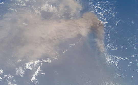
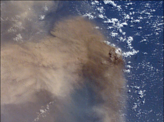
Features: VOLCANIC ERUPTION ON ANATAHAN
Center Point Latitude: 16.5 Center Point Longitude: 145.5 (Negative numbers indicate south for latitude and west for longitude)
Stereo: (Yes indicates there is an adjacent picture of the same area)
ONC Map ID: JNC Map ID:
Camera
Camera Tilt: 49Camera Focal Length: 50mm
Camera: E4: Kodak DCS760C Electronic Still Camera
Film: 3060E : 3060 x 2036 pixel CCD, RGBG array.
Quality
Film Exposure:Percentage of Cloud Cover: 25 (11-25)
Nadir
Date: 20030511 (YYYYMMDD)GMT Time: 001928 (HHMMSS)Nadir Point Latitude: 14.8, Longitude: 141.8 (Negative numbers indicate south for latitude and west for longitude)
Nadir to Photo Center Direction: East
Sun Azimuth: 80 (Clockwise angle in degrees from north to the sun measured at the nadir point)
Spacecraft Altitude: 209 nautical miles (387 km)
Sun Elevation Angle: 59 (Angle in degrees between the horizon and the sun, measured at the nadir point)
Orbit Number: 1520
Captions
It is sleep time on the International Space Station, and astronaut Ed Lu is supposed to be asleep. He is looking out the window and admiring the Pacific Ocean below. Suddenly he realizes something is strange. A huge yellowish-brown plume is sweeping across hundreds of miles of ocean. A major volcanic eruption is in progress—he grabs a camera and shoots.Space Station crewmembers receive a daily list of photographic targets that include areas of scientific interest and dynamic events. In this case, though, the crew observed the eruption before news had spread to the international media or to the networks that track volcanic events worldwide. Ed checked with NASA Cap Com to find out whether it really was a volcano and precisely where the eruption was occurring.
The eruption was from the volcano on Anatahan Island, which is located 80 miles north of Saipan and is part of the Northern Mariana Island Chain. This small island, 6 miles long by 2 miles wide, has been uninhabited since 1990 when residents were evacuated because of a strong earthquake. The lower photograph shows how Anatahan looked from the Space Shuttle in 1996 (photo STS080-708-28).
On the night of May 10, the Anatahan Volcano announced itself with a vigorous eruption that sent high-level ash over a wide area. About 12 hours later, on May 11 at 00:19 GMT, the crew of the International Space Station observed and photographed this ash plume, describing it as huge. By May 15 a state of emergency had been declared in the Northern Mariana Islands as the eruption appeared to be intensifying.
Download Packaged File.
This option downloads the following items, packaged into a single file, if they are available:
- Browse image
- Cataloged information with captions
- Camera file
- Sound file
Server: 2 |
This service is provided by the International Space Station program. |
Recommended Citation: |
||

