| Home >> | Advanced Search >> |
 |
|
Astronaut Photography of Earth - Display Record
STS111-E-5224

Low-resolution Browse Image
(Most browse images are not color adjusted.)Images
Conditions for Use of Images >>Image Transformation Tutorial >> Saving, Color Adjusting, and Printing Images >>
Images to View on Your Computer Now
| File Name | File Size (bytes) | Width | Height | Annotated | Cropped | Purpose | Comments | |
|---|---|---|---|---|---|---|---|---|
| View | STS111-E-5224.JPG | 94990 | 639 | 435 | No | No | ||
| View | STS111-E-5224.JPG | 110436 | 540 | 908 | Yes | Yes | NASA's Earth Observatory web site | |
| View | STS111-E-5224.JPG | 232662 | 540 | 405 | Photographic Highlights | (540px resized images) | ||
| View | STS111-E-5224.JPG | 298653 | 1000 | 1571 | No | Yes | NASA's Earth Observatory web site |
Large Images to Request for Downloading
| File Name | File Size (bytes) | Width | Height | Annotated | Cropped | Purpose | Comments | |
|---|---|---|---|---|---|---|---|---|
| Request | STS111-E-5224.JPG | 361767 | 1024 | 768 | Photographic Highlights | (actual files used) | ||
| Request | STS111-E-5224.JPG | 1537756 | 3032 | 2064 | No | No |
Download a Keyhole Markup Language (KML) file for use in Google Earth.
Electronic Image Data
Camera Files >> No sound file available.Identification
Mission: STS111 Roll: E Frame: 5224 Mission ID on the Film or image: STS111Country or Geographic Name: USA-CALIFORNIA
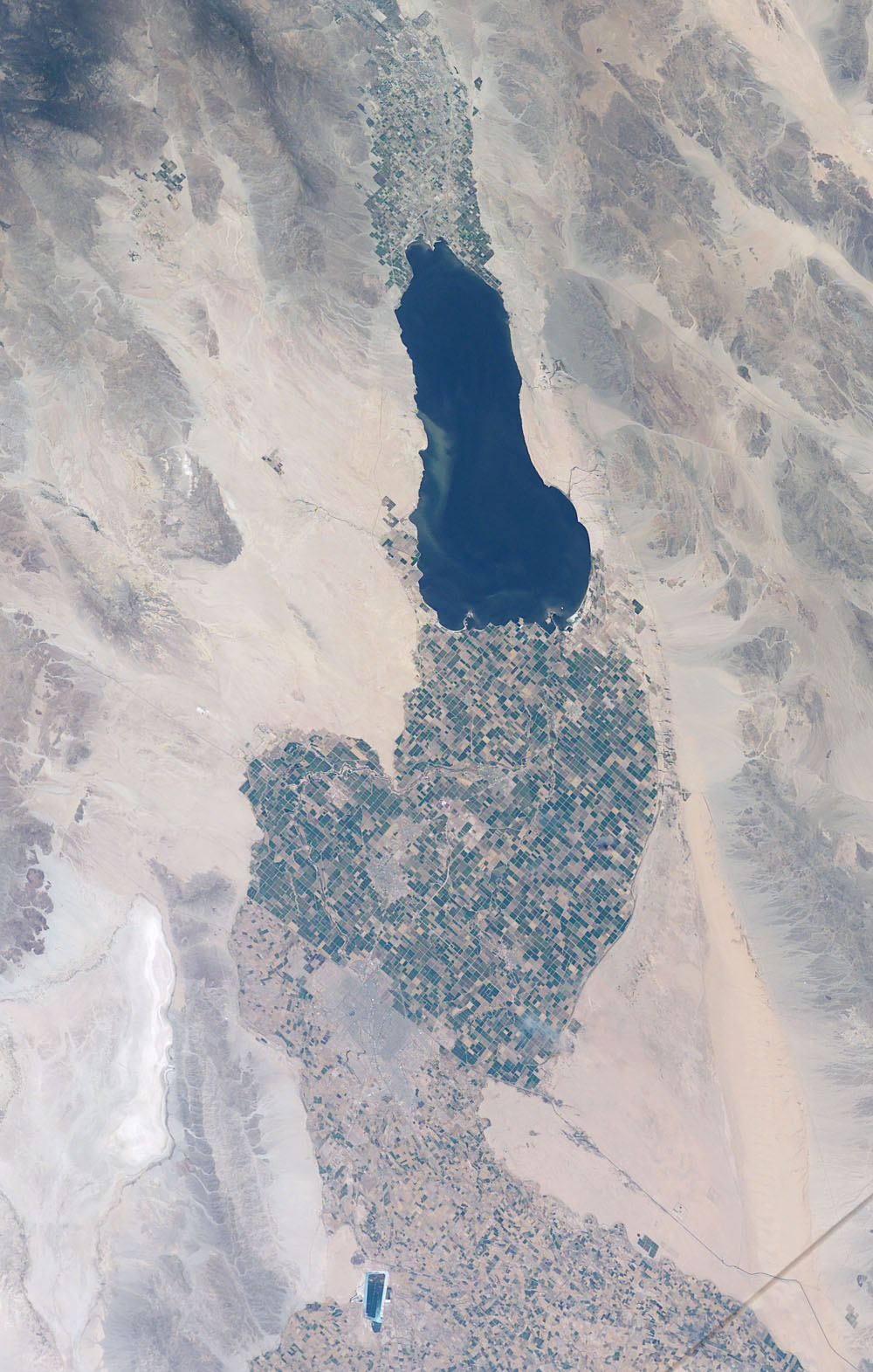
Features: SALTON SEA, IMPERIAL VALLEY
Center Point Latitude: 33.5 Center Point Longitude: -116.0 (Negative numbers indicate south for latitude and west for longitude)
Stereo: (Yes indicates there is an adjacent picture of the same area)
ONC Map ID: JNC Map ID:
Camera
Camera Tilt:Camera Focal Length: 70mm
Camera: E4: Kodak DCS760C Electronic Still Camera
Film: 3060E : 3060 x 2036 pixel CCD, RGBG array.
Quality
Film Exposure:Percentage of Cloud Cover: 10 (0-10)
Nadir
Date: 20020612 (YYYYMMDD)GMT Time: (HHMMSS)Nadir Point Latitude: , Longitude: (Negative numbers indicate south for latitude and west for longitude)
Nadir to Photo Center Direction:
Sun Azimuth: (Clockwise angle in degrees from north to the sun measured at the nadir point)
Spacecraft Altitude: nautical miles (0 km)
Sun Elevation Angle: (Angle in degrees between the horizon and the sun, measured at the nadir point)
Orbit Number:
Captions
Southern California’s Salton Sea is a prominent visual for astronauts. This large lake supports the rich agricultural fields of the Imperial, Coachella and Mexicali Valleys in the California and Mexico desert. The Salton Sea formed by accident in 1905 when an irrigation canal ruptured, allowing the Colorado River to flood the Salton Basin. Today the Sea performs an important function as the sink for agricultural runoff; water levels are maintained by the runoff from the surrounding agricultural valleys. The Salton Sea salinity is high—nearly 1/4 saltier than ocean water—but it remains an important stopover point for migratory water birds, including several endangered species.The region also experiences several environmental problems. The recent increased demands for the limited Colorado River water threatens the amount of water allowed to flow into the Salton Sea. Increased salinity and decreased water levels could trigger several regional environmental crises.
The agricultural flow into the Sea includes nutrients and agricultural by-products, increasing the productivity and likelihood of algae blooms. This image shows either a bloom, or suspended sediment (usually highly organic) in the water that has been stirred up by winds.
Additional information: Land Use Across the U.S.-Mexico Border.
Download Packaged File.
This option downloads the following items, packaged into a single file, if they are available:
- Browse image
- Cataloged information with captions
- Camera file
- Sound file
Server: 2 |
This service is provided by the International Space Station program. |
Recommended Citation: |
||

