| Home >> | Advanced Search >> |
 |
|
Astronaut Photography of Earth - Display Record
ISS010-E-5194

Low-resolution Browse Image
(Most browse images are not color adjusted.)Images
Conditions for Use of Images >>Image Transformation Tutorial >> Saving, Color Adjusting, and Printing Images >>
Images to View on Your Computer Now
| File Name | File Size (bytes) | Width | Height | Annotated | Cropped | Purpose | Comments | |
|---|---|---|---|---|---|---|---|---|
| View | ISS010-E-5194.JPG | 85448 | 639 | 435 | No | No | ||
| View | ISS010-E-5194.JPG | 256514 | 540 | 339 | Yes | Yes | Earth From Space collection | |
| View | ISS010-E-5194.JPG | 770053 | 1000 | 628 | No | Yes | NASA's Earth Observatory web site |
Large Images to Request for Downloading
| File Name | File Size (bytes) | Width | Height | Annotated | Cropped | Purpose | Comments | |
|---|---|---|---|---|---|---|---|---|
| Request | ISS010-E-5194.JPG | 1106533 | 3032 | 2064 | No | No |
Download a Keyhole Markup Language (KML) file for use in Google Earth.
Electronic Image Data
Camera Files >> No sound file available.Identification
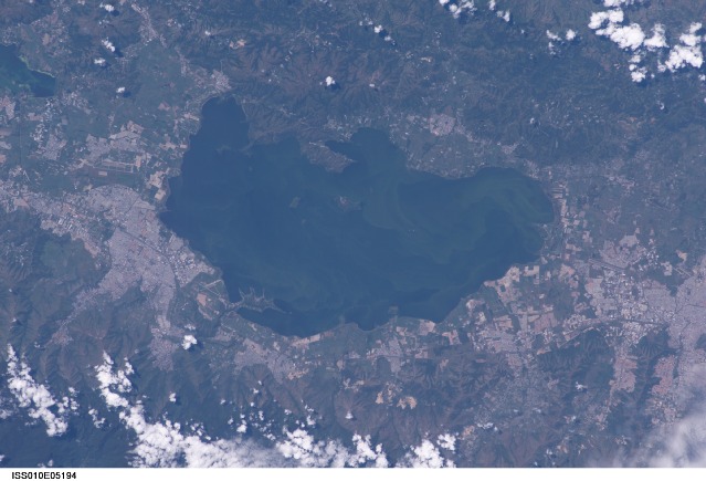
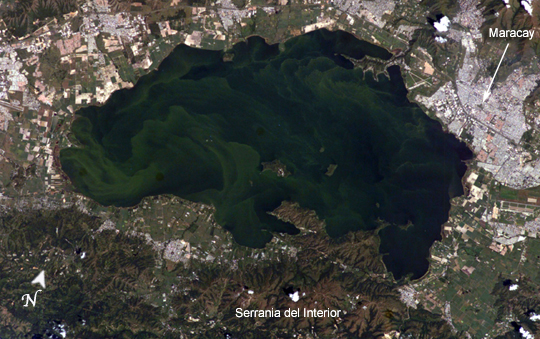
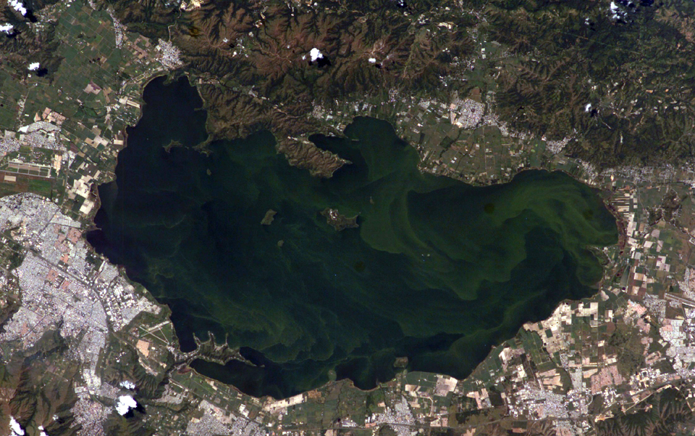
Mission: ISS010 Roll: E Frame: 5194 Mission ID on the Film or image: ISS010Country or Geographic Name: VENEZUELA
Features: L. VALENCIA, MARACAY, MTS.
Center Point Latitude: 10.0 Center Point Longitude: -67.5 (Negative numbers indicate south for latitude and west for longitude)
Stereo: (Yes indicates there is an adjacent picture of the same area)
ONC Map ID: JNC Map ID:
Camera
Camera Tilt: 22Camera Focal Length: 180mm
Camera: E4: Kodak DCS760C Electronic Still Camera
Film: 3060E : 3060 x 2036 pixel CCD, RGBG array.
Quality
Film Exposure:Percentage of Cloud Cover: 10 (0-10)
Nadir
Date: 20041027 (YYYYMMDD)GMT Time: 141506 (HHMMSS)Nadir Point Latitude: 8.8, Longitude: -66.9 (Negative numbers indicate south for latitude and west for longitude)
Nadir to Photo Center Direction: North
Sun Azimuth: 127 (Clockwise angle in degrees from north to the sun measured at the nadir point)
Spacecraft Altitude: 195 nautical miles (361 km)
Sun Elevation Angle: 54 (Angle in degrees between the horizon and the sun, measured at the nadir point)
Orbit Number: 1911
Captions
Lago de Valencia (Lake Valencia) is located in north-central Venezuela and is the largest freshwater lake in the country. The lake was formed approximately 2-3 million years ago due to faulting and subsequent damming of the Valencia River. The lake has been completely dry during several discrete periods of its geologic history. Since 1976 Lake Valencia water levels have risen due to diversion of water from neighboring watersheds—it currently acts as a reservoir for the surrounding urban centers (such as Maracay).The vivid green algal blooms present in this image result from a continual influx of untreated wastewater from the surrounding urban, agricultural, and industrial land uses. This contributes to ongoing eutrophication, contamination, and salinization of the lake. Despite its picturesque location between the Cordillera de la Costa to the north and the Serrania del Interior to the south, Lake Valencia’s poor water quality limits opportunities for tourism and recreational activities.
Download Packaged File.
This option downloads the following items, packaged into a single file, if they are available:
- Browse image
- Cataloged information with captions
- Camera file
- Sound file
Server: 2 |
This service is provided by the International Space Station program. |
Recommended Citation: |
||

