| Home >> | Advanced Search >> |
 |
|
Astronaut Photography of Earth - Display Record
GEM05-1-45778

Low-resolution Browse Image
(Most browse images are not color adjusted.)Images
Conditions for Use of Images >>Image Transformation Tutorial >> Saving, Color Adjusting, and Printing Images >>
Images to View on Your Computer Now
| File Name | File Size (bytes) | Width | Height | Annotated | Cropped | Purpose | Comments | |
|---|---|---|---|---|---|---|---|---|
| View | GEM05-1-45778.JPG | 142731 | 540 | 424 | Yes | Yes | NASA's Earth Observatory web site | |
| View | GEM05-1-45778.JPG | 219580 | 1054 | 842 | NASA's Earth Observatory web site | |||
| View | GEM05-1-45778_2.JPG | 68163 | 400 | 315 | No | Photographic Highlights |
Large Images to Request for Downloading
| File Name | File Size (bytes) | Width | Height | Annotated | Cropped | Purpose | Comments | |
|---|---|---|---|---|---|---|---|---|
| Request | GEM05-1-45778.JPG | 219580 | 1054 | 842 | No | NASA's Earth Observatory web site | ||
| Request | GEM05-1-45778.TIF | 9495468 | 2592 | 2572 | No | No |
Download a Keyhole Markup Language (KML) file for use in Google Earth.
Electronic Image Data
Camera files only apply to electronic still cameras.No sound file available.
Identification
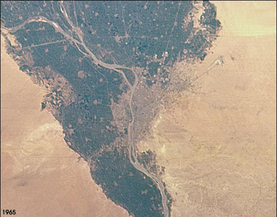
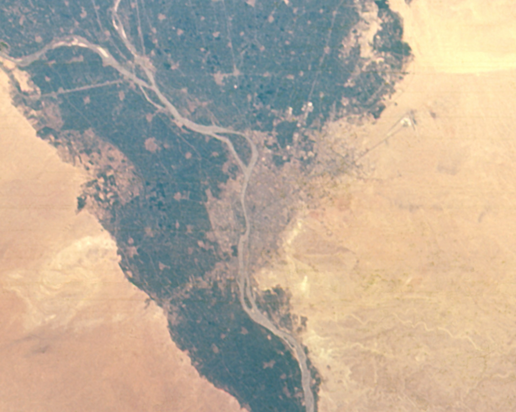
Mission: GEM05 Roll: 1 Frame: 45778 Mission ID on the Film or image: GT-5Country or Geographic Name: EGYPT
Features: CAIRO, NILE RIVER
Center Point Latitude: 30.5 Center Point Longitude: 31.5 (Negative numbers indicate south for latitude and west for longitude)
Stereo: No (Yes indicates there is an adjacent picture of the same area)
ONC Map ID: JNC Map ID:
Camera
Camera Tilt:Camera Focal Length: 80mm
Camera: HB: Hasselblad
Film: SO217 : Kodak Ektachrome with haze filter.
Quality
Film Exposure: NormalPercentage of Cloud Cover: 0 (0-10)
Nadir
Date: 196508__ (YYYYMMDD)GMT Time: (HHMMSS)Nadir Point Latitude: , Longitude: (Negative numbers indicate south for latitude and west for longitude)
Nadir to Photo Center Direction:
Sun Azimuth: (Clockwise angle in degrees from north to the sun measured at the nadir point)
Spacecraft Altitude: nautical miles (0 km)
Sun Elevation Angle: (Angle in degrees between the horizon and the sun, measured at the nadir point)
Orbit Number:
Captions
The population of the Cairo metropolitan area has increased from less than 6 million in 1965 when this picture was taken, to more than 10 million in 1998 (United Nations Population Division, World Urbanization Prospects, the 1999 revision). Population densities within the city are some of the highest in the world and the urban area has doubled to more than 400 square km during that period. Extraordinary rates of population growth are expected to continue, with a predicted population of around 14 million by 2015. Photographs of Earth taken from early space missions represent some of the earliest data on the state of the world's major cities.Link to Earth Observatory Caption >>
Download Packaged File.
This option downloads the following items, packaged into a single file, if they are available:
- Browse image
- Cataloged information with captions
- Camera file
- Sound file
Server: 2 |
This service is provided by the International Space Station program. |
Recommended Citation: |
||

