| Home >> | Advanced Search >> |
 |
|
Astronaut Photography of Earth - Display Record
ISS006-E-36913

Low-resolution Browse Image
(Most browse images are not color adjusted.)Images
Conditions for Use of Images >>Image Transformation Tutorial >> Saving, Color Adjusting, and Printing Images >>
Images to View on Your Computer Now
| File Name | File Size (bytes) | Width | Height | Annotated | Cropped | Purpose | Comments | |
|---|---|---|---|---|---|---|---|---|
| View | ISS006-E-36913.JPG | 47524 | 540 | 380 | Photographic Highlights | (540 px resized images) | ||
| View | ISS006-E-36913.JPG | 92567 | 540 | 540 | Yes | Yes | NASA's Earth Observatory web site | Color adjusted |
| View | ISS006-E-36913.JPG | 92567 | 540 | 540 | Yes | Yes | NASA's Earth Observatory web site | |
| View | ISS006-E-36913.JPG | 92589 | 639 | 435 | No | No | ||
| View | ISS006-E-36913.JPG | 461257 | 1000 | 1000 | No | No | NASA's Earth Observatory web site |
Large Images to Request for Downloading
| File Name | File Size (bytes) | Width | Height | Annotated | Cropped | Purpose | Comments | |
|---|---|---|---|---|---|---|---|---|
| Request | ISS006-E-36913.JPG | 195114 | 1024 | 720 | Photographic Highlights | (actual files used) | ||
| Request | ISS006-E-36913.JPG | 2299783 | 3032 | 2064 | No | No |
Download a Keyhole Markup Language (KML) file for use in Google Earth.
Electronic Image Data
Camera Files >> No sound file available.Identification
Mission: ISS006 Roll: E Frame: 36913 Mission ID on the Film or image: ISS006Country or Geographic Name: USA-CALIFORNIA
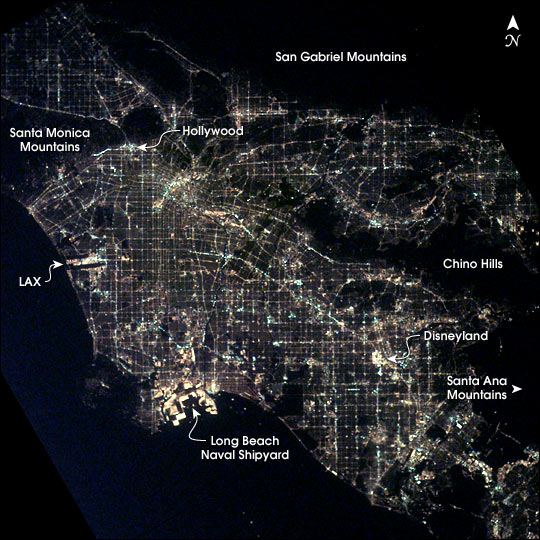
Features: LOS ANGELES AT NIGHT
Center Point Latitude: 34.0 Center Point Longitude: -118.0 (Negative numbers indicate south for latitude and west for longitude)
Stereo: (Yes indicates there is an adjacent picture of the same area)
ONC Map ID: JNC Map ID:
Camera
Camera Tilt: 33Camera Focal Length: 85mm
Camera: E4: Kodak DCS760C Electronic Still Camera
Film: 3060E : 3060 x 2036 pixel CCD, RGBG array.
Quality
Film Exposure:Percentage of Cloud Cover: 10 (0-10)
Nadir
Date: 20030310 (YYYYMMDD)GMT Time: 091507 (HHMMSS)Nadir Point Latitude: 35.3, Longitude: -116.1 (Negative numbers indicate south for latitude and west for longitude)
Nadir to Photo Center Direction: Southwest
Sun Azimuth: 36 (Clockwise angle in degrees from north to the sun measured at the nadir point)
Spacecraft Altitude: 209 nautical miles (387 km)
Sun Elevation Angle: -54 (Angle in degrees between the horizon and the sun, measured at the nadir point)
Orbit Number: 559
Captions
After sunset the borders of “The City of Angels” are defined as much by its dark terrain features as by its well-lit grid of streets and freeways. Over 13 million people inhabit the coastal basin bounded roughly by the Santa Monica and San Gabriel Mountains to the north and the Chino Hills and Santa Ana Mountains to the east and southeast.The crew of the International Space Station took this unique image shortly after 1 a.m. local time on March 10, 2003. Both the glitter and sprawl of America’s second largest city as well as a number of its renowned landmarks are highly visible. In the north, Hollywood is nestled against the south side of the Santa Monica Mountains. On the coast, Los Angeles International Airport (LAX) and the port facilities at Long Beach Naval Shipyards are bright spots. Finally, even at this time of night, the bright lights of Disneyland in Anaheim are a standout feature.
Download Packaged File.
This option downloads the following items, packaged into a single file, if they are available:
- Browse image
- Cataloged information with captions
- Camera file
- Sound file
Server: 2 |
This service is provided by the International Space Station program. |
Recommended Citation: |
||

