| Home >> | Advanced Search >> |
 |
|
Astronaut Photography of Earth - Display Record
STS098-712-29

Low-resolution Browse Image
(Most browse images are not color adjusted.)Images
Conditions for Use of Images >>Image Transformation Tutorial >> Saving, Color Adjusting, and Printing Images >>
Images to View on Your Computer Now
| File Name | File Size (bytes) | Width | Height | Annotated | Cropped | Purpose | Comments | |
|---|---|---|---|---|---|---|---|---|
| View | STS098-712-29.JPG | 16513 | 515 | 512 | No | No | From ISD PhotoCDs | |
| View | STS098-712-29.JPG | 38654 | 540 | 532 | Yes | Yes | NASA's Earth Observatory web site | |
| View | STS098-712-29_2.JPG | 26418 | 400 | 398 | No | No | Photographic Highlights |
Large Images to Request for Downloading
| File Name | File Size (bytes) | Width | Height | Annotated | Cropped | Purpose | Comments | |
|---|---|---|---|---|---|---|---|---|
| Request | STS098-712-29.JPG | 58732 | 1031 | 1024 | No | No | From ISD PhotoCDs | |
| Request | STS098-712-29_2.JPG | 266396 | 2063 | 2048 | No | No | From ISD PhotoCDs | |
| Request | STS098-712-29_3.JPG | 965573 | 4127 | 4096 | No | No | From ISD PhotoCDs | |
| Request | STS098-712-29.TIF | 5023302 | 1297 | 1290 | No | No |
Download a Keyhole Markup Language (KML) file for use in Google Earth.
Electronic Image Data
Camera files only apply to electronic still cameras.No sound file available.
Identification
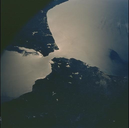
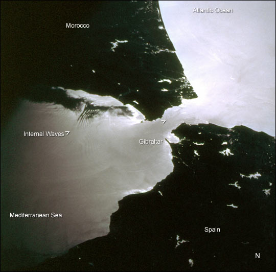
Mission: STS098 Roll: 712 Frame: 29 Mission ID on the Film or image: STS98Country or Geographic Name: SPAIN
Features: STRAIT OF GIBRALTAR, SUNGLINT
Center Point Latitude: 36.0 Center Point Longitude: -5.5 (Negative numbers indicate south for latitude and west for longitude)
Stereo: (Yes indicates there is an adjacent picture of the same area)
ONC Map ID: JNC Map ID:
Camera
Camera Tilt: 51Camera Focal Length: 100mm
Camera: HB: Hasselblad
Film: 5069 : Kodak Elite 100S, E6 Reversal, Replaces Lumiere, Warmer in tone vs. Lumiere.
Quality
Film Exposure:Percentage of Cloud Cover: 10 (0-10)
Nadir
Date: 20010218 (YYYYMMDD)GMT Time: 144259 (HHMMSS)Nadir Point Latitude: 39.0, Longitude: -2.7 (Negative numbers indicate south for latitude and west for longitude)
Nadir to Photo Center Direction: Southwest
Sun Azimuth: 220 (Clockwise angle in degrees from north to the sun measured at the nadir point)
Spacecraft Altitude: 198 nautical miles (367 km)
Sun Elevation Angle: 30 (Angle in degrees between the horizon and the sun, measured at the nadir point)
Orbit Number: 168
Captions
This photograph was taken by the STS-98 astronaut crew as they passed over the western Mediterranean region near sunset on February 19, 2001. Two packets of tidally-generated internal waves are highlighted by sun glinting off the surface waters in the Strait of Gibraltar. The older packet (labeled) contains at least 14 waves, which can be counted like tree rings. A younger group is forming near the middle of the strait (marked by the carat south of Gibraltar). The waves are generated as a diurnal tidal pulse flows over the shallow Camarinal Sill at Gibraltar. The waves flow eastward, refract around coastal features; can be traced for as much as 150 km, and sometimes create interference patterns with refracted waves.Surface water patterns can be observed by astronauts in low-Earth orbit in the sunglint: the sun reflects and is differentially scattered off the water surface. The strength of the reflection is determined by the surfactant layer, which can dampen capillary waves and change the surface texture of the water. Different types of near-surface water structures act to locally concentrate or thin the surfactant layer, which, depending on the instantaneous geometry of the Sun, the Earth and the spacecraft, show up as brighter and darker regions on the water. Although sunglint effectively masks true water color, the sunglint patterns reveal surface water dynamics like eddies, current boundaries and even deeper water features like internal waves that are otherwise invisible. Sunglint also effectively traces land-water boundaries. The bright regions in Spain and Morocco are reservoirs, rivers and lakes.
Download Packaged File.
This option downloads the following items, packaged into a single file, if they are available:
- Browse image
- Cataloged information with captions
- Camera file
- Sound file
Server: 2 |
This service is provided by the International Space Station program. |
Recommended Citation: |
||

