| Home >> | Advanced Search >> |
 |
|
Astronaut Photography of Earth - Display Record
ISS016-E-27586
Low-resolution Browse Image
(Most browse images are not color adjusted.)Images
Conditions for Use of Images >>Image Transformation Tutorial >> Saving, Color Adjusting, and Printing Images >>
Images to View on Your Computer Now
| File Name | File Size (bytes) | Width | Height | Annotated | Cropped | Purpose | Comments | |
|---|---|---|---|---|---|---|---|---|
| View | ISS016-E-27586.JPG | 78234 | 639 | 436 | No | No | ||
| View | ISS016-E-27586.JPG | 287665 | 540 | 359 | Yes | Yes | NASA's Earth Observatory web site |
Large Images to Request for Downloading
| File Name | File Size (bytes) | Width | Height | Annotated | Cropped | Purpose | Comments | |
|---|---|---|---|---|---|---|---|---|
| Request | ISS016-E-27586.JPG | 936542 | 1000 | 664 | No | Yes | NASA's Earth Observatory web site | |
| Request | ISS016-E-27586.JPG | 2164440 | 3072 | 2096 | No | No |
Download a Keyhole Markup Language (KML) file for use in Google Earth.
Electronic Image Data
Camera Files >> No sound file available.Identification
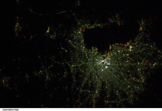
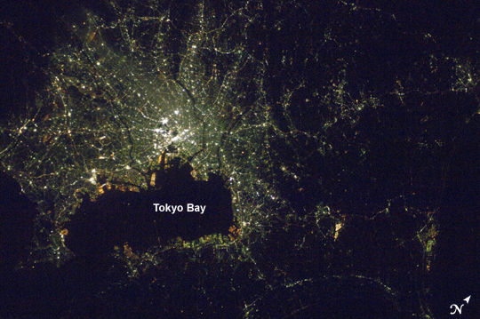
Mission: ISS016 Roll: E Frame: 27586 Mission ID on the Film or image: ISS016Country or Geographic Name: JAPAN
Features: TOKYO-YOKOHAMA AREA AT NIGHT
Center Point Latitude: 35.5 Center Point Longitude: 140.0 (Negative numbers indicate south for latitude and west for longitude)
Stereo: (Yes indicates there is an adjacent picture of the same area)
ONC Map ID: JNC Map ID:
Camera
Camera Tilt: 18Camera Focal Length: mm
Camera: N2: Nikon D2Xs
Film: 4288E : 4288 x 2848 pixel CMOS sensor, RGBG imager color filter.
Quality
Film Exposure:Percentage of Cloud Cover: 10 (0-10)
Nadir
Date: 20080205 (YYYYMMDD)GMT Time: 140827 (HHMMSS)Nadir Point Latitude: 35.2, Longitude: 139.1 (Negative numbers indicate south for latitude and west for longitude)
Nadir to Photo Center Direction: East
Sun Azimuth: 327 (Clockwise angle in degrees from north to the sun measured at the nadir point)
Spacecraft Altitude: 180 nautical miles (333 km)
Sun Elevation Angle: -68 (Angle in degrees between the horizon and the sun, measured at the nadir point)
Orbit Number: 760
Captions
Tokyo at NightIn the daytime, humanity's footprints on Earth are visible in numerous ways, even from space: the geometric patterns of our croplands, lush golf courses springing up from the desert like manmade oases, decades of river flow captured in reservoirs behind massive dams. When the Sun goes down, however, only one kind of footprint remains visible: our cities.
Images of city lights at night taken by astronauts are among the most interesting visual reminders of how humans have transformed Earth's surface. This nighttime photograph of Tokyo, Japan, was taken by International Space Station astronaut Dan Tani on February 5, 2008. The heart of the city is brightest, with ribbons of lights radiating outward from the center along streets and railways. The regularly spaced bright spots along one of the ribbons heading almost due west out of the downtown area are probably train stations along a public transit route. The lights of Tokyo are a cooler blue-green color than many other world cities. The color results from the more widespread use of mercury vapor lighting as opposed to sodium vapor lighting, which produces an orange-yellow light.
Download Packaged File.
This option downloads the following items, packaged into a single file, if they are available:
- Browse image
- Cataloged information with captions
- Camera file
- Sound file
Server: 2 |
This service is provided by the International Space Station program. |
Recommended Citation: |
||

