| Home >> | Advanced Search >> |
 |
|
Astronaut Photography of Earth - Display Record
ISS013-E-26488

Low-resolution Browse Image
(Most browse images are not color adjusted.)Images
Conditions for Use of Images >>Image Transformation Tutorial >> Saving, Color Adjusting, and Printing Images >>
Images to View on Your Computer Now
| File Name | File Size (bytes) | Width | Height | Annotated | Cropped | Purpose | Comments | |
|---|---|---|---|---|---|---|---|---|
| View | ISS013-E-26488.JPG | 114431 | 639 | 435 | No | No | ||
| View | ISS013-E-26488.JPG | 362878 | 540 | 379 | Yes | Yes | NASA's Earth Observatory web site |
Large Images to Request for Downloading
| File Name | File Size (bytes) | Width | Height | Annotated | Cropped | Purpose | Comments | |
|---|---|---|---|---|---|---|---|---|
| Request | ISS013-E-26488.JPG | 1015009 | 1000 | 701 | No | Yes | NASA's Earth Observatory web site | |
| Request | ISS013-E-26488.JPG | 1375567 | 3032 | 2064 | No | No |
Download a Keyhole Markup Language (KML) file for use in Google Earth.
Electronic Image Data
Camera Files >> No sound file available.Identification
Mission: ISS013 Roll: E Frame: 26488 Mission ID on the Film or image: ISS013Country or Geographic Name: USA-TEXAS
Features: OIL FIELDS, IRAAN, PECOS RIVER
Center Point Latitude: 30.9 Center Point Longitude: -101.9 (Negative numbers indicate south for latitude and west for longitude)
Stereo: (Yes indicates there is an adjacent picture of the same area)
ONC Map ID: JNC Map ID:
Camera
Camera Tilt: 12Camera Focal Length: 800mm
Camera: E4: Kodak DCS760C Electronic Still Camera
Film: 3060E : 3060 x 2036 pixel CCD, RGBG array.
Quality
Film Exposure:Percentage of Cloud Cover: 10 (0-10)
Nadir
Date: 20060525 (YYYYMMDD)GMT Time: 204741 (HHMMSS)Nadir Point Latitude: 31.3, Longitude: -101.4 (Negative numbers indicate south for latitude and west for longitude)
Nadir to Photo Center Direction: Southwest
Sun Azimuth: 258 (Clockwise angle in degrees from north to the sun measured at the nadir point)
Spacecraft Altitude: 184 nautical miles (341 km)
Sun Elevation Angle: 60 (Angle in degrees between the horizon and the sun, measured at the nadir point)
Orbit Number: 2964
Captions
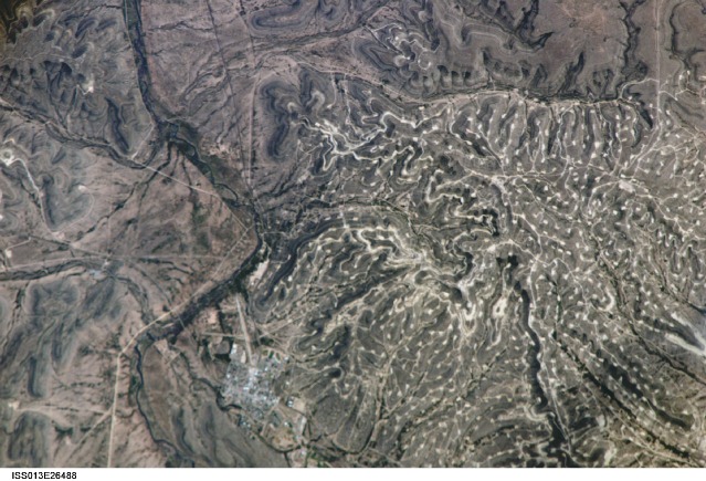
Yates Oilfield, West TexasThe Permian Basin of west Texas and southeastern New Mexico is one of the most productive petroleum provinces of North America. The area holds one of the thickest deposits of rock from the Permian Period, which lasted from approximately 290 to 251 million years ago. The Basin is a large depression in the bedrock surface along the southern edge of the North American craton, an ancient core of continental crust. The Basin filled with thick layers of sediment during the Paleozoic Era (about 545 to 251 million years ago) as the region was alternately covered by shallow oceans, or exposed as coastal salt flats. The sediments hardened into primarily organic-rich carbonate and minerals such as common table salt. Later activity in the Earth’s crust caused folding of the sedimentary layers, creating ideal conditions for the formation, trapping, and storage of petroleum.
In this astronaut photograph, numerous white well locations and petroleum drilling structures mark the Yates Oil Field in the layered sedimentary rocks of the Permian Basin. The Pecos River bed borders the oil field to the east-northeast. The nearby city of Iraan, Texas, is named for Ira and Ann Yates, the owners of the land where oil was initially discovered in 1926. The city grew in direct proportion to increasing development of the oil field. Today, the town stands out from the underlying sinuous landscape with its sharp angles and straight lines.
The Yates Field started petroleum production in 1926, and by 1995 had produced over 2 billion barrels of oil. While the Yates Field was still actively producing oil and natural gas in 2006, new petroleum discoveries in the area were considered unlikely due to the already-dense well development.
Download Packaged File.
This option downloads the following items, packaged into a single file, if they are available:
- Browse image
- Cataloged information with captions
- Camera file
- Sound file
Server: 2 |
This service is provided by the International Space Station program. |
Recommended Citation: |
||

