| Home >> | Advanced Search >> |
 |
|
Astronaut Photography of Earth - Display Record
ISS010-E-22495

Low-resolution Browse Image
(Most browse images are not color adjusted.)Images
Conditions for Use of Images >>Image Transformation Tutorial >> Saving, Color Adjusting, and Printing Images >>
Images to View on Your Computer Now
| File Name | File Size (bytes) | Width | Height | Annotated | Cropped | Purpose | Comments | |
|---|---|---|---|---|---|---|---|---|
| View | ISS010-E-22495.JPG | 86716 | 639 | 435 | No | No | ||
| View | ISS010-E-22495.JPG | 786644 | 540 | 690 | Yes | Yes | NASA's Earth Observatory web site |
Large Images to Request for Downloading
| File Name | File Size (bytes) | Width | Height | Annotated | Cropped | Purpose | Comments | |
|---|---|---|---|---|---|---|---|---|
| Request | ISS010-E-22495.JPG | 1282367 | 3032 | 2064 | No | No | ||
| Request | ISS010-E-22495.JPG | 2060379 | 1000 | 1277 | No | Yes | NASA's Earth Observatory web site |
Download a Keyhole Markup Language (KML) file for use in Google Earth.
Electronic Image Data
Camera Files >> No sound file available.Identification
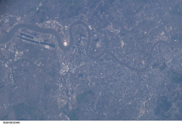
Mission: ISS010 Roll: E Frame: 22495 Mission ID on the Film or image: ISS010Country or Geographic Name: UK-ENGLAND
Features: R. THAMES, CITY OF LONDON,DOME
Center Point Latitude: 51.5 Center Point Longitude: -0.2 (Negative numbers indicate south for latitude and west for longitude)
Stereo: (Yes indicates there is an adjacent picture of the same area)
ONC Map ID: JNC Map ID:
Camera
Camera Tilt: High ObliqueCamera Focal Length: 800mm
Camera: E4: Kodak DCS760C Electronic Still Camera
Film: 3060E : 3060 x 2036 pixel CCD, RGBG array.
Quality
Film Exposure:Percentage of Cloud Cover: 10 (0-10)
Nadir
Date: 20050402 (YYYYMMDD)GMT Time: 123214 (HHMMSS)Nadir Point Latitude: 51.6, Longitude: 5.5 (Negative numbers indicate south for latitude and west for longitude)
Nadir to Photo Center Direction: West
Sun Azimuth: 197 (Clockwise angle in degrees from north to the sun measured at the nadir point)
Spacecraft Altitude: 191 nautical miles (354 km)
Sun Elevation Angle: 42 (Angle in degrees between the horizon and the sun, measured at the nadir point)
Orbit Number: 378
Captions
London, United KingdomNumerous well-known landmarks appear in this detailed view of London taken from the International Space Station. To capture the shot, the astronaut had to look back along the Space Station’s ground track, from a position over northern Germany. The most striking visual features are green open spaces such as Regent’s Park, Hyde Park and St. James’s Park east of Buckingham Palace. Many smaller parks indicate why Londoners are proud of being able to walk miles through the city mainly on grass. The River Thames—with its bridges and barges (some of the more than 14,000 craft registered to sail the Thames)—is the axis upon which the city was founded in Roman times.
The relatively small area known as the City of London coincides with the ancient walled Roman city of Londinium on the north bank of the river (the line of the wall is marked closely for almost its entire length by modern streets), and includes St. Paul’s Cathedral near where the Roman temple stood. For scale, the river is 265 meters wide near St. Paul’s. The City is the financial center while Westminster is the center of government, including the Houses of Parliament and 10 Downing Street, where the British Prime Minister lives.
Several large structures visible in this image are railroad stations: three serving areas north of London (Euston, St. Pancras, and King’s Cross), and Waterloo Station serving southern Britain. The London Eye, a famous Ferris wheel 140 meters high, is situated on an oval island in the River Thames, visible just west of Waterloo Station. Many larger buildings can also be identified, partly because they cast shadows— Buckingham Palace, St Paul’s Cathedral, and the Tate Modern art museum (a converted power station whose 99-meter chimney was designed to fall just short of the crest of St Paul’s dome).
Download Packaged File.
This option downloads the following items, packaged into a single file, if they are available:
- Browse image
- Cataloged information with captions
- Camera file
- Sound file
Server: 2 |
This service is provided by the International Space Station program. |
Recommended Citation: |
||

