| Home >> | Advanced Search >> |
 |
|
Astronaut Photography of Earth - Display Record
ISS012-E-21250

Low-resolution Browse Image
(Most browse images are not color adjusted.)Images
Conditions for Use of Images >>Image Transformation Tutorial >> Saving, Color Adjusting, and Printing Images >>
Images to View on Your Computer Now
| File Name | File Size (bytes) | Width | Height | Annotated | Cropped | Purpose | Comments | |
|---|---|---|---|---|---|---|---|---|
| View | ISS012-E-21250.JPG | 63653 | 639 | 435 | No | No | ||
| View | ISS012-E-21250.JPG | 436963 | 540 | 820 | Yes | Yes | NASA's Earth Observatory web site |
Large Images to Request for Downloading
| File Name | File Size (bytes) | Width | Height | Annotated | Cropped | Purpose | Comments | |
|---|---|---|---|---|---|---|---|---|
| Request | ISS012-E-21250.JPG | 1077224 | 3032 | 2064 | No | No | ||
| Request | ISS012-E-21250.JPG | 1250090 | 1000 | 1518 | No | Yes | NASA's Earth Observatory web site |
Download a Keyhole Markup Language (KML) file for use in Google Earth.
Electronic Image Data
Camera Files >> No sound file available.Identification
Mission: ISS012 Roll: E Frame: 21250 Mission ID on the Film or image: ISS012Country or Geographic Name: CHINA
Features: SMOG HAZE, DUST HAZE,BOHAI B.
Center Point Latitude: 41.0 Center Point Longitude: 119.0 (Negative numbers indicate south for latitude and west for longitude)
Stereo: (Yes indicates there is an adjacent picture of the same area)
ONC Map ID: JNC Map ID:
Camera
Camera Tilt: High ObliqueCamera Focal Length: 50mm
Camera: E4: Kodak DCS760C Electronic Still Camera
Film: 3060E : 3060 x 2036 pixel CCD, RGBG array.
Quality
Film Exposure:Percentage of Cloud Cover: 25 (11-25)
Nadir
Date: 20060321 (YYYYMMDD)GMT Time: 075704 (HHMMSS)Nadir Point Latitude: 38.3, Longitude: 123.2 (Negative numbers indicate south for latitude and west for longitude)
Nadir to Photo Center Direction: Northwest
Sun Azimuth: 251 (Clockwise angle in degrees from north to the sun measured at the nadir point)
Spacecraft Altitude: 185 nautical miles (343 km)
Sun Elevation Angle: 23 (Angle in degrees between the horizon and the sun, measured at the nadir point)
Orbit Number: 1931
Captions
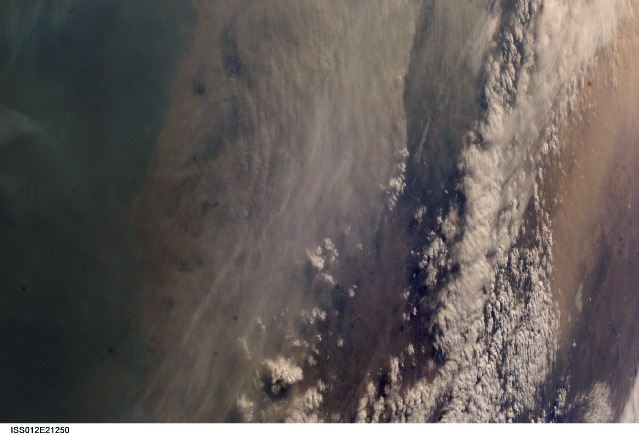
Dust and Smog in Northeast ChinaMuch of the land surface is obscured in this oblique image of the North China Plain and parts of Inner Mongolia. In this image, a mass of gray smog—mainly industrial pollution and smoke from domestic burning—obscures Beijing and surrounding cities. Numerous plumes with their source points appear within the mass. Beijing suffers some of the worst air pollution in the world from these chronic sources, and the characteristic colors and textures of the smog can be easily seen through the windows of the International Space Station. The pale brown material in Bo Hai Bay, about 300 kilometers east of Beijing, is sediment from the Yellow River and other rivers.
Separated from the smog mass by a band of puffy, white cumulus clouds is a light brown plume of dust. The line of white clouds has developed along the steep slope that separates the heavily populated North China Plain—the location of the largest population concentration on Earth—and the sparsely populated semi-desert plains of Inner Mongolia. Most Northern Hemisphere deserts saw dust storms in the spring of 2006, and the Gobi and Taklimakan Deserts of western China were no exception. Dust plumes originating in these deserts typically extend hundreds of kilometers eastward, regularly depositing dust on Beijing, the Korean Peninsula, and Japan. Some plumes even extend over the Pacific Ocean. In extreme cases, visible masses of Gobi-derived dust have reached North America.
An astronaut handheld-camera image taken in 1996 shows a broad corridor of smog moving off the mainland out into the Pacific Ocean from China’s more southerly population center near Taiwan.
Download Packaged File.
This option downloads the following items, packaged into a single file, if they are available:
- Browse image
- Cataloged information with captions
- Camera file
- Sound file
Server: 2 |
This service is provided by the International Space Station program. |
Recommended Citation: |
||

