| Home >> | Advanced Search >> |
 |
|
Astronaut Photography of Earth - Display Record
ISS005-E-21126

Low-resolution Browse Image
(Most browse images are not color adjusted.)Images
Conditions for Use of Images >>Image Transformation Tutorial >> Saving, Color Adjusting, and Printing Images >>
Images to View on Your Computer Now
| File Name | File Size (bytes) | Width | Height | Annotated | Cropped | Purpose | Comments | |
|---|---|---|---|---|---|---|---|---|
| View | ISS005-E-21126.JPG | 84882 | 639 | 435 | No | No | ||
| View | ISS005-E-21126.JPG | 100349 | 540 | 872 | Yes | Yes | NASA's Earth Observatory web site | |
| View | ISS005-E-21126.JPG | 173888 | 540 | 334 | Photographic Highlights | (540 px resized images) | ||
| View | ISS005-E-21126_2.JPG | 375482 | 871 | 539 | Photographic Highlights | (actual files used) | ||
| View | ISS005-E-21126.JPG | 548493 | 1000 | 1469 | No | No | NASA's Earth Observatory web site |
Large Images to Request for Downloading
| File Name | File Size (bytes) | Width | Height | Annotated | Cropped | Purpose | Comments | |
|---|---|---|---|---|---|---|---|---|
| Request | ISS005-E-21126.JPG | 1622170 | 3032 | 2064 | No | No |
Download a Keyhole Markup Language (KML) file for use in Google Earth.
Electronic Image Data
Camera Files >> No sound file available.Identification
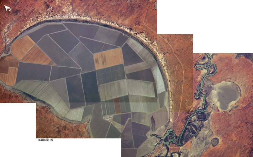
Mission: ISS005 Roll: E Frame: 21126 Mission ID on the Film or image: ISS005Country or Geographic Name: AUSTRALIA-NSW
Features: LAKE TANDOU, AGRICULTURE
Center Point Latitude: -32.5 Center Point Longitude: 142.0 (Negative numbers indicate south for latitude and west for longitude)
Stereo: (Yes indicates there is an adjacent picture of the same area)
ONC Map ID: JNC Map ID:
Camera
Camera Tilt: 25Camera Focal Length: 800mm
Camera: E4: Kodak DCS760C Electronic Still Camera
Film: 3060E : 3060 x 2036 pixel CCD, RGBG array.
Quality
Film Exposure:Percentage of Cloud Cover: 10 (0-10)
Nadir
Date: 20021121 (YYYYMMDD)GMT Time: 073503 (HHMMSS)Nadir Point Latitude: -32.3, Longitude: 140.3 (Negative numbers indicate south for latitude and west for longitude)
Nadir to Photo Center Direction: East
Sun Azimuth: 259 (Clockwise angle in degrees from north to the sun measured at the nadir point)
Spacecraft Altitude: 217 nautical miles (402 km)
Sun Elevation Angle: 21 (Angle in degrees between the horizon and the sun, measured at the nadir point)
Orbit Number: 2857
Captions
Sections of Australia are experiencing their worst drought in 100 years. In the outback of New South Wales, farms along the Darling River have received only 10 inches of rain in the past two years, forcing farmers to sell their livestock and let fields lie fallow. Astronauts aboard the International Space Station documented conditions in Australia last week, including these images of Lake Tandou in the Menindee Lake system along the Darling River.The Menindee Lakes are part of an innovative water conservation project. Although this lakebed is protected from flooding and is used for agriculture (primarily cotton, sunflower and grains), it is one of several interconnected lakes that sit along the lower Darling River like a string of pearls. Other lakes function as water capture reservoirs to support controlled water flow for environmental and agricultural needs down river, and to provide flood mitigation. The original water management scheme was initiated in 1949. Several recent policies have established sustainable management of the regional water supplies, including caps on water diversions and increased water allocations and flow regimes for environmental conservation — the region supports a very high biodiversity. The area is also near the center of the aboriginal Baakantji country, as they traveled up and down the Darling River.
Link to Earth Observatory Caption >>
Download Packaged File.
This option downloads the following items, packaged into a single file, if they are available:
- Browse image
- Cataloged information with captions
- Camera file
- Sound file
Server: 2 |
This service is provided by the International Space Station program. |
Recommended Citation: |
||

